![]()
Active Projects
In Construction
The purpose of this project is to improve the parking lots and related transit amenities at two Park and Ride Lots located in Manchester.
The Buckland Park and Ride Lot is located adjacent to Exit 62 along I-84 West. The proposed work includes installing two parallel bus platforms in the middle of the existing lot, which will include bus shelters, benches, trash cans, E-readers, bike racks, and electric vehicle charging stations. The entire lot will undergo appropriate pavement treatment and improved stormwater quality features.
The Spencer Park and Ride Lot is located adjacent to Exit 1 off Route I-384 West at the corner of Spencer Street and Cemetery Road. The proposed work includes removing the bus shelter from the lot and relocating it to Spencer Street eliminating the need for buses to enter the lot, installing a new bus shelter on Spencer Street, benches, trash cans, E-readers, bike racks, and electric vehicle charging stations. The entire lot will undergo appropriate pavement treatment and improved stormwater quality features.
Construction is expected to start spring of 2026 and will be complete by the end of 2026.
This project will replace the aging traffic signal infrastructure at eight (8) intersections along the Route 218 corridor in the Town of Bloomfield with new traffic signal equipment and replace the existing CTSS communications. The project limits on Route 218 are from Cigna Way/Bay Hill Drive to Granby Street. This project will provide full replacement of the traffic signal equipment and new fiberoptic interconnect at eight (8) intersections within the Route 218 corridor. The replacement of the CTSS communications system will establish reliable fiberoptic communication connections between the signalized intersections with wireless communications back to the Connecticut Department of Transportation’s Newington Administration building and will allow for the implementation of advanced technologies to monitor traffic and reduce travel times.
Construction is scheduled to begin Winter of 2025 and be completed by the end of 2026.
This project will replace the aging traffic signal infrastructure along the Route 99 (Silas Deane Highway) corridor with new traffic signal equipment and replace the existing communications system. This project includes a total of seventeen (17) traffic signal upgrades with four (4) of the locations being partial upgrades or minor modifications. The replacement of the CTSS communications system will establish reliable fiberoptic communication connections between the signalized intersections with wireless communications back to the Connecticut Department of Transportation’s Newington Administration building and will allow for the implementation of advanced technologies to monitor traffic and reduce travel times.
The project limits extend from Route 314 (Jordan Lane) in the Town of Wethersfield to Parsonage Street in the Town of Rocky Hill. In addition to the traffic signal reconstruction, the project includes extending the existing fiber optic communications system from Route 160 (Elm Street) in the Town of Rocky Hill to Parsonage Street.
Construction is expected to begin Winter of 2025 and be completed by end of 2026
This project will continue with the upgrading of bus shelters across the downtown Hartford. Approximately seventy-three (73) locations will be upgraded with new shelters and concrete pads.
Construction is expected to be completed by the end of 2026.
In Design
In coordination with the City of Hartford’s streetscape improvements along North Main Street, this project will also consolidate bus stops and upgrade approximately ten (10) shelters along North Main Street and Windsor Avenue.
The purpose of this project is to improve pedestrian connections across freeway ramps at eight (8) locations throughout the City of East Hartford. The existing sites are missing various pedestrian connectivity features such as crosswalks, sidewalks, curb ramps, pedestrian signal heads, and signage. This project proposes to increase the quality and number of pedestrian connections within the project limits, improve safety at pedestrian crossings, and enhance the comfort and security of pedestrians crossing highways and ramps. These ramps provide motorists access and egress from limited access highways including I-84, Route 2, and Route 5/15. The proposed improvements vary at each project site but can include crosswalks, pedestrian signals and actuators, pedestrian crossing signage and Rectangular Rapid Flashing Beacons (RRFBs), crosswalk illumination, ADA curb ramps, sidewalks, reduction of curb radii at ramp intersections, and elimination of right turn slip lanes.
This project proposes to provide improved pedestrian safety and connectivity at various roadways and expressway ramps at five (5) locations in Hartford. This project is part of an incremental approach to improve the quality and number of pedestrian connections to maximize pedestrian connectivity in the study area, improve safety at pedestrian crossings, and enhance the comfort and security of pedestrians crossing highways and ramps.
This project includes improving Pulaski Circle in the Bushnell South area of Hartford. This can be accomplished by changing the existing rotary to become a modern roundabout.
- The project will improve safety and make connections to Bushnell Park and the State Capitol. It will also slow down traffic and improve safety for bicyclists and pedestrians.
This project includes potential permanent ramp closures at the High Street I-84 eastbound on-ramp and Trumbull Street I-84 westbound off-ramp in Hartford.
- The ramp closures would lead to less need for lane changes within a short distance and would improve driver safety. This section of I-84 sees approximately 170,000 vehicles per day for both directions of travel, and drivers must quickly adjust to the merging traffic from multiple ramps within a short distance.
- This change is expected to improve safety by reducing the number of crashes in the area.
This project proposes to improve safety and traffic flow at the U.S. Route 44 (Albany Avenue) intersection with Main Street, High Street, and Ely Street in Hartford. The current conditions cause poor traffic operations and long pedestrian crossings.
- Safety improvements for passenger vehicles are proposed at the intersection of Albany Avenue and Pleasant Street, and pedestrian safety improvements are proposed at the intersection of Main Street and Belden Street.
The purpose of this project is to improve the Route 175/Route 9 ramp intersections in Newington and New Britain and provide improved sidewalk connections for pedestrians. The proposed improvements include addition of an exclusive right turn lane on the Route 9 northbound off-ramp, addition of a left turn lane on Route 175 eastbound at the Fenn Road intersection, extension of the Route 175 westbound left turn lane onto the Route 9 southbound on-ramp, and addition of a right turn lane on Route 175 eastbound at the Wells Street intersection. Proposed improvements also include realigning the Route 9 northbound off-ramp to better align with Fenn Road and to provide vertical curve improvements on the off-ramp.
The project also proposes to install sidewalk along Route 175 from Fenn Road to Old Farms Drive/Maple Avenue in anticipation of an increase in pedestrian movement to the CTfastrak Cedar Street Station & CCSU due to construction of apartments on “550 Cedar Street”. It is also proposed that sidewalks along Fenn Road be installed to connect existing segments of sidewalk and extend the sidewalk network up to the Ella Grasso Rd/Holly Drive intersection.
This project is located on Route 175 (East Street/Cedar Street) and Route 505 (Fenn Road) in the Town of Newington. The project area is approximately 3,500 feet long and extends east from the Route 175 intersection with Route 505 to where Route 175 intersects Maple Hill Avenue. The project includes the construction of a sidewalk along the north side of Route 175 to improve pedestrian accommodations and provide a continuous sidewalk network between pedestrian traffic generators and various transit, retail, and education facilities within and nearby the project area. The project also includes illumination, bus stop amenities, crosswalks, pedestrian traffic signal equipment, and pavement markings.
The project limits extend on Route 99 (Silas Deane Highway) from Town Line Road to Horizon Commons Driveway in the Town of Rocky Hill. This project proposes to realign the I-91 northbound and southbound ramps at the intersection with Route 99 (Silas Deane Highway). Slip ramps will be removed to create shorter pedestrian crossing at the ramps with fewer conflict points at lower speeds. Traffic signals at the ramps will be replaced and sidewalk will be installed under the I-91 overpass to connect to the existing sidewalk network on either side of the I-91 overpass bridge.
Ongoing Studies
This study is investigating the feasibility of constructing a multi-use trail along Route 218 (Cottage Grove Road) from Tyler Street in Bloomfield to Columbia Road in Windsor.
This study is investigating the feasibility of lowering and realigning I-84, Hartford Line Railroad, Union Station, and CTfastrak. The I-84/I-91 interchange would be relocated as well.
- The I-84/I-91 interchange would be relocated north of its existing location to facilitate ramp connections that meet design standards. The program would reconstruct I-84 as a lowered, at- or below-grade freeway between Park Street and the new interchange. It would continue across the Connecticut River before meeting its current alignment in East Hartford.
- The railroad would be reconstructed from approximately Sigourney Street through the Albany/Main Street tunnel. New platforms would be provided to access the rail service approximately 800 feet west of the existing Union Station.
- The existing I-91 and I-84 corridors would be reconstructed to facilitate the new interchange and to improve connections between the North End, Downtown, and the Connecticut River. The Bulkeley Bridge would be restored to its original local linkage between Hartford and East Hartford. Additional bus rapid transit (BRT) work would be included to provide a dedicated east-to-west BRT facility through the program limits.
This study is investigating the options for traffic calming and complete streets upgrades to Main Street in East Hartford. The project limits begin at Pitkin Street and end at Burnside Avenue. Five (5) intersections are being studied for upgrades that would improve vehicle and pedestrian safety and reduce vehicle speeds along Main Street. This may include relocating curb lines, installing medians, or other more substantial construction activities.
This study is investigating the feasibility of lowering and capping sections of I-91 and the construction of a new bridge for local traffic between East Hartford and Hartford. I-91 would be reconstructed to eliminate left-hand ramps and facilitate connections above the highway. The project may include connections across I-91 from the Founders Bridge to Dillon Stadium. It may also include a new Connecticut River crossing, extending the Whitehead Highway or Charter Oak Avenue to East River Drive. In either scenario, the Whitehead Highway would be reconstructed as an urban boulevard to eliminate limited-access ramps.
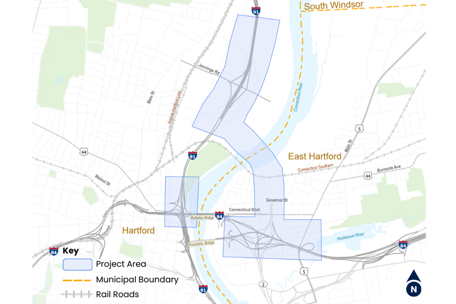
Through State Project No. 0042-0333 the Connecticut Department of Transportation (CTDOT) is proposing a direct connection between I-91 and Route 2 to alleviate congestion, improve safety and reduce traffic volume at the existing I-84/I-91 Interchange, and eliminate geometrically deficient ramps on the Bulkeley Bridge and I-84 in East Hartford. The proposed improvements would include an extension of Route 2 beyond the Governor Street ramp in East Hartford providing a direct connection to I-91, north of the existing I-84/I-91 interchange, with a new bridge over the Connecticut River north of the CT Southern Railroad Bridge. The project is currently undergoing federal and state environmental reviews and preliminary engineering. Route 2 Extension to I-91 Project Website