
Skys the Limit
Please note that this page is no longer active. All Sky's the Limit ("STL") Hiking and Walking Challenge information can be found on the Sky's the Limit Hiking webpage. The Sky's the Limit
Sky's the Limit Hiking Challenge 2021
The Sky's the Limit Hiking Challenge is designed to promote hiking and walking in Connecticut's State Parks and Forests. Please join CT DEEP State Parks as we ring in spring on March 20, 2021 with the release of the 2021 Sky's the Limit Hiking Challenge list of hikes and walks. The theme for this year is Bridges, Footbridges and Boardwalks. For this year's challenge, we have chosen 20 Park and Forest locations for you to visit.
Enjoy your time out in the CT State Parks and Forests for both long and short hikes and walks listening to the sounds of nature; while breathing the fresh air and taking in the sights leading to the various bridges, footbridges and boardwalks.
Participants in this friendly competition will once again have the opportunity to receive a hiking staff medallion for visiting at least fifteen designated locations. On January 1, 2022 names will be drawn from those who visited all twenty locations and 50 winners will receive a hand-carved hiking staff from the CT DEEP Sawmill. All entries are due by 3 pm on Friday, December 3, 2021.
If you post your photos on social media, please use the #CTSTL2021 or #CTStateParks.
Helpful Information: For the safety of fellow STL hikers, DEEP staff, and others enjoying the trails, please remember the following when walking and hiking with the STL Hiking Challenge:
-
If you’re not feeling well, stay home! Signs and symptoms of coronavirus include fever, cough and shortness of breath.
- If you arrive at a park or forest and crowds are forming, choose a different park and trail, or return another day or time.
-
Observe the CDC's minimum recommended social distancing of six feet from other people, whether you’re walking or hiking. Practice it and know what it looks like.
- Warn other trail users of your presence and as you pass to allow proper distance and step off trails to allow others to pass, keeping minimum recommended distances at all times. Signal your presence with your voice, bell, or horn.
-
While enjoying your hike or walk, be safe outdoors by staying on the marked trails, practicing social distancing, wearing a mask if you can't social distance, and most importantly, have fun exploring.
-
Follow the CDC's guidelines on personal hygiene prior to heading out on the trails. Wash your hands, carry hand sanitizer, cover your mouth and nose when coughing or sneezing, and avoid surfaces that are touched often, such as doorknobs, handrails and equipment.
-
Bring water or drinks.
-
Bring a whistle, sunblock, map and insect repellant.
-
Dress for the weather. It is best to dress in layers. As you warm up while hiking, you can remove outer layers.
-
Hunting is allowed in most state forests and some state parks so check out the CT Hunting and Trapping Guide and don't forget to wear orange during hunting season. Also, bring a whistle or make noise so hunters know you are in the area.
-
Be Bear Aware and do make your presence known by making noise while hiking. If you see a bear, make enough noise and wave your arms so the bar is aware of your presence.
-
Remember to protect yourself from Lyme disease and other tick-borne diseases.
-
Dogs must be on a leash for their safety, the safety of wildlife and fellow hikers. Please see Notes section below for more information.
-
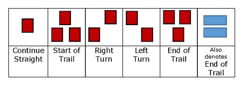
Don't forget to bring a map and know what the trail blazes mean (don't think just because there is a wide open trail that is the correct way to go, there might be a spur trail that is not obvious.
-
Be aware of your surroundings and check out options. There might be a trail that takes you around a steep area, consult your map.
-
Remember to check the State Parks Twitter to confirm the park is open and plan your trip accordingly. With the Passport to Parks Program, Connecticut residents are no longer required to pay a parking fee at CT State Parks and Forest recreation areas, due to DMV collecting a $10 fee ($5 per year) on behalf of DEEP at the time of registration and registration renewals for non-commercial motor vehicles.
The Sky’s the Limit Hiking Challenge promotes hiking and walking in Connecticut’s State Parks and Forests.
Challenge family, friends, co-workers and neighbors to take the Sky’s the Limit Hiking Challenge 2021.
Please follow the steps below.
Step 1: Hike or walk the listed trails within the 20 CT State Parks or Forests.
Step 2: Snap a photo of yourself (and your dog if he/she joins you) by a designated sign in the park or forest (this could be a state park shield sign, a sign in a kiosk with the name of the state park or forest, or a trail sign identifying the location).
Step 3: Take a second photo of yourself (and your dog if he/she joins you) at the location(s) described in the specific write-up below. Please note: Many locations will require several photos be taken.
Step 4: To receive a medallion and certificate, email your photos from each of the fifteen parks and forests listed below, along with your name (and your dog's name, if applicable), address, email, phone number and signed photo release, to DEEP.SkystheLimit@ct.gov or mail to CT DEEP State Parks, Sky’s the Limit, 79 Elm St., Hartford, CT 06106. Entries must be received by 3 pm on Friday, December 3, 2021.
Step 5: To be entered to win a hiking staff, send your photos (as described herein) from all twenty locations, along with your name (and your dog's name, if applicable), address, email, phone number and signed photo release to the email or mailing address above. On January 1, 2022, 50 winners will be chosen to receive a hand carved hiking staff. Entries must be received by 3 pm on Friday, December 3, 2021 to be entered into the drawing.
Notes: For the 2021 Sky's The Limit, we are asking the STL hikers to provide one submission, such as a word document to DEEP.SkystheLimit@ct.gov that includes a listing of all of the locations that were hiked with the associated photographs. Please provide attachments, (photo or document) not links to external sources (Google drive, Facebook, etc.). We often have a difficult time accessing external sources. Please be sure to also include the following information: name, address, email, phone number, and signed photo release Photo Release Form (each STL hiking participant shall submit a signed Photo Release). This form can be printed out, filled out and then a photo of the form can be taken and sent in with your submission.
The majority of the park and forest maps attached below take you to DEEP maps (some of which are Georeferenced PDF Maps). There are other non-DEEP map references as well, for example, AllTrails maps and Google maps.
Please check out the additional information section below for suggestions of other hikes on-site and other things to do while at the various State Park or Forest locations below.
Since many of our STL participants hike with their canine friends, we will have a special give-away for the dogs this year.
Please read the following if hiking with a canine friend: The majority of Connecticut State Parks allow dogs, but according to state regulations the dogs must be on a leash no longer than 7-feet and under the control of the owner or keeper at all times. The shoreline parks (Harkness, Rocky Neck, Silver Sands, and Sherwood Island) prohibit dogs on the beach year-round. Leashed dogs are allowed on the beach at Hammonasset Beach State Park ONLY from September 30 through April 1, but they are not allowed at Sherwood Island State Park, anywhere in the park, from April 15-September 30. The “no dogs on the beach” rule provides protection for beach-nesting shorebirds, like piping plovers and least terns. Before bringing your dog to one of the state parks or forests, check “Related Information” on each individual park or forest webpage on the DEEP website to read the rules for pets and also visit the Responsible Recreation section of the DEEP website.
2021 Sky’s the Limit Hiking Challenge Locations:
1. State Park or Forest: Dinosaur State Park, Rocky Hill
Trail Name: Red trail connecting to the boardwalk, then to the Blue Trail
Parking Area: Main parking area
Photo Locations (5): Trail information building, boardwalk at start, pick one of the Interpretive signs (educational signs) on the trail, decorated bat box, boardwalk on blue trail
Degree of Difficulty: Easy to Moderate
Approximate Length: Approximately .75 miles
Additional Information: Please note that dogs are allowed at Dinosaur State Park, however, are not allowed on the trails. Check out the Native Plants and Butterfly Garden. If open, visit the Dinosaur State Park Exhibitors Center and Casting Area (note: fee charged to get into the center and for casting)
2. State Park or Forest: Lovers Leap State Park, New Milford
Trail Name: Lovers Leap Trail, Blue Trail (labeled on map as brown trail)-Waramaug Loop
Map: Lovers Leap State Park Map (see link above for Lovers Leap Trail)
Parking Area: Parking area by entrance
Photo Locations (4): Iron Bridge, Highlights of Lovers Leap State Park Interpretive sign, Indian Spring House, photo of your choosing
Degree of Difficulty: Easy to Moderate
Approximate Length: Varies
Additional Information: Visit the Hurd Estate Trails to find some interesting structural remnants
3. State Park or Forest: Silver Sands State Park, Milford
Trail Name: Timber boardwalk leading to the beach and the boardwalk that parallels the beach and crosses the creek
Map: Silver Sands State Park Map, Silver Sands State Park Boardwalk Map (Note: non-DEEP map, AllTrails Map)
Parking Area: Various locations
Photo Locations (2): New Concession building, Bench with viewing scope on the boardwalk
Degree of Difficulty: Easy
Approximate Length: Approximately 2 miles
Additional Information: Continue your walk by looping back into the park or spending some time on the beach exploring
4. State Park or Forest: Hammonasset Beach State Park, Madison
Trail Name: Cedar Island Trail
Map: Hammonasset Beach State Park Map
Parking Area: Parking lot next to the Meigs Point Nature Center or parking lot near trail (behind nature center, near the trail head)
Photo Locations (3): The Hammonassetts Plaque on the large rock/boulder before heading onto the trail, photo looking out from the viewing platform towards Long Island Sound, interpretive signage (educational signage) on the viewing platform
Degree of Difficulty: Easy
Approximate Length: Approximately .6 miles
Additional information: Head out to Williards Island after the Cedar Island Trail or if open, visit Meigs Point Nature Center or visit the Meigs Point Nature Center Virtual Learning Center
5. State Park or Forest: Black Rock State Park, Watertown
Trail Name: Follow the Unblazed Trail to the footbridge, connecting to the Blue Trail to the Red Trail and looping back to the Blue Trail
Map: Black Rock State Park Map
Parking Area: Parking areas between the ticket booth and the Park Office
Photo Locations (3): Footbridge, Bridge, photo from the area labeled on the map as scenic vista
Degree of Difficulty: Easy to Moderate
Approximate Length: Approximately 1.4 miles
Additional Information: Head up to Black Rock Pond and enjoy a picnic lunch
6. Park or Forest: Chatfield Hollow State Park, Killingworth
Trail Name: Follow the paved park road to the Paul Wildermann Boardwalk; to the paved park road to the Purple Trail ; to the park paved road
Map: Chatfield Hollow State Park Map
Parking Area: parking area by the ticket booth or the parking area near the Paul Wildermann Boardwalk
Photo Locations (3): The Paul F. Wildermann Boardwalk (please note the boardwalk is not open to the public at this time), Red Covered Bridge, any other bridge, footbridge or boardwalk along the hiking/walking area
Degree of Difficulty: Paved park road-Easy; Purple Trail - easy to moderate
Approximate Length: Varies on parking location (1 miles to 3 miles)
Additional Information: Visit the Orange Trail (DEEP Woods Trail), Blue Trail East Woods & West Crest Trails or the Yellow Trail (Nature Trail)
7. Park or Forest: Collis P. Huntington State Park, Bethel, Newtown & Redding
Trail Name: Blue Trail to White Trail (by West Lagoon) to Red Trail (by Lake Hopewell) to White Trail (by geologic feature and South Pond) to Blue Trail
Map: Collis P. Huntington State Park Map
Parking Area: Parking area off of Old Dodgington Road
Photo Locations (2): Trail bridge of your choosing and the Collis P. Huntington State Park signage with hand drawn trails and hand drawn explanation (key)
Degree of Difficulty: Easy to Moderate
Approximate Length: Approximately 2.5 miles
Additional Information: Visit the bear and wolf statues by the Park Entrance, geologic features and ruins
8. Park or Forest: Southford Falls State Park, Oxford
Trail Name: Red Trail loop
Map: Southford Falls State Park Map
Parking Area: Parking lot by Park Entrance
Photo Locations (3): Covered Red Bridge, bridge near parking lot, boardwalk on the Red Trail
Degree of Difficulty: Moderate (rocky)
Approximate Length: Approximately 1.7 miles
Additional Information: View the lily pads on the lake and waterfall from a distance, as well as the Fire Tower for a view of the area.
9. Park or Forest: Wharton Brook State Park, Wallingford
Trail Name: Unpaved park road leading to the Foot Trail (within Wharton Brook Natural Area Preserve)
Map: Wharton Brook State Park Map
Parking Area: Parking area closest to Allen Brook Pond
Photo Locations (2): Bridge over Wharton Brook and the Pitch Pine Natural Area Preserve sign
Degree of Difficulty: Easy
Approximate length: Approximately 1 mile
Additional Information: Visit the other areas of the park and eat or snack or have a picnic and time permitting, bring your fishing license and fishing rod and try to catch a trout
10. Park or Forest: Wadsworth Falls State Park, Middletown
Trail Name: Main Trail entrance leading to Purple Trail
Map: Wadsworth Falls State Park Map
Parking Area: Parking area by Park entrance off of Conn 157
Photo Locations (2): Covered Bridge and the stone arch bridge
Degree of Difficulty: Easy
Approximate Length: Approximately 1 mile
Additional Information: Visit the Orange Main Trail to view the Cogincahug River and the falls
11. Park or Forest: Peoples State Forest, Barkhamsted
Trail Name: Blue Trail to Blue/Red Trail (loop hike from Pavillion to boardwalk)
Map: American Legion and Peoples State Forest Map
Parking Area: Parking area off of East River Road between picnic pavilion and Matthies Grove
Photo Locations (3): Agnes Bowen Trail/Robert Ross Trail signs, pick one of the interpretive signs (educational signs) leading to or on the boardwalk/viewing platform, view out into the wetland along the boardwalk
Degree of Difficulty: Moderate
Approximate length: Approximately 3.5 miles round trip
Additional Information: Visit one of several other trails at the location, the pavilion or if open, the Nature Center
12. Park or Forest: Ferry Landing State Park (DEEP Marine Headquarters), Old Lyme
Trail Name: Follow the paved area to a timber walkway which runs along the upland; leading to a timber boardwalk over the water
Map: Ferry Landing State Park Map (Google Map), DEEP Boardwalk Ferry Landing State Park (AllTrails Map)
Parking Area: Parking area on Ferry Road (on the left) before reaching DEEP Marine Headquarters
Photo Locations (5): Photo of How Well Do you Know Boating kiosk, photo of railroad bridge, photo of Blue Crab Regulations sign, photo of osprey platform interpretive signage (educational signage) with island/osprey platform in background; and photo of the CT River from anywhere along the timber walkway or timber boardwalk
Degree of Difficulty: Easy
Approximate Length: Approximately .54 miles
Additional Information: Spend time reading the numerous interpretive signs posted along the timber boardwalk over the water and enjoy the views of the CT River from the gazebo
13. Park or Forest: Kent Falls State Park, Kent
Trail Name: Red Trail to Yellow Trail Loop
Map: Kent Falls State Park Map
Parking Area: Main parking lot past Park Entrance
Photo Locations (3): Covered Red Bridge, timber footbridge, Bridge on Dugan Road (at the end of the Red Trail),
Degree of Difficulty: Difficult due to being steep
Approximate Length: Approximately 1.5 miles
Additional Information: Climb the stairs to view the falls safely
14. Park or Forest: Cockaponset State Forest, Chester & Haddam
Trail Name: Cockaponset Trail (Blue Trail) section from Main Street (Rte 148) up to Jericho Road
Parking Area: Parking area by Main Street, parking area by Pattaconk Reservoir or parking area by Jericho Road
Photo Locations (4): 2 bridge locations/crossings along the Blue Trail, area labeled on the map as Collier's Hut Remains, and area labeled on the map as Observation Tower Remnants
Degree of Difficulty: Moderate to Difficult
Approximate Length: Approximately 6.5 miles
Additional Information: Visit Pattaconk Reservoir and boat launch, or visit an adirondak shelter off of the Blue/Yellow Trail
15. Park or Forest: Sherwood Island State Park, Westport
Trail Name: Beach walkway and Nature Trail
Map: Sherwood Island State Park Map
Parking Area: East Beach parking lot or overflow parking area
Photo Locations (3): Living 9/11 memorial (just a photo of the memorial, no selfie), 2 locations (stops) along the Nature Trail
Degree of Difficulty: Easy to Moderate
Approximate Length: Approximately 1.5 miles
Additional Information: Visit the area on the map labeled model aircraft planes or if open, visit the Nature Center
16. Park or Forest: Devil's Hopyard State Park, East Haddam
Trail Name: Orange (O)-Vista Trail
Map: Devil's Hopyard State Park Map
Parking Area: Parking area off of Hopyard Road
Photo Locations (2): Covered bridge along the Eight Mile River, and a photo taken from the area marked on the map as Scenic View
Degree of Difficulty: Moderate
Approximate Length: Approximately 1.6 miles
Additional Information: Visit Chapman Falls (waterfall) and Devil's Den
17. Park or Forest: Stratton Brook State Park, Simsbury
Trail Name: Red Trail to the Orange Trail
Map: Stratton Brook State Park Map
Parking Area: Parking area near the roundabout
Photo Locations (2): Covered Bridge and the Pavillion
Degree of Difficulty: Easy
Approximate Length: Approximately .5 miles
Additional Information: Visit the Farmington River Trail or the White Trail through the Ensign Memorial Forest
18. Park or Forest: Salmon River State Forest, Colchester
Trail Name: Salmon River Trail-Blue
Map: Salmon River State Forest and Day Pond State Park Map
Parking Area: Parking area near covered bridge or parking area near the park entrance
Photo Locations (2): Covered bridge, area labeled on map as Salmon River Trail Scenic Vista
Degree of Difficulty: Moderate to difficult due to length
Approximate Length: Approximately 4.5 miles
Additional Information: Visit the Day Pond Brook Spur Trail or Day Pond
19. Park or Forest: Osbornedale State Park, Derby
Trail Name: Red Trail and area labeled on map as No Blaze
Map: Osbornedale State Park Map
Parking Area: Parking area near Kellogg Environmental Center/Osborne Homestead Museum and/or various parking areas within park
Photo Locations (3): Boardwalk/footbridge across from Osborne Homestead Museum, a geologic feature found along the Red Trail, and boardwalk located along the trail
Degree of Difficulty: Moderate
Approximate Length: Approximately 2.5 miles
Additional Information: Spend time sitting on a bench or on the wall of Pickett's Pond or visit the Kellogg Environmental Center or the Osborne Homestead Museum, if open. During the spring and summer, visit the Kellogg Estate Gardens (adjacent to the Osborne Homestead Museum)
20. Park or Forest: Rocky Neck State Park, East Lyme
Trail Name: Boardwalk and White Trail
Map: Rocky Neck State Park Map
Parking Area: Parking locations vary throughout the park
Photo Locations (4): Anywhere on the beach boardwalk, Bride Brook, intersection of the White/Purple Trail, intersection White/Red Trail
Degree of Difficulty: Easy
Approximate Length: Approximately 2 miles
Additional Information: Visit the Rocky Neck Pavillion, Bakers Cave or Tony's Nose Overlook
Content last updated February 20, 2025