
June 6, 2017

June 6, 2017
- State Conservation and Development Policies: The Plan for Connecticut, 2018-2023 (State C & D Plan) - Revised Draft Available
- Spruce Ridge, Stonington
- State Pier Complex Improvements, New London
- Briar Cliff Booster Station and Long Meadow Water Main Extension, Bethel
- NEW! Derby Downtown Redevelopment Project, Derby
- NEW! Tylerville Water Main Extension, Haddam
- NEW! Bunker Hill Water Main and Sewer Extension, Watertown
- Montgomery Mills Redevelopment Project, Windsor Locks
- Commuter Railroad Station, Orange
- Exchange of Easements, Snyder Rd., Haddam
1. Conservation and Development Policies: The Plan for Connecticut, 2018-2023 (State C & D Plan)
The Office of Policy and Management (OPM) has published a revised draft of the Conservation and Development Policies: The Plan for Connecticut, 2018-2023 (Draft State C&D Plan), in accordance with CGS Section 16a-28(b). The Draft State C&D Plan, including the Draft Locational Guide Map, can be viewed at: https://www.ct.gov/opm/cwp/view.asp?a=2990&Q=587532&PM=1.
OPM, in cooperation with Regional Councils of Governments (COGs), will schedule, publicize, and conduct formal public hearings on the Draft State C&D Plan in each of the state’s nine planning regions over a five-month period.
Written comments from the public are welcomed and will be accepted until the close of business on October 16, 2017.
Written comments should be sent to:
Name: Daniel Morley
Agency: Office of Policy and Management
Address: 450 Capitol Avenue, MS #54 ORG
Hartford, CT 06106-1379
Fax: 860-418-6486
E-Mail: Daniel.Morley@ct.gov
"Scoping" is for projects in the earliest stages of planning. At the scoping stage, detailed information on a project's design, alternatives, and environmental impacts does not yet exist. Sponsoring agencies are asking for comments from other agencies and from the public as to the scope of alternatives and environmental impacts that should be considered for further study. Send your comments to the contact person listed for the project by the date indicated.
1. Notice of Scoping for Spruce Ridge
Municipality where proposed project might be located: Pawcatuck, CT within the Town of Stonington.
Addresses of Possible Project Location: 86-88 South Broad Street, Pawcatuck, CT 06379
Project Description: The Department of Housing (DOH) is considering using HOME funds to assist in the development of the 43-unit Spruce Ridge project in Pawcatuck, located within the Town of Stonington. The project is being completed by a Community Housing Development Organization (CHDO) eligible developer that would provide DOH with an avenue for meeting both our CHDO and general HOME commitment and expenditure requirements. Spruce Ridge is the second phase of this development at this location (86-88 South Broad Street). Each phase is located on a separate legal parcel. The first phase (known as Spruce Meadows, also comprising 43 units ) located at 100-102 South Broad Street was completed with 4% LIHTC and DOH state bond funding. Until this point in time, DOH did not contemplate using HOME funds for this project, but the lack of other CHDO eligible developments has made us reconsider the use of HOME funds. The first and second phases of this project are not related legally but they are being completed by the same parent organization and are located on adjacent parcels.
Project Map: Click here to view a map of the project area
Written comments from the public are welcomed and will be accepted until the close of business on: June 16, 2017
Any person can ask the sponsoring agency to hold a Public Scoping Meeting by sending such a request to the address below. If a meeting is requested by 25 or more individuals, or by an association that represents 25 or more members, the sponsoring agency shall schedule a Public Scoping Meeting. Such requests must be made by May 26, 2017.
Written comments and/or requests for a Public Scoping Meeting should be sent to:
Name: Jennifer Ponte
Agency: Department of Housing
Address: 505 Hudson Street, Hartford, CT 06106
Fax: (860) 706-5741
E-Mail: Jennifer.Ponte@ct.gov:
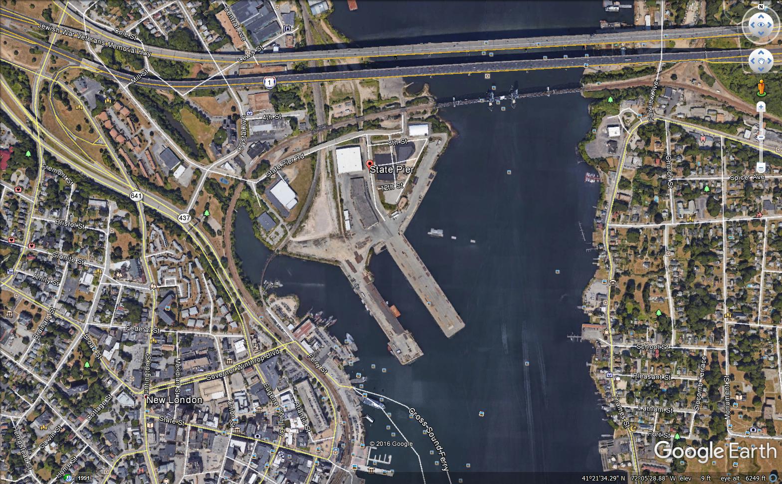
2. Notice of Scoping for State Pier Complex Improvements
Municipality where proposed project might be located: New London
Address of Possible Project Location: 200 State Pier Road, New London, CT. 06320
Project Description: The Department of Economic & Community Development upon the request of the Connecticut Port Authority has prepared this scoping notice. The Connecticut Port Authority is currently conducting a planning/design study related to the improvements needed at the State Pier Complex. The State Pier facility contains approximately 4,000 linear feet of dockage along its two main piers, on-dock rail connectivity to the New England Central Railroad (now owned by Genesee & Wyoming) system, 200,000 square feet of warehouse space, deep water access, and direct connection to the interstate highway system. The site is generally known as the State Pier Complex, which not only includes waterfront features such as piers and quay walls but also includes upland areas straddling State Pier Road and land north of the Gold Star Bridge.
In 2011, the State Pier Needs and Deficiency Planning Study was commissioned by the Connecticut Department of Transportation (CTDOT) to identify site-related and infrastructure repairs and improvements that would better position the facility to capture emerging East Coast shipping opportunities and accommodate some of the logistics generated by the $5 billion in cargo flow annually in Connecticut.
The existing physical plant was found generally to be in good condition relative to similar New England ports with some exceptions. Some of State Pier's greatest constraints are the limited near dock surface area available for cargo moves and laydown area and poor surface conditions. Dredging to achieve uniform depths for both piers and the poor structural and overall condition of the Central Vermont Railroad (CVRR) Pier are among the most challenging deficiencies that need to be remedied.
CTDOT has elected to proceed with preliminary design of improvements generally as outlined in the State Pier Needs and Deficiencies Study. The current design phase includes due diligence, development and evaluation of alternatives, and preliminary engineering followed by preliminary design. Due diligence includes:
- Site visits
- Subsurface soils investigations, both upland and in-water
- Structure inspections, including underwater
- Topographic survey (by CTDOT)
- Hydrographic survey
- Utility mapping
- Review of available environmental data for dredge materials
- Identification and mapping of regulatory limits
Assessment of alternatives involved structure rehabilitation options along with various upland grading schemes and site layout scenarios. Preliminary Design plans generally depict:
-
Site layout and circulation
-
Location of buildings, drives, parking, etc.
-
Access road design
-
Site security provisions
-
Site grading, retaining walls, and drainage
-
Structure rehabilitation plans and details
-
Dredge plans
-
Schematic utility and illumination layout
-
Track restoration layout and details
The Preliminary Design submission represents deliverables essentially considered 35% complete, which shall be submitted and reviewed by CTDOT. The goal of the 35% design is to further develop the project in an effort to better understand opportunities, impacts, and costs. This report is intended to address environmental, utility, right-of-way, and other constraints and needs. The Preliminary Design submission also includes an engineer's opinion of probable construction costs and will serve to further discussions with CTDOT relative to phasing the work.
Project Map(s): Click here to view a map of the project area. Click here to view an aerial photo of the State Pier.
Written comments from the public are welcomed and will be accepted until the close of business on: June 16, 2017
Any person can ask the sponsoring agency to hold a Public Scoping Meeting by sending such a request to the address below. If a meeting is requested by 25 or more individuals, or by an association that represents 25 or more members, the sponsoring agency shall schedule a Public Scoping Meeting. Such requests must be made by May 26, 2017.
Additional information about the project can be viewed online at the Connecticut Port Authority Website: www.portsct.com
Written comments and/or requests for a Public Scoping Meeting should be sent to
| Mr. Joseph Salvatore | |
|
Connecticut Port Authority |
|
|
505 Hudson Street - 3rd Floor |
|
| E-Mail: | joseph.salvatore@ct.gov |
3. Notice of Scoping for Briar Cliff Booster Station and Long Meadow Water Main Extension
Municipality where proposed project might be located: Bethel
Address of Possible Project Location: Nashville Road, Briar Cliff Manor and Long Meadow Lane
Project Description: The Bethel Water Department is currently under a consent order with the Connecticut Department of Public Health (DPH) to provide adequate pressure to the Briar Cliff Manor neighborhood. The Town of Bethel has applied for funding through the Drinking Water State Revolving Fund to install a booster pump station at the intersection of Nashville Road and Briar Cliff Manor to address low system pressures at the customer services on Briar Cliff Manor, Crestview Drive, and Long Meadow Lane. The underground booster pump station is designed to increase pressures above the 25 psi minimum pressure, as required by the Regulations of Connecticut State Agencies. In addition, construction of the proposed project would ensure adequate firefighting flows for the neighborhood. The project also includes the installation of approximately 600 feet of new 8" distribution water main from Briar Cliff Manor to Long Meadow Lane. The installation of the water main in Long Meadow Lane will allow the properties currently connected directly to the transmission main to reconnect to the properly pressurized water main via new service lines.
Project Map: Click here to view a map of the project area.
Written comments from the public are welcomed and will be accepted until the close of business on: June 17, 2017.
Any person can ask the sponsoring agency to hold a Public Scoping Meeting by sending such a request to the address below. If a meeting is requested by 25 or more individuals, or by an association that represents 25 or more members, the sponsoring agency shall schedule a Public Scoping Meeting. Such requests must be made by May 26, 2017.
Written comments and/or requests for a Public Scoping Meeting should be sent to
| Name: | Mr. Eric McPhee |
|
Department of Public Health
Drinking Water Section
|
|
|
410 Capitol Avenue, MS #12DWS
PO Box 340308
Hartford, CT 06134-0308
|
|
| Fax: | 860-509-7359 |
| E-Mail: | Dph.sourceprotection@ct.gov |
If you have questions about the public meeting, or other questions about the scoping for this project, contact:
| Name: | Ms. Patricia Bisacky |
|
Department of Public Health
Drinking Water Section
|
|
|
410 Capitol Avenue, MS #12DWS
PO Box 340308
Hartford, CT 06134-0308
|
|
| Phone: | 860-509-7333 |
| Fax: | 860-509-7359 |
| E-Mail: | Patricia.bisacky@ct.gov |
4. Notice of Scoping for Derby Downtown Redevelopment Project
Municipality where proposed project might be located: City of Derby
Project Location: South of Main Street/Route 34 (between the intersections with Route 8 westward to the Derby-Shelton Bridge)
Project Description: Urban Act Grant funds (through the Dept. of Economic and Community Development -DECD) will be used for utility infrastructure, road and sidewalk construction and streetscaping associated with downtown redevelopment in the City of Derby. The construction efforts will be focused in the area south of Main Street/Route 34 (between the intersections with Route 8 westward to the Derby-Shelton Bridge). The utility improvements are part of implementation of the Downtown Now!, Derby's Blueprint for Progress, a state-funded planning effort undertaken by the City. For more info on the proposed development plan, please visit the link to the presentation prepared for the November 17 Public Meeting/Charette. The planning effort has sparked private investment interest in the Downtown area consistent with the "U"Street Master Plan," endorsed by the City of Derby's Planning and Zoning Commission. The uses proposed as part of the U Street Master Plan include residential, commercial, office, light industrial (advanced manufacturing), training, and mixed uses. The public infrastructure investment will leverage and support this potential private investment. It may be noted that the federally-funded (through the Connecticut Department of Transportation) project, Reconstruction of Route 34/Main St. (Project #36-184), currently in the design stages, is along the northern boundary of the Project Area.
Project Maps: Click here to view a map of the project area and the "U" Street Master Plan concept.
Written comments from the public are welcomed and will be accepted until the close of business on: Thursday, July 6, 2017
Any person can ask the sponsoring agency to hold a Public Scoping Meeting by sending such a request to the address below. If a meeting is requested by 25 or more individuals, or by an association that represents 25 or more members, the sponsoring agency shall schedule a Public Scoping Meeting. Such requests must be made by Friday, June 16, 2017.
Written comments and/or requests for a Public Scoping Meeting should be sent to:
| Name: | Binu Chandy |
| Agency: | CT Dept. of Economic and Community Development |
| Address: | 505 Hudson Street, Hartford CT 06106 |
| Fax: | 860.706.5740 |
| E-Mail: | binu.chandy@ct.gov |
If you have questions about the public meeting, or other questions about the scoping for this project, contact:
| Name: | Binu Chandy |
| Agency: | CT Dept. of Economic and Community Development |
| Address: | 505 Hudson Street, Hartford CT 06106 |
| Phone: | 860.270.8154 |
| Fax: | 860.706.5740 |
| E-Mail: | binu.chandy@ct.gov |
5. Notice of Scoping for the Tylerville (Haddam) Water Main Extension
Municipalities where proposed project might be located: Haddam and Chester
Addresses of Possible Project Locations: Route 154/ Middlesex Turnpike in Chester and Route 154/ Saybrook Road in Haddam; Bridge Road, Little Meadow Road, Camp Bethel Road, Bethel Lane, South Side Bluff, Bridge Lane, and Brookes Court in Haddam.
Project Description: The Town of Haddam is seeking to extend the Connecticut Water Company's public water main from its current terminus on Route 154 at Denlar Drive in Chester. The water main would extend north along Route 154 approximately 2 miles to Tylerville Village in Haddam where groundwater contamination has polluted 18 residential drinking water wells above the Department of Public Health's Drinking Water Action Levels. The Department of Energy and Environmental Protection has studied the groundwater pollution in Tylerville and identified contaminated and at-risk properties. DEEP has determined that the 8-inch minimum pipe size is the preferred alternative to provide a reliable, long-term source of potable water to the area based on the extent and persistence of the pollutants and the resistance of one pollutant to carbon treatment. Fire hydrants will be installed along the water main as determined by the Towns and Connecticut Water Company.
Project Maps: View the Proposed Water Main Topographical Overview Map
View the Proposed Water Main Parcels Map
DATE: Wednesday, June 21, 2017
TIME: 7pm
PLACE: Haddam Fire House, 439 Saybrook Road, Haddam
NOTES: Prior to the meeting, an informal public information session will be held beginning at 6pm.
- Haddam Town Hall, Town Clerk's Office, 30 Field Park Drive, Haddam
- Chester Town Hall, 203 Middlesex Avenue, Chester
- Department of Energy and Environmental Protection, 79 Elm Street, Hartford (by appointment only, see contact information below)
Written comments should be sent to:
| Name: | Ms. Shannon Pociu |
| Agency: | Department of Energy and Environmental Protection |
| Remediation Division | |
| Address: |
79 Elm Street
|
| Hartford, CT 06106 | |
| Fax: | 860-424-4057 |
| E-Mail: | Shannon.Pociu@ct.gov |
| Name: | Ms. Shannon Pociu |
| Agency: | Department of Energy and Environmental Protection |
| Remediation Division | |
| Address: | 79 Elm Street |
| Hartford, CT 06106 | |
| Phone: | 860-424-3546 |
| Fax: | 860-424-4057 |
| E-Mail: | Shannon.Pociu@ct.gov |
6. Notice of Scoping for the Watertown Water Main and Sewer Extension
Note: The following project was originally scoped in two parts. The Sewer Extension Notice of Scoping was published on February 7, 2017 and the Bunker Hill Water Main Extension Notice of Scoping was published on April 4, 2017. The following notice is being published because the projects are proposed to be implemented simultaneously; however, no changes are proposed to either part of the project.
Municipality where proposed project might be located: Watertown
Addresses of Possible Project Locations: Bunker Hill Road, Lexington Drive, Concord Drive, Cornwall Drive, Lake Winnemaug, and Farmdale Road & Barnes Road
Project Description: The Town of Watertown is proposing a water main and sewer extension project to serve the residential homes located in four areas including the Concord Drive area, the Cornwall Drive area, the Lake Winnemaug area, and the Farmdale and Barnes Road area to address documented areas of potable water quantity and quality problems and repeated septic system failures with limited reserve areas. The entire water and sewer project is proposed to be undertaken in four phases. Phase 1, the only Phase for which the Town is seeking financial assistance, includes the Lexington Drive and Concord Drive Area as shown in the maps accompanying this notice of scoping. The water main extension project is supported in the most recent Water Supply Plan dated December 2009 with revisions dated February 2015 approved by the Department of Public Health (DPH) and the sewer extension is supported in the Facilities Plan/Preliminary Engineering Report (PER) submitted to the Department of Energy and Environmental Protection (DEEP). Phase 1 is the only portion of the project proposed to be constructed at this time. Sewer and water mains for the project area extension will be sized to accommodate the existing homes in the project area, but with reserved capacity for future water main and sanitary sewer extensions to other properties in future potential extension areas that have or may develop similar identified water pollution and documented potable water quality and quantity problems.
A number of private wells in the project area were identified in the Preliminary Engineering Report (PER) as having drinking water that contains E. Coli., coliform bacteria, and traces of methyl tertiary butyl ether. There are several wells located around the Lake Winnemaug area that do not conform to the current sanitary separation distances to probable sources of pollution established in Section 19-13-B51d of the Public Health Code. In response to a questionnaire distributed by Watertown Water and Sewer Staff, area residents reported water quantity issues during the summer of 2016 including low recharge rates and periods of loss of water. Forty eight percent of surveyed residents indicated that their well had gone dry at least once. As noted in the letter dated July 14, 2014 from the Torrington Area Health District, the proposed water main and sewer extension is being supported by the health district.
Some of this water quality deterioration has been attributed to substandard septic systems installed on small lots with shallow bedrock, poor quality soils and seasonal high ground water as documented by TAHD. The recommended action in the PER is to extend a water main to the project area to provide a safe and adequate drinking water supply and allow the homeowners to properly abandon the on-site private wells. The Town is also extending its existing sewer system to serve the project area in order to address the water quality problems currently arising from failing and sub-standard private septic systems.
Several options to resolve the water quality and quantity issues were evaluated including redevelopment of existing wells (hydrofracking), deepening of wells, individual treatment installation (point of use), and installation of a stand-alone community water system. Based on sanitarian records and public statements made by residents, many septic fields in the expansion area have failed repeatedly, reserve areas have been used up and variances issued by the sanitarian have been used to keep the existing septic systems functioning as best as they can, yet failures still exist. Because of the area’s proximity to centralized public water and sewer infrastructure, challenges presented with existing small lots and the restrictive environmental factors limiting septic system repair sites, the alternative of extending public water mains and sewer and abandoning the on-site drinking water wells and septic systems was determined to be the most economical action to achieve the desired public health and environmental benefit.
Watertown is currently seeking financial assistance in the form of low interest loans under the Drinking Water State Revolving Fund (DWSRF) program administered by the DPH to cover the project cost for the extension of water main and the Clean Water State Revolving Fund administered by the DEEP to cover the cost of the sewer extension under Phase 1. The Town conducted a public hearing on the proposed project on August 16, 2016 and a referendum on November 8, 2016 where the Town’s voters approved a bond resolution committing funds to the proposed project. Approximately 89 residential homes currently served by compromised septic systems and/or private wells with water quality and quantity issues will receive safe and adequate drinking water. The proposed Concord Drive area water main extension project will comprise of installation of new water main that will be connected to the existing distribution main of the Watertown Water and Sewer Authority located near the intersection of Bunker Hill Road and Davis Street Extension. The water main has been minimally sized to provide adequate domestic water supply and satisfy fire protection requirements specified by the Town Fire Marshall for all four phases of the project. The proposed sewer project is designed to only serve those areas in need at this time. However, it is sized to ensure that the facility is adequate to serve additional areas (Phases 2 through 4) if they are found to be experiencing similar problems with water quality and quantity concerns as well as septic system failures. Therefore, the potential for the ultimate wastewater flow that could be contributed through this sewer was reviewed; and, if conditions warrant expansion in the future, the sewer would not need to be replaced because it was undersized.
Project Maps: Click here to view a map of the proposed water main extension.
Click here to view a map of the proposed sewer extension.
Click here to view a map of the potential future phases of the sewer project.
Written comments from the public are welcomed and will be accepted until the close of business on: July 6, 2017.
Any person can ask the sponsoring agency to hold a Public Scoping Meeting by sending such a request to the address below. If a meeting is requested by 25 or more individuals, or by an association that represents 25 or more members, the sponsoring agency shall schedule a Public Scoping Meeting. Such requests must be made by June 16, 2017.
Written comments and/or requests for a Public Scoping Meeting should be sent to:
|
Mr. Eric McPhee |
|
Department of Public Health |
|
410 Capitol Avenue, MS #12DWS |
| 860-509-7359 |
| DPH.SourceProtection@ct.gov |
If you have questions about the public meeting, or other questions about the scoping for this project, contact:
| Patricia Bisacky |
|
Department of Public Health
Drinking Water Section
|
|
410 Capitol Avenue, MS #12DWS |
| 860-509-7333 |
| 860-509-7359 |
| Patricia.Bisacky@ct.gov |
1. Post-Scoping Notice for Montgomery Mills Redevelopment Project, Windsor Locks
Municipality where project will be located: Windsor Locks, CT
CEPA Determination:
On November 8, 2016, the Connecticut Department of Economic and Community Development (DECD) and the Connecticut Department of Housing (DOH) jointly published a Notice of Scopingto solicit public comments for this project in the Environmental Monitor. During the scoping period, the DECD received comments from the Department of Public Health (Drinking Water Section) and (Environmental Health Section); the Department of Energy and Environmental Protection, and the State Historic Preservation Office.
The DECD and the DOH have taken those comments into consideration and have concluded that the project does not require the preparation of Environmental Impact Evaluation under CEPA.
The agency's conclusion is documented in a Memo of Findings and Determination and Environmental Assessment Checklist.
If you have questions about the project, you can contact the agency at:
|
|
Binu Chandy |
|
|
CT Dept. of Economic and Community Development |
|
|
505 Hudson Street, Hartford CT 06106 |
|
|
860.270.8154 |
|
|
860.706.5740 |
|
|
What happens next: The DECD and DOH expect the project to go forward. This is expected to be the final notice of the project to be published in the Environmental Monitor.
After Scoping, an agency that wishes to undertake an action that could significantly affect the environment must produce, for public review and comment, a detailed written evaluation of the expected environmental impacts. This is called an Environmental Impact Evaluation (EIE).
1. Notice of EIE for Orange Commuter Rail Station
Project Title: Orange Railroad Station, New Haven Line
Project Description: The Connecticut Department of Transportation (CTDOT) is proposing to construct a new commuter railroad station along the New Haven Line in Orange, Connecticut through a public-private partnership that will include a Transit Oriented Development (TOD). The Orange Railroad Station is proposed to include the following elements:
- Two new, approximately 1,020-foot long and approximately 10-foot wide canopied station platforms, one of the eastbound side and one on the westbound side
- A covered pedestrian bridge connecting the platforms via stairtowers and elevators
- A gated emergency access driveway
- Commuter drop-off / pick up, taxi stand and bus stop areas
- A 6-level, 566-space commuter parking structure that will serve the rail station
- Stormwater management system
- Utility infrastructure
- Improvements / extension of the existing Salemme Lane and cul-de-sac terminating at the new station
Project Map: Click here to view a map of the project area.
The public can view a copy of this EIE at: The Connecticut Department of Transportation Bureau of Policy and Planning (Room 2155), 2800 Berlin Turnpike, Newington, CT; Case Memorial Library, 176 Tyler City Road, Orange, CT 06477; and Orange Town Hall, Town Clerk's Office, 617 Orange Center Road, Orange, CT 06477
DATE: Tuesday June 20, 2017
TIME: Doors open at 6:30 p.m., a presentation will begin at 7:00 p.m.
PLACE: High Plains Community Center Gymnasium, 525 Orange Center Road, Orange, CT 06477
NOTES: The meeting facility is ADA accessible. Deaf, hearing impaired persons, and those with Limited English Proficiency may request language assistance by contacting the Department's Office of Communications at (860) 594-3062 at least five (5) business days prior to the meeting. Persons having a hearing and/or speech disability may dial 711 for Telecommunications Relay Service (TRS) to request assistance. Language assistance is provided at no cost to the public.
The EIE is available electronically by clicking here
The EIE is also available online at: www.ct.gov/environmentaldocuments
| Name: | Mr. Mark F. Carlino, P.E., Transportation Planning Director |
| Agency: | Connecticut Department of Transportation, Bureau of Policy and Planning |
| Address: | 2800 Berlin Turnpike, Newington, CT 06131 |
| E-Mail: | dot.EnvironmentalPlanning@ct.gov |
If you have questions about the public hearing, or where you can review this EIE, or similar matters, please contact:
| Name: | Mr. Kevin C. Fleming, Transportation Planner |
| Agency: | Connecticut Department of Transportation, Bureau of Policy and Planning |
| Address: | 2800 Berlin Turnpike, Newington, CT 06131 |
| E-Mail: | |
| Phone: | 860-594-2924 |
1. NOTICE OF PROPOSED EASEMENT EXCHANGE
Complete Address of Property: Snyder Road, Haddam
Number of acres to be transferred: Exchange of easements
Click to view map of property location
Description of Property
Brief Description of Historical and Current Uses: The Department of Energy and Environmental Protection (“DEEP” or the “Department”) is the owner of Connecticut Valley Railroad State Park. The State purchased this land from the Penn Central Railroad in August 1969. The property was acquired subject to existing authorized uses of the land. Certain uses, while occurring with Penn Central’s knowledge, were not formally authorized.
DEEP intends to resolve long-standing issues with the use of the State Park through an area of Haddam with multiple private right of ways crossings the State Park in and around Snyder Road held by DAMAR, LTD. The resolution involves the termination of multiple easements held by DAMAR, LTD. in exchange for one easement to cross the State Park at the long-established location of Snyder Road along with the right to pass along the property to access all lands owned by DAMAR, LTD. without crossing the railroad. This resolution will limit the crossings over State land and will protect public safety.
DEEP evaluated this request pursuant to DEEP’s 2008 Directive – Exchanges of Land or Interests in Land (the “Directive”). The Directive states that land or interests in land shall not be exchanged, except in extenuating circumstances and only when all of the following criteria are met:
-
The exchange is not contrary to the terms or conditions under which the acquisition, gift, or bequest of such land or interest in land was accepted;
-
The land or interest in land has been evaluated by Department personnel and determined not to be integral or significant to the resource management programs of the Department;
-
Appraisals have determined that the fair market value of the land or interest in land to be received by the Department is equal to or greater than the fair market value of the land or interests in land being conveyed out by the Department;
-
The land or interests in land to be received by the Department provides substantially greater utility to the resource management programs of the Department than the land or interests in land being conveyed out by the Department;
-
The Commissioner has determined that any proposed use of the land or interests in land to be exchanged, if known at the time of the exchange, is consistent with the State Conservation and Development Policies Plan; and
-
Except in extraordinary circumstances, the land or interest in land being conveyed out by the Department will be conveyed subject to: 1) a conservation or other easement or similar encumbrance in favor of the state ensuring that any restriction on such land or interest in land that was in effect immediately prior to the exchange remains in effect after the exchange; and 2) a reverter clause stipulating that the land or interest in land will revert back to the DEEP if the easement or similar encumbrance is violated or not upheld. Any finding of extraordinary circumstances shall not apply to land subject to Conn. Gen. Stat. § 23-8a
DEEP evaluated this proposal and determined by that:
-
The right of way to be conveyed has long been used by DAMAR, LTD. for business purposes to connect business operations on either side of the State land and has long been used by the public to access commercial property along the Connecticut River. Further, this location is more desirable for State Park operations than the deeded crossing located 130 feet to the east being proposed for termination by DAMAR, LTD. The value of these easements is approximately the same.
-
The easement to pass along State land to connect DAMAR, LTD. lands is more desirable to the State Park operations than the deeded rights of way that cross State land. The value of these easements is approximately the same.
-
The property being conveyed is not integral or significant to the resource management programs or other DEEP business purposes, and the land being exchanged (through a termination of existing rights of way) provides substantially greater utility to DEEP by limiting additional crossing over the State Park land.
The property to be transferred contains the following:
| Buildings in use | |
| Buildings not in use | |
| x | Wooded land |
| Nonagricultural fields | |
| Active agriculture | |
| x | Paved areas |
| Ponds, streams or other water |
| Water Supply: | Public water supply | On-site well | x | Unknown | ||
| Waste Disposal: | Served by sewers | On-site septic system | x | Unknown |
The Connecticut Conservation and Development Policies Plan identifies the property as being in the following categories:
| Regional Center | |
| Neighborhood Conservation Area | |
| Growth Area | |
| Rural Community Center | |
| x | Rural Area |
| Conservation Area | |
| Preservation Area | |
| x | Existing Preserved Open Space |
The property is in the following municipal zone:
| Not zoned | |
| Residential | |
| Industrial | |
| x | Commercial |
| Institutional | |
| Other: | |
| Not known |
Value of property, if known:
| x | If checked, value is not known. |
Type of Sale or Transfer:
| Sale or transfer of property in fee | |
| x | Sale or transfer of partial interest in the property (such as an easement). Description of interest: |
DAMAR, LTD. is extinguishing all rights it has to cross the Connecticut Valley Railroad State Park over the former location of the Snyder Road, between the two properties now owned by DAMAR, LTD. on either side of the State Park and formerly owned by Brooks B. Heise, Sr., and any other rights it may have to cross the State Park in exchange for the right to cross the State Park at the new location of Snyder Road, as currently constructed, the right to maintain underground utilities under the State Park at the former location of Snyder Road, and the right to maintain access over and along the State Park to reach all properties owned by DAMAR, LTD. without the right to cross the State Park.
Proposed recipient, if known: DAMAR, LTD.
Proposed use by property recipient, if known: Maintain access over and along the State Park by easement without the right to cross the State Park, except at the current location of Snyder Road.
The agency is proposing to transfer the property with the following restrictions on future uses: The easement will be transferred with the requirement that DAMAR, LTD. restore and maintain drainage along the State Park, as it passed through lands owned by DAMAR, LTD.
Reason the State of Connecticut is proposing to transfer this property: The property owner is willing to extinguish multiple rights to cross the State Park through lands owned by DAMAR, LTD. and limit its right to cross the State Park to the area currently developed and known as Snyder Road. Extinguishing other existing easements over the State Park will greatly improve public safety related to the operation of the recreational railroad on the State Park. In addition, DAMAR, LTD. is willing to restore and maintain failed drainage systems under the State Park that will aid recreational railroad operations and maintenance of the State Park.
In addition, although not related to this exchange, DEEP is working with the Town of Haddam to clarify that Haddam Dock Road is a public highway from River Road north toward the Connecticut River terminating after it crosses the State Park. Historical documentation and past maintenance of this road supports this determination.
Comments from the public are welcome and will be accepted until the close of business on: July 7, 2017
Comments may include information that you have about significant natural resources or recreation resources on the property, as well as your recommendations for means to preserve such resources.
Written comments* should be sent to:
|
Name: |
Paul Hinsch |
|
Title: |
Bureau of Assets Management |
|
Agency: |
Office of Policy and Management |
|
Address: |
450 Capitol Avenue MS#52 ASP |
|
Hartford, CT 06106-1379 |
|
|
E-Mail: |
*E-Mail submissions are preferred.
What Happens Next
When this comment period closes, the proposed land transfer can take one of three tracks:
- If no public comments are received, the sale or transfer can proceed with no further public comment and no further notices in the Environmental Monitor, unless the Department of Environmental Protection elects to conduct a review of the property (see #3).
- If public comments are received, the Office of Policy and Management will respond to those comments. The comments and responses will be published in the Environmental Monitor. Fifteen days after publication of the comments and responses, the proposed sale or transfer can proceed, unless the Department of Environmental Protection elects to conduct a review of the property (see #3).
- If the Department of Environmental Protection (DEP) elects to conduct a further review of the property, it may submit to the Office of Policy and Management a report with recommendations for preserving all or part of the property. The report and recommendations will be published in the Environmental Monitor, and there will be a 30-day public comment period. The DEP will publish its responses to any comments received and its final recommendation about the property in the Environmental Monitor. The Office of Policy and Management will then make the final determination as to the ultimate disposition of the property, and will publish that determination in the Environmental Monitor. Fifteen days after publication of that final determination, the sale or transfer can proceed.
To find out if this proposed transfer is the subject of further notices, check future editions of the Environmental Monitor. Sign up for e-alerts to receive a reminder e-mail on publication dates.