
May 16, 2017

May 16, 2017
- NEW! State Conservation and Development Policies: The Plan for Connecticut, 2018-2023 (State C & D Plan) - Revised Draft Available
- East Side Pressure Zone Improvements, Southington
- Decommission of Route 7 Wastewater Treatment Facility and Construction of New Pump Station and Force Main to South St. Wastewater Treatment Facility, Ridgefield
- NEW! Spruce Ridge, Stonington
- NEW! State Pier Complex Improvements, New London
- NEW! Briar Cliff Booster Station and Long Meadow Water Main Extension, Bethel
- NEW! Montgomery Mills Redevelopment Project, Windsor Locks
- Public Hearings for the EIE for Tree Obstruction Removal at Hartford Brainard Airport
- State Office Building Redevelopment, Hartford
- NEW! Commuter Railroad Station, Orange
1. Conservation and Development Policies: The Plan for Connecticut, 2018-2023 (State C & D Plan)
The Office of Policy and Management (OPM) has published a revised draft of the Conservation and Development Policies: The Plan for Connecticut, 2018-2023 (Draft State C&D Plan), in accordance with CGS Section 16a-28(b). The Draft State C&D Plan, including the Draft Locational Guide Map, can be viewed at: https://www.ct.gov/opm/cwp/view.asp?a=2990&Q=587532&PM=1.
OPM, in cooperation with Regional Councils of Governments (COGs), will schedule, publicize, and conduct formal public hearings on the Draft State C&D Plan in each of the state’s nine planning regions over a five-month period.
Written comments from the public are welcomed and will be accepted until the close of business on October 16, 2017.
Written comments should be sent to:
Name: Daniel Morley
Agency: Office of Policy and Management
Address:
450 Capitol Avenue, MS #54 ORG
Hartford, CT 06106-1379
Fax: 860-418-6486
E-Mail: Daniel.Morley@ct.gov
"Scoping" is for projects in the earliest stages of planning. At the scoping stage, detailed information on a project's design, alternatives, and environmental impacts does not yet exist. Sponsoring agencies are asking for comments from other agencies and from the public as to the scope of alternatives and environmental impacts that should be considered for further study. Send your comments to the contact person listed for the project by the date indicated.
1. Notice of Scoping for East Side Pressure Zone Improvements
Southington is proposing to construct 4,800 feet of new water main in phases to create a loop to connect the Flanders Road main to the main on Shuttle Meadow Road. This loop would connect the East Side Pressure Zone to the West Queen Street pressure zone. The loop would improve Southington’s water system in the following ways:
- Eliminate the dead end and associated water quality concerns on Flanders Road by allowing water to cycle back down to the West Queen Street pressure Zone
- Eliminate the need for flushing at the end of Flanders Road
-
Provide redundancy to backfeed the West Queen Street pressure zone from the East Side Pressure Zone in the event of a water main break or other emergency
Project Map: Click here to view a map of the project area.
| Mr. Eric McPhee | |
|
Department of Public Health
Drinking Water Section
|
|
|
410 Capitol Avenue, MS #12DWS
PO Box 340308
Hartford, CT 06134-0308
|
|
| Fax: | 860-509-7359 |
| E-Mail: | DPH.SourceProtection@ct.gov |
| Ms. Patricia Bisacky | |
|
Department of Public Health
Drinking Water Section
|
|
|
410 Capitol Avenue, MS #12DWS
PO Box 340308
Hartford, CT 06134-0308
|
|
| Phone: | 860-509-7333 |
| Fax: | 860-509-7359 |
| E-Mail: | Patricia.Bisacky@ct.gov |
2. Notice of Scoping for Ridgefield Route 7 Wastewater Treatment Facility Decommission and Construction of new Pump Station & Force Main to South Street Wastewater Treatment Facility
Municipality where proposed project would be located: Ridgefield, CT
Address of Project Location: South Street Plant: 22 South Street. Route 7 Plant: 9101 Ethan Allen Highway (Route 7).
Project Description: The Phase 1 and Phase 2 Wastewater Facilities Plan for the Town of Ridgefield, Connecticut proposes reconfiguration of the town’s wastewater treatment infrastructure. The project is being undertaken to address aging and worn equipment and structures at the Town’s two treatment facilities that are reaching the end of their service life, as well as new, more stringent effluent limits. The Town is proposing to decommission the smaller of two wastewater treatment facilities (Route 7 Wastewater Treatment Facility) and consolidate treatment operations to the other larger facility (South Street Wastewater Treatment Facility). This involves the demolition of the decommissioned facility, and installation of a force main and pump station to convey flow from the smaller facility to the larger facility. The facilities plan also includes the potential to expand the South Street WWTF sewer service area by approximately 90 acres and approximately 126 parcels based on an assessment of potential future sewer needs to address public health concerns with two areas of existing development. The South Street facility treatment processes would be upgraded to comply with the anticipated facility effluent limits, as well as to handle the flow from the decommissioned facility and potential additional sewered areas. The anticipated effluent limits for the upgraded facility are based on the facilities existing NPDES permit and direction from the CT DEEP that some effluent limits will be more stringent to account for the additional flow.
Ridgefield is currently seeking financial assistance under the Clean Water Fund (CWF) program to cover the project cost for the pump station and force main. The Route 7 Pump Station and force main would qualify for the 20% water pollution control grant for eligible cost since they can be viewed as treatment elements due to the fact that they are an alternative to upgrading the Route 7 WWTF. This would result in improved treatment of the wastewater from Sewer District No. 2 as the South Street WWTF would produce an effluent of higher quality.
Two force main alternatives between the new Route 7 Pump Station to the South Street WWTF were developed and evaluated. The proposed alternative routes are: Alternative 1- Existing Route 7 WWTF Force Main, Cross Country by the Water Tank, Route 35 “Route 35 Route”, and Alternative 2- Route 7, Haviland Road, Limekiln Road, Lee Road, Farmingville Road Route “Local Road Route”. The final route has yet to chosen and is still under review. Construction is anticipated to begin in the Spring 2019 and be complete by Fall of 2021. Due to the increased hydraulic capacity to the South Street WWTF, an EIE is warranted and is currently in the process of being drafted.
Written comments from the public are welcomed and will be accepted until the close of business on: June 1, 2017.
Any person can ask the sponsoring agency to hold a Public Scoping Meeting by sending such a request to the address below. If a meeting is requested by 25 or more individuals, or by an association that represents 25 or more members, the Department of Environmental Protection will schedule a Public Scoping Meeting. Such requests must be made by May 12, 2017.
Written comments and/or requests for a Public Scoping Meeting should be sent to:
| Maxwell Fan | |
| Department of Energy & Environmental Protection | |
| Bureau of Water Protection and Land Reuse | |
| Address: | 79 Elm St. Hartford CT 06106-5127 |
| Phone: |
(860) 424-3670
|
| Fax: | (860) 424-4067 |
| E-Mail: | maxwell.fan@ct.gov |
If you have questions about a public meeting, or other questions about the scoping for this project, contact Mr. Fan as directed above.
The agency expects to release an Environmental Impact Evaluation for this project, for public review and comment later this year.
3. Notice of Scoping for Spruce Ridge
Municipality where proposed project might be located: Pawcatuck, CT within the Town of Stonington.
Addresses of Possible Project Location: 86-88 South Broad Street, Pawcatuck, CT 06379
Project Description: The Department of Housing (DOH) is considering using HOME funds to assist in the development of the 43-unit Spruce Ridge project in Pawcatuck, located within the Town of Stonington. The project is being completed by a Community Housing Development Organization (CHDO) eligible developer that would provide DOH with an avenue for meeting both our CHDO and general HOME commitment and expenditure requirements. Spruce Ridge is the second phase of this development at this location (86-88 South Broad Street). Each phase is located on a separate legal parcel. The first phase (known as Spruce Meadows, also comprising 43 units ) located at 100-102 South Broad Street was completed with 4% LIHTC and DOH state bond funding. Until this point in time, DOH did not contemplate using HOME funds for this project, but the lack of other CHDO eligible developments has made us reconsider the use of HOME funds. The first and second phases of this project are not related legally but they are being completed by the same parent organization and are located on adjacent parcels.
Project Map: Click here to view a map of the project area
Written comments from the public are welcomed and will be accepted until the close of business on: June 16, 2017
Any person can ask the sponsoring agency to hold a Public Scoping Meeting by sending such a request to the address below. If a meeting is requested by 25 or more individuals, or by an association that represents 25 or more members, the sponsoring agency shall schedule a Public Scoping Meeting. Such requests must be made by May 26, 2017.
Written comments and/or requests for a Public Scoping Meeting should be sent to:
Name: Jennifer Ponte
Agency: Department of Housing
Address: 505 Hudson Street, Hartford, CT 06106
Fax: (860) 706-5741
E-Mail: Jennifer.Ponte@ct.gov:
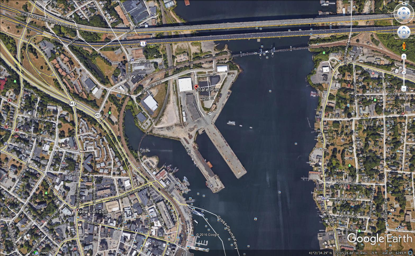
4. Notice of Scoping for State Pier Complex Improvements
Municipality where proposed project might be located: New London
Address of Possible Project Location: 200 State Pier Road, New London, CT. 06320
Project Description: The Department of Economic & Community Development upon the request of the Connecticut Port Authority has prepared this scoping notice. The Connecticut Port Authority is currently conducting a planning/design study related to the improvements needed at the State Pier Complex. The State Pier facility contains approximately 4,000 linear feet of dockage along its two main piers, on-dock rail connectivity to the New England Central Railroad (now owned by Genesee & Wyoming) system, 200,000 square feet of warehouse space, deep water access, and direct connection to the interstate highway system. The site is generally known as the State Pier Complex, which not only includes waterfront features such as piers and quay walls but also includes upland areas straddling State Pier Road and land north of the Gold Star Bridge.
In 2011, the State Pier Needs and Deficiency Planning Study was commissioned by the Connecticut Department of Transportation (CTDOT) to identify site-related and infrastructure repairs and improvements that would better position the facility to capture emerging East Coast shipping opportunities and accommodate some of the logistics generated by the $5 billion in cargo flow annually in Connecticut.
The existing physical plant was found generally to be in good condition relative to similar New England ports with some exceptions. Some of State Pier's greatest constraints are the limited near dock surface area available for cargo moves and laydown area and poor surface conditions. Dredging to achieve uniform depths for both piers and the poor structural and overall condition of the Central Vermont Railroad (CVRR) Pier are among the most challenging deficiencies that need to be remedied.
CTDOT has elected to proceed with preliminary design of improvements generally as outlined in the State Pier Needs and Deficiencies Study. The current design phase includes due diligence, development and evaluation of alternatives, and preliminary engineering followed by preliminary design. Due diligence includes:
- Site visits
- Subsurface soils investigations, both upland and in-water
- Structure inspections, including underwater
- Topographic survey (by CTDOT)
- Hydrographic survey
- Utility mapping
- Review of available environmental data for dredge materials
- Identification and mapping of regulatory limits
Assessment of alternatives involved structure rehabilitation options along with various upland grading schemes and site layout scenarios. Preliminary Design plans generally depict:
-
Site layout and circulation
-
Location of buildings, drives, parking, etc.
-
Access road design
-
Site security provisions
-
Site grading, retaining walls, and drainage
-
Structure rehabilitation plans and details
-
Dredge plans
-
Schematic utility and illumination layout
-
Track restoration layout and details
The Preliminary Design submission represents deliverables essentially considered 35% complete, which shall be submitted and reviewed by CTDOT. The goal of the 35% design is to further develop the project in an effort to better understand opportunities, impacts, and costs. This report is intended to address environmental, utility, right-of-way, and other constraints and needs. The Preliminary Design submission also includes an engineer's opinion of probable construction costs and will serve to further discussions with CTDOT relative to phasing the work.
Project Map(s): Click here to view a map of the project area. Click here to view an aerial photo of the State Pier.
Written comments from the public are welcomed and will be accepted until the close of business on: June 16, 2017
Any person can ask the sponsoring agency to hold a Public Scoping Meeting by sending such a request to the address below. If a meeting is requested by 25 or more individuals, or by an association that represents 25 or more members, the sponsoring agency shall schedule a Public Scoping Meeting. Such requests must be made by May 26, 2017.
Additional information about the project can be viewed online at the Connecticut Port Authority Website: www.portsct.com
Written comments and/or requests for a Public Scoping Meeting should be sent to
| Mr. Joseph Salvatore | |
|
Connecticut Port Authority |
|
|
505 Hudson Street - 3rd Floor |
|
| E-Mail: | joseph.salvatore@ct.gov |
5. Notice of Scoping for Briar Cliff Booster Station and Long Meadow Water Main Extension
Municipality where proposed project might be located: Bethel
Address of Possible Project Location: Nashville Road, Briar Cliff Manor and Long Meadow Lane
Project Description: The Bethel Water Department is currently under a consent order with the Connecticut Department of Public Health (DPH) to provide adequate pressure to the Briar Cliff Manor neighborhood. The Town of Bethel has applied for funding through the Drinking Water State Revolving Fund to install a booster pump station at the intersection of Nashville Road and Briar Cliff Manor to address low system pressures at the customer services on Briar Cliff Manor, Crestview Drive, and Long Meadow Lane. The underground booster pump station is designed to increase pressures above the 25 psi minimum pressure, as required by the Regulations of Connecticut State Agencies. In addition, construction of the proposed project would ensure adequate firefighting flows for the neighborhood. The project also includes the installation of approximately 600 feet of new 8" distribution water main from Briar Cliff Manor to Long Meadow Lane. The installation of the water main in Long Meadow Lane will allow the properties currently connected directly to the transmission main to reconnect to the properly pressurized water main via new service lines.
Project Map: Click here to view a map of the project area.
Written comments from the public are welcomed and will be accepted until the close of business on: June 17, 2017.
Any person can ask the sponsoring agency to hold a Public Scoping Meeting by sending such a request to the address below. If a meeting is requested by 25 or more individuals, or by an association that represents 25 or more members, the sponsoring agency shall schedule a Public Scoping Meeting. Such requests must be made by May 26, 2017.
Written comments and/or requests for a Public Scoping Meeting should be sent to
| Name: | Mr. Eric McPhee |
| Department of Public Health
Drinking Water Section
|
|
|
410 Capitol Avenue, MS #12DWS
PO Box 340308
Hartford, CT 06134-0308
|
|
| Fax: | 860-509-7359 |
| E-Mail: | Dph.sourceprotection@ct.gov |
If you have questions about the public meeting, or other questions about the scoping for this project, contact:
| Name: | Ms. Patricia Bisacky |
|
Department of Public Health
Drinking Water Section
|
|
|
410 Capitol Avenue, MS #12DWS
PO Box 340308
Hartford, CT 06134-0308
|
|
| Phone: | 860-509-7333 |
| Fax: | 860-509-7359 |
| E-Mail: | Patricia.bisacky@ct.gov |
1. Post-Scoping Notice for Montgomery Mills Redevelopment Project, Windsor Locks
Municipality where project will be located: Windsor Locks, CT
CEPA Determination:
On November 8, 2016, the Connecticut Department of Economic and Community Development (DECD) and the Connecticut Department of Housing (DOH) jointly published a Notice of Scopingto solicit public comments for this project in the Environmental Monitor. During the scoping period, the DECD received comments from the Department of Public Health (Drinking Water Section) and (Environmental Health Section); the Department of Energy and Environmental Protection, and the State Historic Preservation Office.
The DECD and the DOH have taken those comments into consideration and have concluded that the project does not require the preparation of Environmental Impact Evaluation under CEPA.
The agency's conclusion is documented in a Memo of Findings and Determination and Environmental Assessment Checklist.
If you have questions about the project, you can contact the agency at:
|
|
Binu Chandy |
|
|
CT Dept. of Economic and Community Development |
|
|
505 Hudson Street, Hartford CT 06106 |
|
|
860.270.8154 |
|
|
860.706.5740 |
|
|
What happens next: The DECD and DOH expect the project to go forward. This is expected to be the final notice of the project to be published in the Environmental Monitor.
After Scoping, an agency that wishes to undertake an action that could significantly affect the environment must produce, for public review and comment, a detailed written evaluation of the expected environmental impacts. This is called an Environmental Impact Evaluation (EIE).
1. Notice of Public Hearings for
Environmental Impact Evaluation and Environmental Assessment
Re: Tree Obstruction Removal at Hartford-Brainard Airport
Municipality where project is proposed: The Harford-Brainard Airport is located in the City of Hartford approximately two miles southeast of Downtown Hartford, CT.
Address of possible Project Location: The Airport office is located at 251 Maxim Road, just east of Interstate 91 and west of the Connecticut River.
Project Description: Preparation of National Environmental Policy Act (NEPA) and Connecticut Environmental Policy Act (CEPA) environmental documents as required to evaluate the potential impacts associated with tree obstruction removal in areas on, as well as north, south, east and west of the Hartford-Brainard Airport. The evaluation addresses obstruction removals associated with Federally-defined airspace surfaces surrounding the airport needed for the continued safe operation of aircraft. Objects that penetrate these surfaces are classified as obstructions, and should be removed to safely accommodate approaching and departing aircraft.
The project sponsoring agencies, the Connecticut Airport Authority (CAA) and the Federal Aviation Administration (FAA), have identified that trees penetrate the airspace at the Airport, including locations beyond the southern airport property boundary. Per FAA and CAA practice, review of off-airport obstruction removal should be evaluated and documented via a NEPA Environmental Assessment (EA) and State CEPA Environmental Impact Evaluation (EIE). This project includes the identification of each affected property owner and associated parcels (both public and private) with anticipated obstruction removals.
The Connecticut Airport Authority (CAA) will be holding three (3) Public Hearings on the Hartford-Brainard Airport draft Federal Environmental Assessment (EA) and State Environmental Impact Evaluation (EIE) for Tree Clearing. At these meetings, information on the overall project and the study’s findings, including the Preferred Alternative, will be presented. The doors for all meetings will open at 6:30 PM with each public hearing beginning at 7:00 PM.
Public Hearings will be held at the following locations on the specified dates:
Meeting 1- Hartford:
Tuesday, April 18, 2017
Bulkeley High School (300 Wethersfield Ave., Hartford, CT 06114)
Meeting 2- Glastonbury:
Wednesday, April 19, 2017
Glastonbury Town Hall, Council Chambers (2155 Main St., Glastonbury, CT 06033)
Meeting 3-Wethersfield:
Thursday, April 27, 2017
Wethersfield Town Hall (505 Silas Deane Hwy., Wethersfield, CT 06109)
NOTES: Free language assistance or sign interpretation may be requested by contacting Colin Goegel at the address below at least five (5) business days prior to the meeting. Efforts will be made to respond to requests for assistance.
The public can view a copy of the draft EIE/EA on the project website at: http://hartfordairport.caa-analysis.com/, and at the following locations:
Hartford Public Library
500 Main Street
Hartford, CT 06103
Wethersfield Public Library
515 Silas Deane Hwy
Wethersfield, CT 06109
East Hartford Public Library
840 Main Street
East Hartford, CT 06108
Welles-Turner Memorial Library
2407 Main Street
Glastonbury, CT 06033
Send your comments or questions about the draft EIE/EA: 1) via the project website listed above, or 2) to Mr. Colin Goegel at the mailing address or e-mail below:
Name: Mr. Colin Goegel, Supervising Engineer
Agency: Connecticut Airport Authority
334 Ella Grasso Turnpike, Suite 160
Windsor Locks, CT 06096
Phone: (860) 254-5628
E-Mail: cgoegel@ctairports.org
Comments on the draft EIE/EA will be accepted until the close of business on:
Monday, May 22, 2017.
2. Notice of EIE forState Office Building Redevelopment (BI-2B-381)
Municipality where project is proposed: Hartford
Address of Possible Project Location(s): 165 Capitol Avenue and 309 Buckingham Street, Hartford
- A complete interior renovation of the existing 321,493 gross square foot State Office Building (SOB) which was built in 1931, restoration and renovation of the building exterior, renovation of the central exterior courtyard, and reconfiguration of the existing building entrances. Site work includes the creation of a landscaped plaza, redevelopment of existing perimeter streetscape and redevelopment of the existing surface parking lot. The renovation would support a similar number of employees (approximately 900) as the current use.
- Demolition of the existing 450-car parking structure and the 309 Buckingham Trade ("maintenance") Shop located at the corner of Washington and Buckingham Streets,* with construction of an approximate new 1,050-space parking structure. An option under consideration is to provide retail space along Washington Street as part of the overall parking structure. The remaining green space at the corner of Washington and Buckingham Streets would be a landscaped park-like area.
Project Map(s): Click here to view the general location (1.1 MB). Click here to view a figure of the project area (6.1 MB). Click here to view the site plan(213 KB)
Comments on this EIE will be accepted until the close of business on: June 2, 2017
No public hearing is scheduled for this EIE. A public hearing request must be made by twenty-five persons or an association having not less than twenty-five persons. Such requests must be made by the close of business on and no later than April 28, 2017 by 5:00 pm.
Send your comments about this EIE to:
| Name: | Jeff Bolton, Supervising Environmental Analyst |
| Agency: | Department of Administrative Services |
| Address: | 450 Columbus Blvd., Suite 1305, Hartford, Connecticut 06103 |
| E-Mail: | Jeffrey.bolton@ct.gov |
| Name: | Jeff Bolton, Supervising Environmental Analyst |
| Agency: | Department of Administrative Services |
| Address: | 450 Columbus Blvd., Suite 1305, Hartford, Connecticut 06103 |
| E-Mail: | Jeffrey.bolton@ct.gov |
| Phone: | 860-713-5706 |
3. Notice of EIE for Orange Commuter Rail Station
Project Title: Orange Railroad Station, New Haven Line
Project Description: The Connecticut Department of Transportation (CTDOT) is proposing to construct a new commuter railroad station along the New Haven Line in Orange, Connecticut through a public-private partnership that will include a Transit Oriented Development (TOD). The Orange Railroad Station is proposed to include the following elements:
- Two new, approximately 1,020-foot long and approximately 10-foot wide canopied station platforms, one of the eastbound side and one on the westbound side
- A covered pedestrian bridge connecting the platforms via stairtowers and elevators
- A gated emergency access driveway
- Commuter drop-off / pick up, taxi stand and bus stop areas
- A 6-level, 566-space commuter parking structure that will serve the rail station
- Stormwater management system
- Utility infrastructure
- Improvements / extension of the existing Salemme Lane and cul-de-sac terminating at the new station
Project Map: Click here to view a map of the project area.
The public can view a copy of this EIE at: The Connecticut Department of Transportation Bureau of Policy and Planning (Room 2155), 2800 Berlin Turnpike, Newington, CT; Case Memorial Library, 176 Tyler City Road, Orange, CT 06477; and Orange Town Hall, Town Clerk's Office, 617 Orange Center Road, Orange, CT 06477
DATE: Tuesday June 20, 2017
TIME: Doors open at 6:30 p.m., a presentation will begin at 7:00 p.m.
PLACE: High Plains Community Center Gymnasium, 525 Orange Center Road, Orange, CT 06477
NOTES: The meeting facility is ADA accessible. Deaf, hearing impaired persons, and those with Limited English Proficiency may request language assistance by contacting the Department's Office of Communications at (860) 594-3062 at least five (5) business days prior to the meeting. Persons having a hearing and/or speech disability may dial 711 for Telecommunications Relay Service (TRS) to request assistance. Language assistance is provided at no cost to the public.
The EIE is available electronically by clicking here
The EIE is also available online at: www.ct.gov/environmentaldocuments
| Name: | Mr. Mark F. Carlino, P.E., Transportation Planning Director |
| Agency: | Connecticut Department of Transportation, Bureau of Policy and Planning |
| Address: | 2800 Berlin Turnpike, Newington, CT 06131 |
| E-Mail: | dot.EnvironmentalPlanning@ct.gov |
If you have questions about the public hearing, or where you can review this EIE, or similar matters, please contact:
| Name: | Mr. Kevin C. Fleming, Transportation Planner |
| Agency: | Connecticut Department of Transportation, Bureau of Policy and Planning |
| Address: | 2800 Berlin Turnpike, Newington, CT 06131 |
| E-Mail: | |
| Phone: | 860-594-2924 |