
River and Stream Water Monitoring
River and Stream Water Quality Monitoring
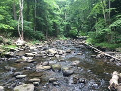
DEEP has monitored rivers and streams for water quality since the 1970s. Current annual monitoring efforts include the collection of water chemistry, water temperature, macroinvertebrate community, fish community, diatom community, and indicator bacteria data from locations throughout the State.
These data are used to assess the health of individual waterbodies. In addition, the data are used to support a variety of other projects, including evaluation of trends in Connecticut’s water quality in the state, study of the potential impacts of climate change on our waterbodies, and supporting nutrient and temperature criteria development.
Monitoring Program Design
The Monitoring Group works hard to collect data on as many of the state’s rivers and streams as possible each year. This is a challenge as there are approximately 7,772 miles of rivers and streams within Connecticut. This is longer than the US-Mexico and US-Canada borders combined! Therefore, we use a combination of targeted monitoring and probabilistic monitoring to assess the State’s waters in order to achieve the greatest monitoring coverage possible.
Targeted Monitoring
Targeted monitoring involves the monitoring of locations selected to answer specific questions regarding status and trends, identification of healthy and impaired waters, pollution control effectiveness, damage assessment, waste load allocations, and stressor identification at predetermined locations. This type of monitoring generates information that is waterbody specific and is an essential component of Connecticut’s water resource management activities.
Targeted monitoring locations include those identified within either the Rotating Basin Monitoring Framework or the Stream Sampling Network.
Rotating Basin Monitoring Framework
A five-year Rotating Basin Monitoring Framework has been utilized by the Water Monitoring Group since 1996. The rotating basin approach is a targeted monitoring approach that uses Connecticut's eight major drainage basins - Pawcatuck, Southeast Coast, Thames, Connecticut, South Central Coast, Housatonic, Southwest Coast, and Hudson - as a hydrological framework to organize monitoring and assessment work.
Using this approach, the Monitoring Group is able to sample approximately 350 river and stream sites statewide during each five-year rotation. The rotating basin ensures statewide coverage of surface waters for assessment with the goal of completing all eight major basins every 5 years. In addition, the approach provides a predictable schedule that can enhance collaboration with other programs.
Stream Sampling Network
The Monitoring Group has identified a collection of sites to serve as a long-term Stream Sampling Network. Collectively, these Stream Sampling Network sites were chosen to provide statewide coverage, represent the range of watershed sizes in Connecticut, and the range of disturbance conditions in the state. Percent impervious land cover in the watershed was used as a surrogate measure for disturbance. Biological monitoring at these sites is a high priority; the Monitoring Program strives to sample each location annually for macroinvertebrates and every 3-5 years for fish.
Twenty three 'least disturbed' sites, characterized by less than 4% impervious cover in the upstream watershed, were selected for inclusion in the network. These sites serve as ‘sentinel sites,’ representing a subnetwork of long-term ‘healthy’ stream sites and are an important component of the Monitoring Group's Healthy Waters Initiative. Three of these sentinel sites serve as project sites for the Northeast Regional Monitoring Network (RMN) to Detect Climate Change Effects in Stream Ecosystems Project. The data collected at these sites will be used to detect trends over time in stream health, not just in Connecticut, but across the northeastern U.S.
Probabilistic Monitoring
Unlike targeted monitoring locations, sampling locations selected for probabilistic monitoring are chosen randomly using a statistical design. Since it is not possible to monitor “everywhere all the time”, probabilistic monitoring is used to help answer questions such as, “What percent of the streams in Connecticut are healthy?" and "What percent of the stream in Connecticut are impaired for aquatic life use support?” Probabilistic surveys are conducted on a five-year cycle allowing for continual reassessment of the overall condition of the state’s waters.
In addition, to these five-year probabilistic surveys, since 2006 DEEP has also participated in the U.S. Environmental Protection Agency National Rivers and Streams Assessment (NRSA). Similar to the Connecticut probabilistic monitoring surveys, the NRSA surveys are conducted throughout the United States allowing for a scientifically-defensible overall assessments of the nation’s waters.
Project-Specific Information
For more detailed information about how DEEP monitors rivers and streams please explore the following project pages:
- Ambient Biological Monitoring:
- Streamflow Monitoring
- Temperature Monitoring
- Tissue Contaminant Monitoring
- Volunteer Monitoring (Citizen Science) Programs:
Related Pages
- Water Monitoring Program Overview
- Biennial Integrated Water Quality Report to Congress
- Streamflow Standards and Regulations
- Watershed Management Program
- Integrated Water Resource Management
- Water Use and Discharge Regulation
- Dams and Dam Safety
- Flood Management and Natural Hazard Mitigation
Program Contact Information
79 Elm Street, Hartford CT 06106
DEEP.watermonitoring@ct.gov
Content last revised December 20, 2022.