
State Dams and Dam Safety
Dams
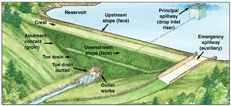
What is a dam?
Dams are man-made or artificial barriers (earth or combinations of earth and other materials) usually constructed across a stream channel to impound water. Dams provide a range of economic, environmental, and social benefits, including recreation, flood control, water supply, hydroelectric power, waste management, river navigation, and wildlife habitat.
Dams are typically provided with spillway systems constructed of non-erosive materials such as concrete or rock to safely pass a broad range of flows over, around or through the dam.
Dams are typically constructed with a drain or similar mechanism to control water levels in an impoundment for normal maintenance or emergency purposes.
State-Owned Dams and Flood Control Systems - Information on dams owned by the State of Connecticut and ongoing project updates.
Dam Safety Regulatory Program - All dams in the State of Connecticut (which are not otherwise regulated by the Federal Energy Regulatory Commission, the United States Army Corps of Engineers, or a local municipality) are governed by the Dam Safety Regulatory Program.
Public Safety - Be aware of boating or swimming near low head dams!
Additional References:
Weather
NOAA National Weather Service– Comprehensive weather information
Intellicast - Commercial weather site
Accuweather – Commercial weather site
Precipitation
NOAA Atlas 14 for the northeast is now available.
Precipitation frequency estimates for CONNECTICUT updated 9-30-2015
Current NWS Probable Maximum Precipitation (PMP) Documents
NOAA Precipitation History – 24 hour and weekly accumulations
Intellicast 24-hour precipitation accumulation
River Information
NOAA River Gauge – Real time river data with hydrographs
USGS Water Watch – Maps of high flow and flooding locations, and real-time stream flow