
Environmental Monitor Archives - March 5, 2019

- Bridgeport Municipal Airport Improvements, Stratford
- Resilient Bridgeport, Bridgeport
- Parcels on Waterfront, Albia, Alabama, and Edgemere Streets, New Haven
"Scoping" is for projects in the earliest stages of planning. At the scoping stage, detailed information on a project's design, alternatives, and environmental impacts does not yet exist. Sponsoring agencies are asking for comments from other agencies and from the public as to the scope of alternatives and environmental impacts that should be considered for further study. Send your comments to the contact person listed for the project by the date indicated.
1. Notice of Scoping for Bridgeport Municipal Airport Improvements
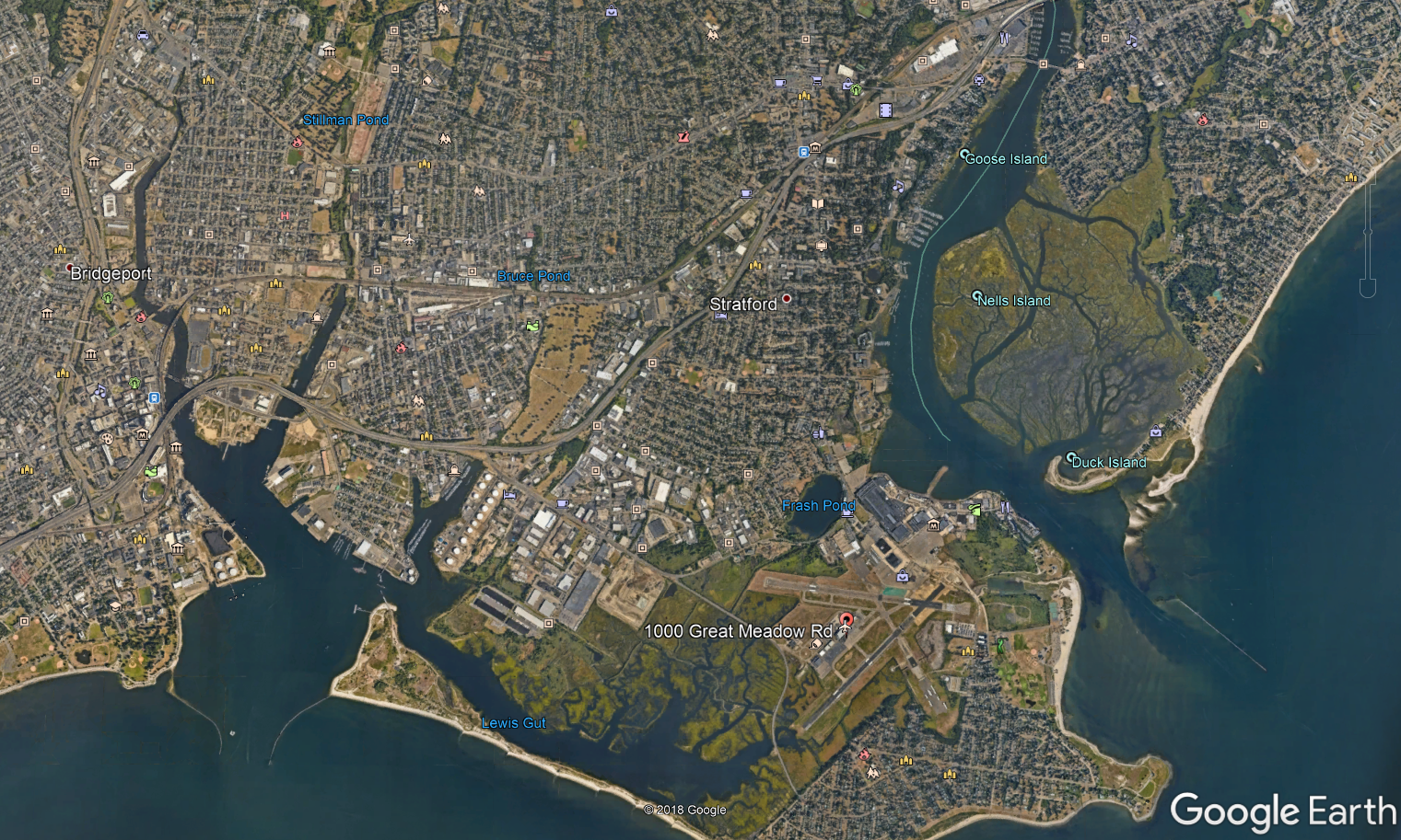
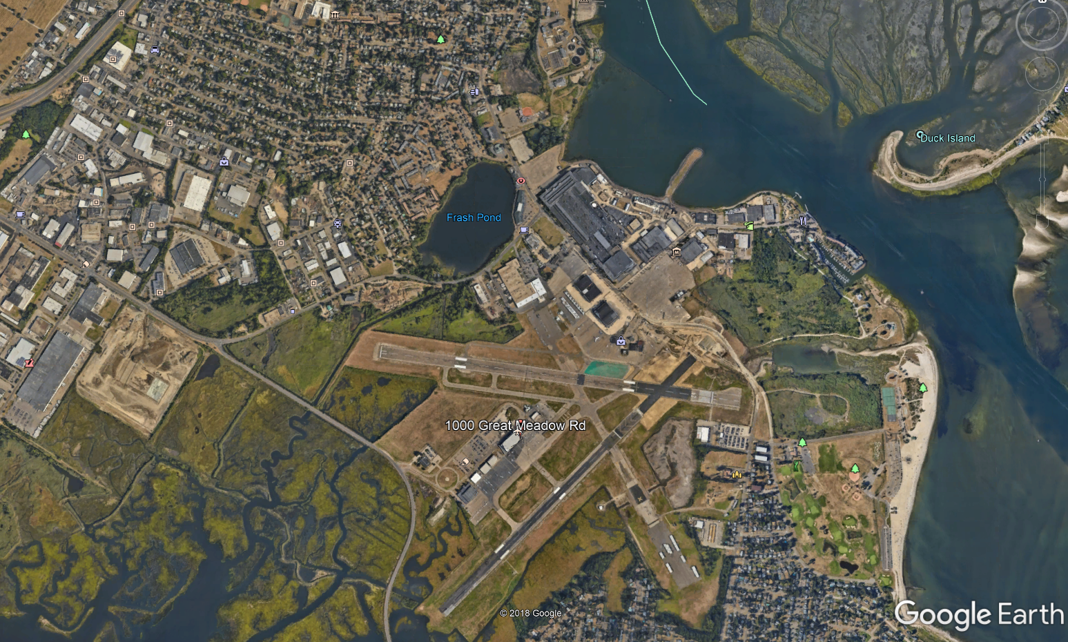
Municipality where proposed project might be located: Stratford
Address of project location: 1000 Great Meadow Road
Project Description: The Department of Economic and Community Development is proposing to provide financial assistance to the City of Bridgeport as a 47% match to a private investment to assist in the construction of the Phase I improvements at the Bridgeport Municipal/ Sikorsky Memorial Airport (BDR) in the Town of Stratford. The proposed project is intended to initiate commercial airline service to BDR. The mid-range airline service along the U.S. eastern seaboard is expected to start in 2020, with approximately 5 to 8 flights daily. The proposed aircraft fleet is quieter than many corporate aircraft currently operating at the airport today. The capacity of the aircraft is approximately 100 to 150 passengers.
The proposed project will include improvements to the airport’s taxiways, runways, parking lots, construction of an approximate 20,000 sf terminal building to be used as a holding area and support space for office, ticketing, freight, baggage, and concessions. The project may also include the rehabilitation of an existing 8,000 sf existing abandoned structure to be reused as an operations center. This proposed project is consistent with the Airport Layout Plan (ALP) approved by the FAA in 2009.
The project developer will be providing the matching funds needed to complete the project. The necessary financial commitments and assurances will be in place prior to any State funding disbursement.
Project Maps: Click here to view a location map of the project area. Click here to view a site plan.
Written comments from the public are welcomed and will be accepted until the close of business on March 21, 2019.
Any person can ask the sponsoring agency to hold a Public Scoping Meeting by sending such a request to the address below. If a meeting is requested by 25 or more individuals, or by an association that represents 25 or more members the sponsoring agency shall schedule a Public Scoping Meeting. Such requests must be made by March 6, 2019.
Written comments and/or requests for a Public Scoping Meeting should be sent to:
Christine Marques
Office of Capital Projects
Department of Economic and Community Development
450 Columbus Blvd, 4th floor, Hartford CT 06103
If you have any questions concerning the scoping of this project or a public meeting please contact:
Christine Marques
Office of Capital Projects
Department of Economic and Community Development
450 Columbus Blvd, 4th floor, Hartford CT 06103
Christine.marques@ct.gov
After Scoping, an agency that wishes to undertake an action that could significantly affect the environment must produce, for public review and comment, a detailed written evaluation of the expected environmental impacts. This is called an Environmental Impact Evaluation (EIE).
1. Notice of EIE for Resilient Bridgeport: Rebuild By Design and National Disaster Resilience Projects
Municipality where project is proposed: Bridgeport
Address of Possible Project Location: South End of Bridgeport, CT
Project Description: The State of Connecticut’s Department of Housing (CTDOH) is the recipient of the U.S. Department of Housing and Urban Development (HUD) disaster recover grant funding and is the “Responsible Entity,” as that term is defined by HUD regulations at 24 Code of Federal Regulations (CFR) Part 58.2(a)(7)(i). CTDOH has prepared a Draft Environmental Impact Evaluation (EIE) for the proposed Resilient Bridgeport: National Disaster Resilience and Rebuild by Design projects (Proposed Action). The disaster recovery grants are under HUD’s Community Development Block Grant Disaster Recovery (CDBG-DR) National Disaster Resilience (NDR) and Rebuild by Design (RBD) programs as part of HUD’s response to the devastation following Superstorm Sandy. The Proposed Action consists of three projects located within the South End of Bridgeport, Connecticut—the RBD Pilot Project at the former Marina Village public housing site, a Flood Risk Reduction Project on the east side of the South End, and a Resilience Center—that together would provide stormwater management, dry evacuation routes (dry egress), a coastal flood defense system, and resiliency education to the community.
The Connecticut Environmental Policy Act establishes environmental policy for the State of Connecticut and requires an EIE for any state action that could affect the natural environment. In addition, the Proposed Action is considered a “major federal action significantly affecting the quality of the human environment”; therefore, it must comply with the requirements of the National Environmental Policy Act of 1969 (NEPA). As such, this EIE will jointly serve as an EIS and will meet NEPA requirements. CTDOH has prepared this Draft EIS/EIE in accordance with the Council on Environmental Quality’s Regulations for Implementing the Procedural Provisions of NEPA (40 CFR Parts 1500-1508) and HUD’s Environmental Review Procedures for Entities Assuming HUD Environmental Responsibilities (24 CFR 58). Scoping for the Draft EIS / EIE formally began on February 27, 2018 when the Notice of Intent to Prepare an EIS was published in the Connecticut Environmental Monitor, which commenced a 30-day comment period to solicit public and agency input that lasted through March 28, 2018 and included a public scoping hearing on March 14, 2018.
The study area is situated within the South End neighborhood of the City of Bridgeport (see linked Figures 1 and 2), a peninsula of the Connecticut coastal region located between Cedar Creek, the Long Island Sound, and Bridgeport Harbor. Overall, the study area is a cross section of the residential, institutional, utility, and recreational uses that define the South End neighborhood, all of which are susceptible to acute and chronic flooding conditions due to a combination of inadequate stormwater infrastructure in the area and its coastal location.
The purpose of the Proposed Action is to create a more resilient South End community, support its long-term viability, and improve health and safety for the community’s vulnerable populations. The principal targeted outcomes follow:
- Lower the risk of acute and chronic flooding.
- Provide dry egress during emergencies.
- Educate the public about flood risks and sea level rise.
The Proposed Action will deliver additional benefits to the community, potentially unlocking development or public realm opportunities, enhancing connectivity between the South End and downtown Bridgeport (located north of the railroad and I-95), improving existing open space amenities, building up the resilience of local energy systems, and leveraging public investment in ongoing resiliency efforts through coordination with local stakeholders.
Project Maps:
Figure 2 – Project Location Map
Comments on this EIE will be accepted until the close of business on: March 18, 2019. The comment period for the CEPA was extended to the end of the 45-day NEPA comment period, which commenced on February 1, 2019 with the publication of the notice in the Federal Register.
The public can view a copy of this EIE at:
Bridgeport City Hall
45 Lyon Terrace
Bridgeport, CT 06604
(203) 576-7081
Bridgeport Public Library Main Branch
925 Broad Street
Bridgeport, CT 06604
(203) 576-7400
Bridgeport Public Library Black Rock Branch
2705 Fairfield Avenue
Bridgeport, CT 06605
(203) 576-7025
University of Bridgeport Magnus Wahlstrom Library
126 Park Avenue
Bridgeport, CT 06604
(203) 576-2388
Project Document Website at the Connecticut Department of Housing:
https://www.ct.gov/doh/cwp/view.asp?a=4513&q=588726
Project Documents Direct Links:
DEIS / EIE Document Appendices
There will be a public informational workshop for this EIE on:
DATE: February 26, 2019
TIME: 6:00 p.m. to 8:00 p.m.
PLACE: Schelfhaudt Gallery (84 Iranistan Avenue, Bridgeport, CT)
NOTES: This hearing serves as the public hearing required under NEPA. The public hearing will be followed by a design workshop where the public can provide further input into the design of the Resilient Bridgeport projects. The snow date for the public hearing and workshop is February 28, 2019.
Additional information about this project can be found online at:
https://www.ct.gov/doh/cwp/view.asp?a=4513&q=588726 and www.resilientbridgeport.com
Send your comments about this EIE to:
|
Name: |
Rebecca French, Director of Resilience |
|
Agency: |
Connecticut Department of Housing |
|
Address: |
505 Hudson Street, Hartford, CT 06106 |
|
E-Mail: |
Rebecca.French@ct.gov |
If you have questions about the public hearing, or where you can review this EIE, or similar matters, please contact:
|
Name: |
Rebecca French, Director of Resilience |
|
Agency: |
Connecticut Department of Housing |
|
Address: |
505 Hudson Street, Hartford, CT 06106 |
|
E-Mail: |
Rebecca.French@ct.gov |
|
Phone: |
860-270-8231 |
Other information: N/A