
Environmental Monitor Archives - July 2, 2019

- NEW! Chestnut Ridge Storage Tank, Bethel
Post-Scoping Notices: Environmental Impact Evaluation (EIE) Not Required
- Major Intersection Improvements Route 34, Newtown
- REVISED WITH NEW COMMENT DEADLINE AND ONLINE EIE! Connecticut Training Center Real Property Master Plan EIE/EA, East Lyme, Lyme, Old Lyme, and East Haven
- Proposed Land Transfer #0 Riverside Drive, Milford
"Scoping" is for projects in the earliest stages of planning. At the scoping stage, detailed information on a project's design, alternatives, and environmental impacts does not yet exist. Sponsoring agencies are asking for comments from other agencies and from the public as to the scope of alternatives and environmental impacts that should be considered for further study. Send your comments to the contact person listed for the project by the date indicated.
1. Notice of Scoping for Chestnut Ridge Storage Tank
Municipality where proposed project might be located: Bethel
Address of Possible Project Location: Between 27 Long Meadow Lane and 22 Briar Cliff Manor
Project Description: The Town of Bethel proposes to construct a new 500,000 gallon concrete water storage tank. The proposed tank will be 65-feet in diameter with an approximate height of 21-feet above grade. An electrical and instrumentation enclosure will also be located near the tank. This project supports Bethel's long term plan to replace its existing surface water supplies and treatment plants with ground water supplies by increasing the Town's overall storage capacity as indicated in Town's Water Supply Plan. The Chestnut Ridge Storage Tank will provide the needed additional emergency and fire protection storage, redundancy and backup to the Eureka Lake Water Storage Tank.
Project Map: Click here to view a map of the project area.
Written comments from the public are welcomed and will be accepted until the close of business on: August 2, 2019.
Any person can ask the sponsoring agency to hold a Public Scoping Meeting by sending such a request to the address below. If a meeting is requested by 25 or more individuals, or by an association that represents 25 or more members, the sponsoring agency shall schedule a Public Scoping Meeting. Such requests must be made by July 12, 2019.
Written comments and/or requests for a Public Scoping Meeting should be sent to
| Name: | Mr. Eric McPhee |
| Agency: |
Department of Public Health
Drinking Water Section
|
| Address: |
410 Capitol Avenue, MS #12DWS
PO Box 340308
Hartford, CT 06134-0308
|
| Fax: | 860-509-7359 |
| E-Mail: | Dph.sourceprotection@ct.gov |
If you have questions about the public meeting, or other questions about the scoping for this project, contact:
| Name: | Ms. Patricia Bisacky |
| Agency: |
Department of Public Health
Drinking Water Section
|
| Address: |
410 Capitol Avenue, MS #12DWS
PO Box 340308
Hartford, CT 06134-0308
|
| Phone: | 860-509-7333 |
| Fax: | 860-509-7359 |
| E-Mail: | Patricia.bisacky@ct.gov |
Inquiries and requests to view and or copy documents, pursuant to the Freedom of Information Act, must be submitted to the sponsoring State Agency:
|
Name: |
Mr. Av Harris |
|
Agency: |
Department of Public Health
|
|
Address: |
410 Capitol Avenue, MS #13CMN Hartford, CT 06134-0308 |
|
E-Mail: |
DPH.foi@ct.gov |
|
Phone: |
860-509-7286 |
This category is required by the October 2010 revision of the Generic Environmental Classification Document for State Agencies. A notice is published here if the sponsoring agency, after publication of a scoping notice and consideration of comments received, has determined that an Environmental Impact Evaluation (EIE) does not need to be prepared for the proposed project.
1. Post-Scoping Notice for Intersection Improvements on Route 34 at SR 490 (Wasserman Way) and Toddy Hill Road and SR 490 at I-84 Interchange 11 ramps.
Municipality where project will be located: Newtown
CEPA Determination: On April 19, 2016 the Connecticut Department of Transportation (CTDOT) published a Notice of Scoping to solicit public comments for this project in the Environmental Monitor. During the scoping period, CTDOT received comments from the Office of Policy and Management (OPM), the Connecticut Department of Energy and Environmental Protection (CTDEEP), and the Department of Public Health (DPH) Drinking Water Section. CTDOT has taken all comments into consideration and has concluded that the project does not require the preparation of Environmental Impact Evaluation under CEPA.
The agency's conclusion is documented in a Memo of Findings and Determination and Environmental Assessment Checklist.
If you have questions about the project, you can contact the agency at:
Name: Kevin Fleming, Transportation Planner II
Agency: Connecticut Department of Transportation, Office of Environmental Planning
Address: 2800 Berlin Turnpike, Newington, CT 06131
Phone: (860) 594-2924
E-Mail: Kevin.Fleming@ct.gov
What happens next: The CTDOT expects the project to go forward. This is expected to be the final notice of the project to be published in the Environmental Monitor.
After Scoping, an agency that wishes to undertake an action that could significantly affect the environment must produce, for public review and comment, a detailed written evaluation of the expected environmental impacts. This is called an Environmental Impact Evaluation (EIE).
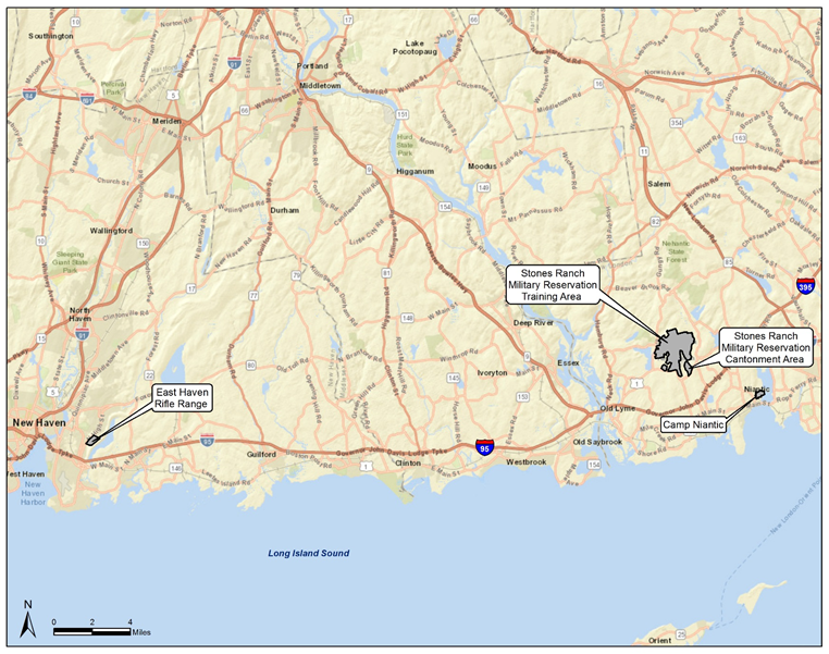
1. Final Environmental Assessment (EA) for Approval of the Connecticut Training Center Real Property Master Plan of the Connecticut Army National Guard
Municipalities where proposed project might be located: East Lyme, Lyme, Old Lyme, and East Haven
Address of Possible Project Location: Stones Ranch Military Reservation, 10 Stone Ranch Road, East Lyme, CT 06333; Camp Niantic, 38 Smith Street, Niantic, CT 06357; East Haven Rifle Range, 591 N. High Street, East Haven, CT 06512
Project Description: The Connecticut Military Department/Connecticut Army National Guard (CTARNG) proposes to approve a new Real Property Master Plan (RPMP) for the Connecticut Training Center (CTC) consistent with the requirements of the US Department of Defense (DoD) Unified Facilities Criteria (UFC) 2-100-01, Installation Master Planning, which provides guidance for developing RPMPs for DoD installations. The Environmental Assessment (EA) evaluates the potential environmental, cultural, and socioeconomic effects of approving the UFC 2-100-01-compliant RPMP. The CTC comprises three noncontiguous installations: Stones Ranch Military Reservation, Camp Niantic, and East Haven Rifle Range. The RPMP is needed to comply with DoD Master Planning policy as well as to guide the CTARNG through the long-term development of the CTC in a clear, sustainable manner that supports the installations’ military missions. The Proposed Action would provide an updated master plan to guide the CTARNG’s mission at the CTC for the next 20 years using the latest techniques in planning.
Project Map: See Map.
Written comments from the public are welcomed and will be accepted until the close of business on: July 19, 2019.
The public can view a copy of this EIE here, or at the locations listed below, where it will be available from June 5, 2019:
- CTARNG Public Affairs Office, 360 Broad Street, Hartford, CT 06105
- East Lyme Public Library, 39 Society Road, Niantic, CT 06357
- Lyme Public Library, 482 Hamburg Road, Lyme, CT 06371
- Old Lyme Phoebe Griffin Noyes Library, 2 Library Lane, Old Lyme, CT 06371
- Hagaman Memorial Library, 227 Main Street, East Haven, CT 06512
If a public hearing is requested by 25 or more individuals, or by an association that represents 25 or more members, the sponsoring agency shall schedule a hearing. Such requests must be made by: June 28, 2019.
Written comments and/or requests for a Public Hearing should be sent to:
|
Name: |
Mr. Robert Dollak, Environmental Program Manager |
|
Agency: |
Connecticut Military Department/Connecticut Army National Guard |
|
Address: |
360 Broad Street, Hartford CT 06105 |
|
Phone: |
(860) 524-4945 |
|
E-Mail: |
If you have questions about this project, contact:
|
Name: |
Mr. Robert Dollak, Environmental Program Manager |
|
Agency: |
Connecticut Military Department/Connecticut Army National Guard |
|
Address: |
360 Broad Street, Hartford CT 06105 |
|
Phone: |
(860) 524-4945 |
|
E-Mail: |
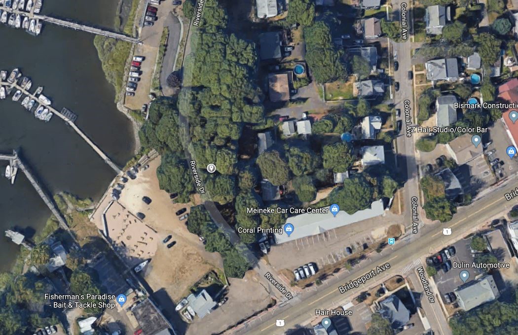
1. NOTICE OF PROPOSED LAND TRANSFER for 0 RIVERSIDE DRIVE, MILFORD, CT 06461
Commonly used name of property or other identifying information: Assessor’s Lot 18-364-15
Number of acres to be transferred: 0.14 Acres
Click to view map of property location
Description of Property
Below is some general information about the property. It should not be considered a complete description of the property and should not be relied upon for making decisions. If only a portion of a property is proposed for transfer, the description pertains only to the portion being transferred.
Brief Description of Historical and Current Uses:
Vacant, nonconforming lot
The property to be transferred contains the following:
|
Structures: |
Buildings in use |
Buildings not in use |
No Structures |
|
Other Features: |
Wooded land |
Nonagricultural fields |
Active agriculture |
|
|
Paved areas |
Ponds, streams, other water, wetlands |
|
|
Water Supply: |
Public water supply |
On-site well |
Unknown |
|
Waste Disposal: |
Served by sewers |
On-site septic system |
Unknown |
Click to view parcel map of property
Click to view photograph of property
The property is in the following municipal zone:
|
Residential |
Industrial |
Commercial |
Institutional |
|
Other: |
|||
|
Not zoned |
Not known |
||
Special features of the property, if known: DEEP Natural Diversity.
Value of property, if known: Unknown
Type of Sale or Transfer:
Sale or transfer of property in fee
Sale or transfer of partial interest in the property (such as an easement).
Proposed recipient, if known: Unknown
Proposed use by property recipient, if known: Unknown
The agency is proposing to transfer the property with the following restrictions on future uses:
If checked, the state is not currently proposing restrictions on future uses.
Reason the State of Connecticut is proposing to transfer this property: Surplus.
Comments from the public are welcome and will be accepted until the close of business on July 5, 2019.
Comments may include (but are not limited to) information you might have about significant natural resources or recreation resources on the property, as well as your recommendations for means to preserve such resources.
Written comments* should be sent to:
|
Name: |
Paul F. Hinsch |
|
Agency: |
Office of Policy and Management |
|
|
Bureau of Assets Management |
|
Address: |
450 Capitol Avenue |
|
|
Hartford, CT 06106-1379 |
|
E-Mail: |
*E-Mail submissions are preferred.
Send copies of comments to:
|
Name: |
Shane Mallory |
|
Agency: |
Department of Administrative Services |
|
|
Statewide Leasing & Property Transfer Unit |
|
Address: |
450 Columbus Boulevard, Suite 1402 |
|
|
Hartford, CT 06103 |
|
E-Mail: |
(Comments from state agencies must be on agency letterhead and signed by agency head. Scanned copies are preferred.)