
February 2, 2016

February 2, 2016
- Replacement of Bridge #03993 - West St., Middletown
- NEW! Cockaponset State Forest Prescribed Burn, Chester and Haddam
- NEW! Construction of Student Recreation Center, Mansfield
No Post Scoping Notice has been submitted for publication in this edition.
- University of Connecticut South Campus Development, Mansfield
- NEW! Four Corners Sewer Extension, Mansfield
"Scoping" is for projects in the earliest stages of planning. At the scoping stage, detailed information on a project's design, alternatives, and environmental impacts does not yet exist. Sponsoring agencies are asking for comments from other agencies and from the public as to the scope of alternatives and environmental impacts that should be considered for further study. Send your comments to the contact person listed for the project by the date indicated.
1. Notice of Scoping for Replacement of Bridge No. 03993 - West Street over Providence & Worcester Railroad
Address of Possible Project Location: West Street (between Middlefield Street and Butternut Street) over Providence & Worcester Railroad
The bridge carries one lane of traffic, and is controlled with an alternating one-way traffic pattern with stop signs at both approaches to the bridge. The existing curb-to-curb width of the bridge is 17 feet, and the estimated 2014 Average Daily Traffic (ADT) on West Street at this site is 4,260 vehicles per day.
The proposed bridge replacement will result in approximately 800-feet of roadway re-construction. The existing vertical under-clearance of 18-feet 1-inch over the railroad at the bridge will be maintained in the proposed condition. The bridge replacement will consist of a new precast concrete deck unit superstructure supported by new concrete abutments, concrete in-line wingwalls, and mechanically stabilized earth walls. The foundation system of the bridge and walls will be constructed to facilitate undercutting (lowering) of the railroad if the tracks are lowered to provide 20-feet 6-inches of under-clearance at the bridge as part of a separate project in the future.
Project Map: Click here to view a map and aerial photograph of the project area.
Written comments from the public are welcomed and will be accepted until the close of business on: Friday February 19, 2016.
Written comments and/or requests for a Public Scoping Meeting should be sent to:
| Name: | Mr. Mark W. Alexander, Transportation Assistant Planning Director |
| Agency: |
Connecticut Department of Transportation
|
|
Address:
|
Bureau of Policy and Planning
2800 Berlin Turnpike, Newington, CT 06131
|
| Fax: | 860-594-3028 |
| E-Mail: |
If you have questions about the scoping for this project, contact:
| Name: | Mr. Louis D. Bacho, Transportation Supervising Engineer |
| Agency: |
Connecticut Department of Transportation
|
| Bureau of Engineering and Construction | |
|
Address:
|
2800 Berlin Turnpike, Newington, CT 06131 |
| Phone: | 860-594-3212 |
| E-Mail: | Louis.bacho@ct.gov |
2. Notice of Scoping for Cockaponset State Forest Prescribed Burn
Municipality where proposed project might be located: Chester and Haddam
Project Location: Cockaponset State Forest, Turkey Hill Block, Compartment 17, West of Filley Road and South of Old County Road.
Project Description: The proposed project is a 197 acre prescribed burn that will consume primarily leaf litter and downed branches. The intent is to partially promote the regeneration of an oak forest. Oak forests are not sustaining themselves under current natural conditions. They were historically sustained after Native American fires, agricultural land abandonment, and clearcuts. The recent lack of these activities have allowed less ecologically valuable and shade tolerant birch, beech and maple to become entrenched in oak forests. It is anticipated, given the current trajectory, that oak forests will eventually be displaced by other hardwoods in absence of forest management that often include prescribed burns. The slow displacement of oak forests (which are extremely valuable to wildlife) throughout the east has been called an “impending ecological crisis.”
The burn should top-kill or weaken understory shrubs and birch, beech, and maple saplings while creating a good seedbed for acorn germination and shade sensitive oak seedling development. The larger oaks have thick bark which should minimize injury from low intensity fires.
It is anticipated that 136 acres will be burned in 2016 and the remaining acreage in 2017 or later. Repeat burns may be scheduled if acorn crops do not develop shortly after the burns. The proposed burn window is March 15th to May 15th. The Youth Camp lean-tos nearest the burn and trails in and adjacent to the burn area will be closed only the day of the burn. The majority of the smoke is expected to clear within a few hours after completion of ignition.
Project Maps: Click here to view a map of the proposed project area.
Click here to view an aerial photo of the proposed project area.
Written comments from the public are welcomed and will be accepted until the close of business on: March 4, 2016
Any person can ask the sponsoring agency to hold a Public Scoping Meeting by sending such a request to the address below. If a meeting is requested by 25 or more individuals, or by an association that represents 25 or more members, the sponsoring agency shall schedule a Public Scoping Meeting. Such requests must be made by February 16, 2016.
Written comments and/or requests for a Public Scoping Meeting should be sent to:
| Name: | Kevin Grady, Protection Forester |
| Agency: |
Department of Energy & Environmental Protection
Bureau of Natural Resources |
| Address: |
Goodwin State Forest,
23 Potter Road, Hampton, CT 06247
|
| Phone: | 860-455-0699 |
| E-Mail: | kevin.grady@ct.gov |
If you have questions about the public meeting, or other questions about the scoping for this project, contact:
| Name: | Emery Gluck, Forester |
| Agency: |
Department of Energy & Environmental Protection
Bureau of Natural Resources |
| Address: |
Cockaponset State Forest,
18 Ranger Road, Haddam, CT 06438
|
| Phone: | 860-345-8522 |
| E-Mail: | emery.gluck@ct.gov |
The Connecticut Department of Energy and Environmental Protection is an Affirmative Action/Equal Opportunity Employer that is committed to complying with the requirements of the Americans with Disabilities Act. Any person with a disability who may need a communication aid or service may contact the agency's ADA Coordinator at 860-424-3194 or at deep.hrmed@ct.gov. Any person with limited proficiency in English, who may need information in another language, may contact the agency's Title VI Coordinator at 860-424-3035 or at deep.aaoffice@ct.gov. ADA or Title VI discrimination complaints may be filed with DEEP’s EEO Manager at (860) 424-3035 or at deep.aaoffice@ct.gov.
3. Notice of Scoping for Construction of Student Recreation Center
Municipality where proposed project might be located: Mansfield
Address of Possible Project Location: Hillside Road on the University of Connecticut Storrs Campus, Mansfield, Connecticut
Project Description: UConn proposes to construct a new 200,000 square foot Student Recreation Center at the current location of the Connecticut Commons student housing on Hillside and Whitney Roads within the Main UConn Campus. The 2015 Campus Master Plan identified a need for special use facilities to support current and projected needs at the University. The proposed action, construction of the Student Recreation Center, will provide special use facilities towards meeting that need. Demolition of the existing student housing at Connecticut Commons, planned in 2016, will be required prior to implementation of the proposed action. The loss of student housing at Connecticut Commons (435 beds) will be more than offset by the opening of the Next Generation Connecticut Hall (referred to as the STEM Residence Hall during planning and design, 725 beds) currently under construction and scheduled for student occupancy in the fall of 2016. This will result in a net increase of 290 beds on campus in 2016. New construction associated with this project will incorporate best practices of sustainability with a minimum goal of LEED Gold certified.
Project Map: Click here to view a map of the project area.
Written comments from the public are welcomed and will be accepted until the close of business on: March 3, 2016
There will be a Public Scoping Meeting for this project at:
DATE: February 18, 2016
TIME: 7:00 p.m. (Doors will be open at 6:30 pm )
PLACE: Room 146 of the Merlin D. Bishop Center; One Bishop Circle; Storrs, CT
NOTES:Written comments and/or requests for a Public Scoping Meeting should be sent to:
| Name: | Paul Ferri, Environmental Compliance Professional |
| Agency: | University of Connecticut, Office of Environmental Policy |
| Address: | 31 LeDoyt Road, U-Box 3055, Storrs, Connecticut 06269-3055 |
| Fax: | (860) 486-5477 |
| E-Mail: | paul.ferri@uconn.edu |
If you have questions about the public meeting, or other questions about the scoping for this project, contact:
| Name: | Paul Ferri, Environmental Compliance Professional |
| Agency: | University of Connecticut, Office of Environmental Policy |
| Address: | 31 LeDoyt Road, U-Box 3055, Storrs, Connecticut 06269-3055 |
| Phone: |
|
| Fax: |
|
| E-Mail: | paul.ferri@uconn.edu |
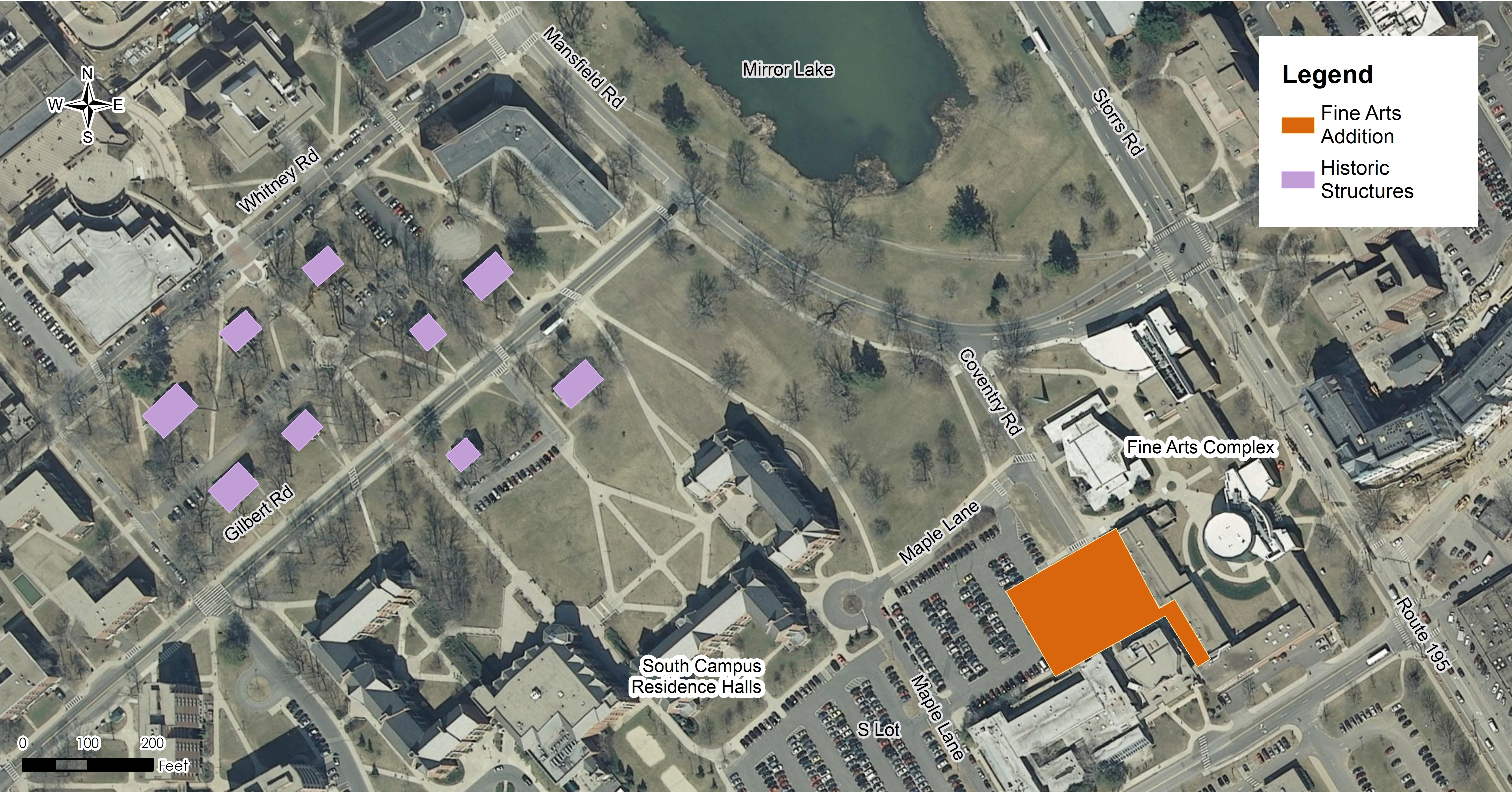
1. Notice of EIE for the University of Connecticut - South Campus Development
Municipality where project is proposed: Mansfield
Address of Possible Project Location: The area approximately bounded by Bolton Rd., Coventry Rd., Mansfield Rd., and Whitney Rd. on the University of Connecticut Storrs Campus, Mansfield, Connecticut.
Project Description: The University of Connecticut (UConn) has prepared an Environmental Impact Evaluation (EIE) pursuant to a Memorandum of Understanding, executed in August 2015, with Connecticut’s Office of Policy & Management and Department of Energy & Environmental Protection. UConn proposes to undertake the following projects in the area of the Storrs Campus known as the South Campus:
- Construction of an approximately 30,000 gsf addition to the Fine Arts building to add production space including paint, scene, costume, and prop shops. The addition will extend north from the Nafe Katter Theatre and west from the Drama-Music Building and will results in the removal of approximately 81 spaces from Lot 1.
-
Removal of nine houses along Gilbert Road and Whitney Road that are contributing structures to the University of Connecticut National Register Historic District.
The proposed Fine Arts addition will tie into campus-wide central utilities (electricity, water, sanitary sewer, natural gas, stormwater, and telecommunications) and building construction will incorporate best practices of sustainability with a minimum goal of Leadership in Energy & Environmental Design (LEED) Silver. UConn has coordinated with the Connecticut State Historic Preservation Office to finalize a formal agreement identifying mitigation measures for the removal of the cottages within the National Register Historic District.
UConn has prepared the EIE to further evaluate the potential environmental impacts of the Proposed Action, as well as other alternatives, including the No Action alternative. In addition to addressing potential impacts associated with the South Campus Development, secondary and cumulative impacts resulting from projects constructed in 2013-2015, as well as projects that will foreseeably be constructed during 2016-2018 are addressed in the SCD CEPA EIE.
Project Map:Click here to view a map of the area of the South Campus Development.
Comments on this EIE will be accepted until the close of business on: March 4, 2016
The public can view a copy of this EIE at:
1. Mansfield Town Clerk’s Office, Audrey P Beck Municipal Building, 4 South Eagleville Road, Mansfield, CT
2. Mansfield Public Library, 54 Warrenville Road, Mansfield, CT
There is a public hearing scheduled for this EIE on:
DATE: February 9, 2016
TIME: 7 p.m. (Doors will be open at 6:30 p.m. to allow review of informational materials.)
PLACE: Room 146, UConn Bishop Center; One Bishop Circle; Storrs, CT
NOTES:
Additional information about this project can be found online at:
http://www.envpolicy.uconn.edu/eie.html
Send your comments about this EIE to:
| Name: | Paul Ferri |
| Agency: | University of Connecticut – Office of Environmental Policy |
| Address: |
31 LeDoyt Road, U-3055, Storrs, Connecticut 06269
Phone: 860-486-9295
Fax: 860-486-5477
|
| E-Mail: |
If you have questions about the public hearing, or other questions about the EIE, contact Mr. Ferri as directed above.
2. Notice of EIE for Mansfield Four Corners Sewer Extension
Municipality where proposed project would be located: Mansfield
Project Location: Along Route 195 (Storrs Road), approximately 3,000 feet north and 1,000 feet south from its intersection with Route 44 (Middle Turnpike Road); along Route 44, approximately 600 feet east and 3,700 feet west from its intersection with Route 195; and along portions of North Hillside Road and Professional Park Road.
Project Description: Public Act 14-98, Section 97 authorized a $3 million grant-in-aid to the Town of Mansfield to extend sewers to the Four Corners area. The project involves installation of approximately 22,000 feet of sewer piping inclusive of collection system, a trunk sewer and a force main, two submersible pump stations, and related equipment and appurtenances to provide public sewer service to the Four Corners area as well as certain properties along Route 195 and Route 44, including a manufactured home development known as Rolling Hills Community. This area has a history of sewage disposal challenges due to high water table and poor soils. Wastewater would be discharged to the University of Connecticut’s wastewater treatment plant.
The Four Corners area is one of three main commercial centers in Mansfield. It serves as the northern gateway to Mansfield and has the benefit of being located at the crossroads of two state arterial roads. Plans to extend water and sewer to this area will enable redevelopment with a mixture of residential and commercial uses. Given its proximity to the new Technology Park, it is anticipated that this area will be focal point for research and light industry and may also become a priority housing location for Tech Park workers. The size of the area combined with extensive wetland resources will result in clusters of development that have been designated by the Town as appropriate for higher intensity uses.
Project Maps: Click here to view a map of the proposed sewer line.
Click here to view a map of the sewer service area.
The EIE and additional information about the project can be viewed in person at:
Department of Energy and Environmental Protection
Bureau of Water Protection & Land Reuse (2nd floor)
79 Elm Street
Hartford, CT 06106
The public can view a copy of this EIE at:
Mansfield Town Clerk's Office
Mansfield Town Hall
4 South Eagleville Road (Route 275)
Storrs, CT 06268
The EIE can also be found online at the DEEP website by clicking here.
There will be a Public Hearing for this project at:
DATE: March 8, 2016
TIME: 7:00 p.m.
PLACE: Council Chamber, Mansfield Town Hall; Four South Eagleville Road; Storrs, CT
Written comments from the public are welcomed and will be accepted until the close of business on: March 18, 2016
Written comments should be sent to:
| Name: | Carlos Esguerra |
| Agency: |
Department of Energy & Environmental Protection
Bureau of Water Protection & Land Reuse |
| Address: |
79 Elm Street
Hartford, CT 06106-5127
|
| Phone: | 860-424-3756 |
| Fax: | 860-424-4067 |
| E-Mail: | carlos.esguerra@ct.gov |
If you have questions about the public hearing, where you can review this EIE, or other questions about this project, contact Mr. Esguerra, as directed above.
The Connecticut Department of Energy and Environmental Protection is an Affirmative Action/Equal Opportunity Employer that is committed to complying with the requirements of the Americans with Disabilities Act. Any person with a disability who may need a communication aid or service may contact the agency's ADA Coordinator at 860-424-3194 or at deep.hrmed@ct.gov. Any person with limited proficiency in English, who may need information in another language, may contact the agency's Title VI Coordinator at 860-424-3035 or at deep.aaoffice@ct.gov. ADA or Title VI discrimination complaints may be filed with DEEP’s EEO Manager at (860) 424-3035 or at deep.aaoffice@ct.gov.
No State Land Transfer Notice has been submitted for publication in this edition.