

December 8, 2015
- Extended Comments Period! City of Waterbury Water Pollution Control Facility Comprehensive Facility Evaluation, Waterbury
- New Deadline for Public Comments! Various Bridge Rehabilitations / Route 8 North Bound Temporary Bypass, Waterbury
- New Parking Garage at Union Station, New Haven
- Intersection Improvements on Route 74 and Route 195, Tolland
- NEW! Parking Improvements for Pratt & Whitney Stadium at Rentschler Field, East Hartford
- NEW! Water and Sewer Line Extension and Housing Project, Stafford
- Revised Comments Deadline! Old Lyme Coastal Wastewater Management Plan, Old Lyme
- Eight Summit St. Stonington
"Scoping" is for projects in the earliest stages of planning. At the scoping stage, detailed information on a project's design, alternatives, and environmental impacts does not yet exist. Sponsoring agencies are asking for comments from other agencies and from the public as to the scope of alternatives and environmental impacts that should be considered for further study. Send your comments to the contact person listed for the project by the date indicated.
1. Notice of Scoping for City of Waterbury
Water Pollution Control Comprehensive Facility Evaluation
Municipality where proposed project would be located: Waterbury
Project Location: 210 Municipal Road, Waterbury, CT 06708
Project Description: The City of Waterbury Water Pollution Control Department is undertaking a comprehensive analysis of current operations at the Waterbury Water Pollution Control Facility (WPCF) to determine an overall roadmap for a long term plan for improvements. Issues to be addressed include operational upgrades required to meet new NPDES permit limits on phosphorous and metals, long term wet weather capacity, new Title V permits that would require capital improvements to the sludge incinerator, limitations on landfilling ash at the current location, and a desire to have a more sustainable operation with improved energy efficiency and potentially on-site energy generation. The plan will also address public concerns associated with the operation of a merchant incinerator in the most economically, socially and environmentally sound manner.
Project Maps: Click here to view a project location map.
Click here to view a project site plan.
A Draft Comprehensive Engineering Report for Phosphorus Removal is available.
It can be reviewed by clicking here.
Additional information about the project can be viewed in person at:
Department of Energy and Environmental Protection
Bureau of Water Protection & Land Reuse (2nd floor)
79 Elm Street
Hartford, CT 06106
The comment period has been extended.
Written comments from the public are welcomed and will be accepted until the close of business on: December 22, 2015
Written comments should be sent to:
| Name: | Ann Straut |
| Agency: |
Department of Energy & Environmental Protection
Bureau of Water Protection & Land Reuse |
| Address: |
79 Elm Street
Hartford, CT 06106-5127
|
| Phone: | 860-424-3137 |
| Fax: | 860-424-4067 |
| E-Mail: | ann.straut@ct.gov |
If you have questions about scoping for this project, contact Ms. Straut, as directed above.
The Connecticut Department of Energy and Environmental Protection is an Affirmative Action/Equal Opportunity Employer that is committed to complying with the requirements of the Americans with Disabilities Act. Any person with a disability who may need a communication aid or service may contact the agency's ADA Coordinator at 860-424-3194 or at deep.hrmed@ct.gov. Any person with limited proficiency in English, who may need information in another language, may contact the agency's Title VI Coordinator at 860-424-3035 or at deep.aaoffice@ct.gov. ADA or Title VI discrimination complaints may be filed with DEEP’s EEO Manager at (860) 424-3035 or at deep.aaoffice@ct.gov.
2. Notice of Scoping for Various Bridge Rehabilitation at Route 8/ I-84 "Mixmaster" Interchange including Construction of Route 8 NB Temporary Bypass
Municipality where proposed project might be located: Waterbury
Address of Possible Project Location: Route 8 / Route I-84 Interchange
The proposed project consists of deck repair, steel repair, substructure repair, joint repair, parapet modifications and general repair to bridge drainage, and signage. Bridge No. 03190A, carrying Route 8 Northbound, will have the entire concrete deck replaced. Because of this, a temporary bypass will be utilized to relocate Route 8 Northbound while the concrete deck is being replaced. The proposed alignment for this Temporary Bypass, two lane urban expressway, is approximately 3/4 mile long with three (3) temporary bridges. The alignment from south to north will begin the Temporary Bypass on existing Route 8 Northbound just north of the Bank Street Overpass. The Temporary Bypass will end on existing Route 8 Northbound approximately 350 feet north of the Freight Street overpass. The Route 8 Northbound Exit 30 On Ramp, and the Route 8 Northbound Exit 32 Off Ramp will be closed during the deck replacement of Bridge No. 03191A, eliminating access from Route 8 Northbound to I-84. See map for proposed temporary bypass below.
In order to avoid conflicts with the Temporary Bypass and to maintain local traffic flow, Southbound Riverside Street will temporarily be converted to a bidirectional roadway with one lane in each direction between Sunnyside Avenue and Freight Street. This will temporarily relocate Northbound Riverside Street onto the eastern lane of Southbound Riverside Street. Northbound Riverside Street between Sunnyside Avenue and Freight Street will be utilized for the Temporary Bypass.
In order to mitigate for the loss of access from Route 8 Northbound to I-84 due to the exit closures listed above, a new single lane northbound and southbound will be constructed at and within the Exit 35 Right of Way. This will allow a Median U-turn to be constructed within the infield connecting the existing left lanes of the northbound and southbound roadways (Watertown Connector/Route 73). This will allow traffic that utilizes the Temporary Bypass to complete the connections to Interstate 84.
Written comments from the public are welcomed and will be accepted until the close of business on: December 31, 2015.
There will be a Public Scoping Meeting for this project at:
Additional information about the project can be viewed in person at or online at:
The Connecticut Department of Transportation, 2800 Berlin Turnpike, Room 3303, Newington, CT 06131
and
City of Waterbury Clerk's Office, 235 Grand Street, Waterbury, CT 06702
Written comments should be sent to:
| Name: |
Mr. Mark W. Alexander, Transportation Assistant Planning Director
|
| Agency: |
Connecticut Department of Transportation
|
| Bureau of Policy and Planning | |
|
Address:
|
2800 Berlin Turnpike
|
| Newington, CT 06131 | |
| Fax: | 860-594-3028 |
| E-Mail: |
If you have questions about the public meeting, or other questions about the scoping for this project, contact:
| Name: | Mr. Robert P. Brown, P.E., Project Manager |
| Agency: | Connecticut Department of Transportation |
| Bureau of Engineering and Construction | |
| Address: | 2800 Berlin Turnpike |
| Newington, CT 06131 | |
| Phone: | 860-594-3207 |
| E-Mail: | Robert.Brown@ct.gov |
Other information: The location is ADA accessible. If language assistance is needed, please contact the Department of Transportation's Office of Communications at (860) 594-3062 before November 11, 2015.
3. Notice of Scoping for New Parking Garage at Union Station
Municipality where proposed project might be located: New Haven
Address of Possible Project Location: Union Avenue, New Haven, CT 06519
Project Description: The Connecticut Department of Transportation (Department) is proposing to construct a new multi-level parking facility for Union Station in the City of New Haven. The project area is State of Connecticut property located north of the station and is currently being used as a commuter parking lot. The proposed parking facility will accommodate approximately 1000 parking spaces, thereby expanding commuter parking at the station to address existing and future parking needs. The facility will be designed with consideration to the historic significance, scale, and aesthetic quality of the station building, and will be limited to seven parking levels. The project also proposes new pedestrian accommodations through the existing garage to enhance access to the station from the proposed parking facility. Direct access to the rail platforms from the proposed facility via a future pedestrian bridge is also being considered in the planning and design stages of this project.
Project Map: Click here to view a map of the project area.
Written comments from the public are welcomed and will be accepted until the close of business on: Thursday December 31, 2015.
There will be a Public Scoping Meeting for this project at:
DATE: Tuesday, December 15, 2015 (inclement weather date of December 16, 2015)
TIME:6:30 - 8:00 p.m. for drop-in informational session. Brief presentation at 7:00 p.m.
PLACE: Union Station Balcony, Union Avenue, New Haven, CT 06519
NOTES: The meeting location is accessible to persons with disabilities. Deaf and hearing impaired persons wishing to attend this meeting and requiring an interpreter may make arrangements by contacting the Department's Office of Communications at 860-594-3062 (voice only) at least five days prior to the meeting.
Written comments should be sent to:
| Name: | Mr. Mark W. Alexander - Transportation Assistant Planning Director |
| Agency: | State of Connecticut Department of Transportation |
| Bureau of Policy and Planning | |
| Address: | 2800 Berlin Turnpike, Newington, CT 06131 |
| Fax: | 860-594-3028 |
| E-Mail: | dot.environmentalplanning@ct.gov |
If you have questions about the public meeting, or other questions about the scoping for this project, contact:
| Name: | Mr. Keith A. Hall - Transportation Supervising Engineer |
| Agency: | State of Connecticut Department of Transportation |
| Bureau of Engineering and Construction | |
| Address: | 2800 Berlin Turnpike, Newington, CT 06131 |
| Phone: | 860-594-3301 |
| Fax: | 860-594-3375 |
| E-Mail: | Keith.A.Hall@ct.gov |
The agency expects to release an Environmental Impact Evaluation for this project, for public review and comment in Spring 2016
4. Notice of Scoping for Intersection Improvements on Route 74 and Route 195 near the Tolland Green
Municipality where proposed project might be located: Tolland
Address of Possible Project Location: Route 74 between the intersections with Old Stafford Road and Route 195 (Merrow Road) near the historic Tolland Green.
Project Description: The purpose of this project is to address capacity concerns and vehicular and pedestrian safety concerns at the intersections listed above while creating gateway features on Route 74 and Route 195 to calm traffic prior to entering the Town Green area.
Route 195 will be widened approximately 300 feet south of Old Post Road to accommodate a splitter island to slow vehicles entering and leaving the Town Green area. It is also suggested that the existing gateway signage to the Historic Town Green be moved closer to the Southerly Gateway to improve the sign's effectiveness.
Extending north from the Southerly Gateway, the widening of Route 195 will accommodate an exclusive left-turn lane at Old Post Road. The receiving northbound lane will require realignment, which will have minor impacts to the southwest corner of the Town Green. The southerly leg of the intersection will be widened to allow for: two travel lanes, a left-turn lane, and two 4-foot shoulders. On the northern leg of the intersection, the existing southbound shoulder will be narrowed to shorten the distance of the crosswalk. Minor realignments to both legs of Old Post Road will be required due to the modification on Route 195 and new proposed signal.
The existing configuration of the intersections of Route 74 at Route 195 and at Old Stafford Road will be realigned. The easterly leg of Route 74 will be realigned to the south to form a new stop controlled "T" type intersection with Route 195. The approach to Route 74 from Old Stafford Road will be realigned to the west to form a "T" type intersection. Both intersections will be side-street, stop-sign controlled. The mid-block crosswalk, currently south of the existing Route 74/195 intersection, will be relocated north to the intersection. A raised island will also be installed south of the new Route 74/195 intersection to provide additional traffic calming.
Roadway widening and realignment will be utilized westward from the intersection of Route 74 and Old Stafford Road to provide traffic calming. In order to avoid impacting historic homes in the area, the new horizontal curvature and widening will be such as to realign the roadway away from the historic properties. Drainage modifications will be required as a result of the widening and realignment. Full-depth reconstruction of the pavement structure is proposed for the entire project.
Project Map: Click here to view a map of the project area.
Click here to view proposed project conceptual plans.
Written comments from the public are welcomed and will be accepted until the close of business on: Friday December 24, 2015 (If the scheduled meeting is postponed to December 15, 2015, comments will be accepted until the close of business on December 31, 2015).
There will be a Public Scoping Meeting for this project at:
DATE: Thursday, December 10, 2015 (inclement weather date Tuesday December 15, 2015)
TIME: 7:00 P.M.
PLACE: Hicks Memorial Municipal Center, Conference Room A
21 Tolland Green, Tolland, CT
NOTES: Plans will be available at the Hicks Memorial Municipal Center two weeks prior to the meeting.
Written comments should be sent to:
| Name: | Mr. Mark W. Alexander, Transportation Assistant Planning Director |
| Agency: | Connecticut Department of Transportation |
| Bureau of Policy & Planning | |
| Address: | 2800 Berlin Turnpike |
| Newington, CT 06131 | |
| Fax: | 860-594-3028 |
| E-Mail: | dot.environmentalplanning@ct.gov |
If you have questions about the public meeting, or other questions about the scoping for this project, contact:
| Name: | Mr. Joseph D. Arsenault |
| Agency: | Connecticut Department of Transportation |
| Bureau of Engineering and Construction | |
| Address: | P.O. Box 317546 |
| Newington, CT 06131 | |
| Phone: | 860-594-3471 |
| E-Mail: |
Other information: The meeting facility is ADA accessible. If language assistance is needed, please contact the Department of Transportation's Office of Communications (voice only) at 860-594-3062 at least 5 business days prior to the meeting.
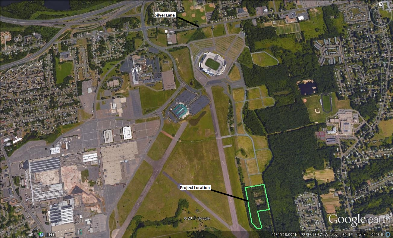
5. Notice of Scoping for Parking Improvements for Pratt & Whitney Stadium at Rentschler Field
Municipality where proposed project might be located: East Hartford
Address of Possible Project Location: 615 Silver Lane
Project Description: The Office of Policy and Management and the Capital Region Development Authority are proposing to develop grass parking lots and internal gravel roadways on a 10-acre parcel that was recently contributed to the State of Connecticut by United Technologies Corporation. The site previously housed operations of Pratt & Whitney Aircraft Company (P&W), and roadways, parking areas and foundations from those operations remain in place. Some portions are fully wooded with the balance being successional tree and shrub growth. The parcel adjoins existing stadium grass parking lots that were developed in 2011 on other former P&W land. Work will consist of clearing and grubbing of most existing vegetation, demolition of pavement and structure remains, regrading to achieve proper drainage, replacement of exiting roadways with gravel drive lanes and seeding with a durable, drought-tolerant grass mix suitable for parking use. A short segment of piped stormwater drainage may be needed, as well. The work will be contracted by the Capital Region Development Authority, which operates Pratt & Whitney Stadium on behalf of OPM. The property will be used for patron parking for major events at the stadium, and may be used occasionally for other events, such as charity walks.
Most of the parcel was included in the areas studied for proposed stadium parking in the 2006 “Environmental Impact Evaluation for Proposed Infrastructure Improvement and Rentschler Field Development” prepared by the Department of Economic and Community Development, with OPM as a participating agency. The final boundaries of the contributed parcel include an area of slightly more than 2 acres that lies outside the limits of the prior study of parking lands. However, this acreage was studied in the EIE as part of the proposed area of later phase development of Rentschler Field. OPM is now seeking comments on potential impacts of this development as part of a slightly differing contemplated State action.
Project Maps: Click here to view a map of the project area.
Click here to view the Record of Decision for the 2006 EIE.
Written comments from the public are welcomed and will be accepted until the close of business on: January 8, 2016
Any person can ask the sponsoring agency to hold a Public Scoping Meeting by sending such a request to the address below. If a meeting is requested by 25 or more individuals, or by an association that represents 25 or more members, the sponsoring agency shall schedule a Public Scoping Meeting. Such requests must be made by December 18, 2015.
Written comments, questions about this scoping notice, and/or requests for a Public Scoping Meeting should be sent to:
| Name: | Phil McLellan |
| Agency: | Office of Policy and Management |
| Address: |
Adriaen's Landing/Rentschler Field Project Office
100 Columbus Boulevard, Suite 501
Hartford, CT 06103
|
| Phone; | 860-493-2928 |
| E-Mail: | phil.mclellan@ct.gov |
|
OPM is fully committed to complying with the Americans with Disabilities Act. Any person with a disability who may need a communication aid or service in conjunction with this notice may contact OPM as indicated above. Any person with limited proficiency in English, who may need information in another language, may also contact OPM as indicated above. |
1. Post-Scoping Notice for Water and Sewer Line Extension and Housing Project
Municipality where project will be located: Stafford
CEPA Determination: On September 8, 2015 the Depatment of Housing published a Notice of Scoping to solicit public comments for this project in the Environmental Monitor. The Depatment of Housing has taken those comments into consideration and has concluded that the project does not require the preparation of Environmental Impact Evaluation under CEPA.
The agency's conclusion is documented in a Memo of Findings and Determination and an Environmental Assessment Checklist.
If you have questions about the project, you can contact the agency at:
|
Name: |
Dimple Desai |
|
Agency: |
Department of Housing |
|
Address: |
505 Hudson Street, Hartford, CT 06106 |
|
Phone: |
(860) 270-8012 |
|
Fax: |
(860) 706-5741 |
|
E-Mail: |
Dimple.Desai@ct.gov |
What happens next: The Depatment of Housing expects the project to go forward. This is expected to be the final notice of the project to be published in the Environmental Monitor.
1. Environmental Impact Evaluation for Old Lyme Coastal Wastewater Management Plan
Municipality where proposed project would be located: Old Lyme
Addresses of Possible Project Locations: Shoreline communities located south of and along Route 156 between Miami Beach Association and Old Lyme Shores Beach Association, and the Route 156 corridor to East Lyme
Project Description: The Beach Associations of Old Lyme Shores, Old Colony Beach and Miami Beach have conducted independent engineering studies showing that the prevalent conditions in the project area such as the age and location of existing onsite wastewater treatment systems, high density of development, lack of adequate space and overall challenging subsurface conditions, such as shallow groundwater, have rendered the onsite wastewater treatment systems economically and technically unfeasible for long term wastewater renovation.
A centralized gravity sewer system to be constructed by the three Beach Associations has been identified the most cost effective and technically feasible solution. Wastewater from the associations would be collected via gravity pipes and conveyed through one shared pump station and force main. It is currently envisioned that the centralized pump station would be located within Miami Beach Association. Wastewater from Old Colony Beach Association would be transported to the Miami Beach Association through an easement located within Sound View. The pipe traversing across Sound View would enable this community to tie-in, should Old Lyme join the Associations in the future. Wastewater would be conveyed along Route 156 to East Lyme and then through the existing collection systems of East Lyme and Waterford for final treatment at the New London Water Pollution Control Facility.
Project Maps: Click here to view the areas to be sewered.
Click here to view the proposed sewer system.
Click here to view the proposed conveyance system.
The EIE and additional information about the project can be viewed in person at:
Department of Energy and Environmental Protection
Bureau of Water Protection & Land Reuse (2nd floor)
79 Elm Street
Hartford, CT 06106
The public can view a copy of this EIE at:
Old Lyme Town Clerk
Old Lyme Memorial Town Hall
52 Lyme Street
Old Lyme, CT 06360
The EIE can also be found online at the DEEP website by clicking here.
The request for public hearing from the Sound View Beach Association in Old Lyme has been withdrawn. Accordingly, a public hearing will not be held. The deadline for comments has been extended until the close of business on December 16, 2015.
Written comments about this EIE should be sent to:
| Name: | Carlos Esguerra |
| Agency: | Department of Energy & Environmental Protection |
| Bureau of Water Protection & Land Reuse | |
| Address: | 79 Elm Street |
| Hartford, CT 06106-5127 | |
| Phone: | 860-424-3756 |
| Fax: | 860-424-4067 |
| E-Mail: | carlos.esguerra@ct.gov |
The Connecticut Department of Energy and Environmental Protection is an Affirmative Action/Equal Opportunity Employer that is committed to complying with the requirements of the Americans with Disabilities Act. Any person with a disability who may need a communication aid or service may contact the agency's ADA Coordinator at 860-424-3194 or at deep.hrmed@ct.gov. Any person with limited proficiency in English, who may need information in another language, may contact the agency's Title VI Coordinator at 860-424-3035 or at deep.aaoffice@ct.gov. ADA or Title VI discrimination complaints may be filed with DEEP’s EEO Manager at (860) 424-3035 or at deep.aaoffice@ct.gov.
The following State Land Transfer Notice has been submitted for publication in this edition.
1. Notice of Proposed Land Transfer, Stonington
Complete Address of Property: 8 Summit Street, Stonington
Commonly used name of property or other identifying information: N/A
Number of acres to be transferred: 4.4
Click to view map of property location
Description of Property
Below is some general information about the property. It should not be considered a complete description of the property and should not be relied upon for making decisions. If only a portion of a property is proposed for transfer, the description pertains only to the portion being transferred.
Brief Description of Historical and Current Uses: Vacant building and parcel. No known past use.
The property to be transferred contains the following:
| Structures: | Buildings in use | x | Buildings not in use | No Structures | ||
| Other Features: | x | Wooded land | Nonagricultural fields | Active agriculture | ||
| x | Paved areas | Ponds, streams, other water, wetlands | ||||
| Water Supply: | x | Public water supply | On-site well | Unknown | ||
| Waste Disposal: | Served by sewers | On-site septic system | x | Unknown | ||
Click to view aerial view of property
The property is in the following municipal zone(s):
| x | Residential | Industrial | Commercial | Institutional | |||
| Other: | |||||||
| Not zoned | Not known | ||||||
Special features of the property, if known: Unknown
Value of property, if known:
| x | If checked, value is not known. |
Type of Sale or Transfer:
| x | Sale or transfer of property in fee |
| Sale or transfer of partial interest in the property (such as an easement). Description of interest: |
Proposed recipient, if known: Unknown
Proposed use by property recipient, if known: Unknown
The agency is proposing to transfer the property with the following restrictions on future uses:
| x | If checked, the state is not currently proposing restrictions on future uses. |
Reason the State of Connecticut is proposing to transfer this property: The subject property is no longer needed by the state.
Comments from the public are welcome and will be accepted until the close of business on December 17, 2015.
Comments may include (but are not limited to) information you might have about significant natural resources or recreation resources on the property, as well as your recommendations for means to preserve such resources.
Written comments* should be sent to:
|
Name: |
Patrick O'Brien |
|
Agency: |
Office of Policy and Management |
Address: |
450 Capitol Avenue MS#52 ASP |
| Hartford, CT 06106-1379 | |
|
E-Mail: |
Patrick.Obrien@ct.gov |
*E-Mail submissions are preferred.
Please send a copy of comments to:
Shane Mallory, DAS
165 Capitol Ave, G-1
Hartford, CT 06106
shane.mallory@ct.gov
(Comments from state agencies must be on agency letterhead and signed by agency head. Scanned copies are preferred.)
To find out if this proposed transfer is the subject of further notices, check future editions of the Environmental Monitor.Sign up for e-alerts to receive a reminder e-mail on Environmental Monitor publication dates.