
The Hydrologic Cycle
The Hydrologic Cycle
When considering where all the water we use comes from, here’s another quick fact to remember: all the water there is, is all the water there is. Expressed slightly more scientifically, the total quantity of water on our planet is a constant sum that moves freely over and under the earth. It is true that the water you drink this afternoon is the same water ancient Egyptians used to irrigate their fields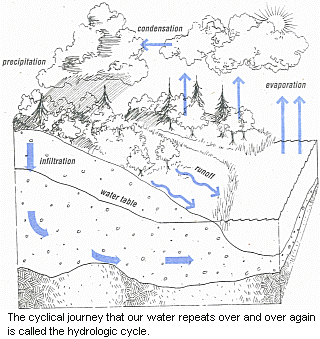 , the same water Columbus crossed to discover the New World.
The water on what astronauts call this “blue planet” can exist as a gas (water vapor), a liquid (oceans, rivers, groundwater), and a solid (ice, snow). Its ceaseless movement is called the hydrologic cycle, a sort of conveyor belt that is perpetually transforming and transporting the earth’s age-old/brand-new water.
Powered by the sun, the hydrologic cycle begins when water, evaporated from oceans, lakes, rivers and land, or transpired by plants, rises into the atmosphere. Once aloft, this water vapor is pushed over the earth by winds. When the water vapor cools, clouds form. When cooled more, it condenses into droplets that fall to earth as precipitation, as rain, snow, sleet or hail.
Precipitation takes one of two paths once on the ground. It runs over the surface into rivers, lakes or the ocean, and becomes surface water, or it soaks into the earth and becomes groundwater.
When water enters soil-infiltration-gravity pulls it down through the unsaturated zone where spaces between soil particles are empty and water can readily pass through.
Eventually, the water reaches the saturated zone where it fills all open spaces. The water table is the surface between the unsaturated and saturated zones, the level bel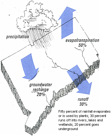 ow which spaces are filled with water.
A water table is dynamic. It falls and rises in rhythm with ever-changing natural conditions and human demand. It swells after a heavy rain; falls in droughts. It rises in fall and winter, when plants are dormant, evaporation is low, and human demand decreases. It falls in spring and summer when plant life lushly grows, the strong sun quickly sponges up water vapor and human consumption peaks.
In this climate, the precipitation needed to replenish or recharge Connecticut water tables averages three to four inches per month. About one quarter of all precipitation that falls in this state becomes groundwater.
Generally, surface and groundwater flows in Connecticut are predictable and their patterns can be organized into natural hydrologic land units called drainage basins or watersheds.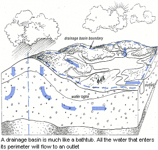
A drainage basin might be viewed as a very large bathtub, whose rim is the perimeter of the tallest land surrounding a stream or lake, whose drain, the lowest point, is the watershed outlet. The water in a drainage basin arrives as rain or snow, and exits as water vapor (transpired by plants or evaporated from the land) or as surface runoff through the drain.
Just as surface water within a basin moves through streams, rivers, wetlands or lakes to reach the basin outlet, so does groundwater flow within a basin. Pulled by gravity, groundwater moves from hills into valleys and discharges directly into wetlands, rivers and lakes. A spring may appear where a water table intercepts a ground surface. During a dry spell, a stream’s flow will be sustained by groundwater.
One major difference between surface water and groundwater is the speed at which each flows. The flow rate of surface water is measured in feet-per-second; groundwater usually moves only a few feet per day. With such a slow flow rate, groundwater can remain within a particular watershed for many years before it eventually exits.