
Aquifers
Aquifers
 You probably know that an aquifer has something to do with water supplies. Its more scientific definition is any geologic formation that allows for the withdrawal of usable amounts of water. Although geologic conditions vary across Connecticut, there’s usually enough groundwater available anywhere to supply the water needs of at least one single family residence and, for this reason, our whole state might be considered an aquifer.
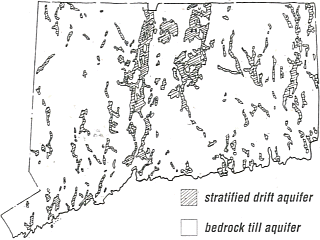
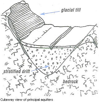 Connecticut is mainly comprised of two types of aquifers. Bedrock-till formations underlie the entire state. Stratified drift formations lie in river valleys.
Bedrock-till aquifers are made up of different rock types and are covered by till, a residual glacial mix of rocks, sand, silt and clay. Most till in Connecticut is about fifteen feet thick. A bedrock-till aquifer can yield as much as ten gallons of water per minute, or enough water for a small business or single family home. The major water transport in bedrock-till aquifers occurs in the fractures and faults of the underlying bedrock.
A stratified drift aquifer is comprised of layered deposits of sand, gravel, silt and clay laid down thousands of years ago by glacial meltwaters. Water yields of millions of gallons per day are possible wherever deep saturated deposits of porous sand and gravel are found. Some sections of Connecticut that have these high-yield conditions have been developed as municipal water supplies. Because stratified drift aquifers exist mainly in major river valleys-the same places we find most of our cities and large industries unfortunately they can easily become contaminated.