
Land Stewardship
Preserved Land Farmland Wetlands
Forests
Forest Inventory*: It is estimated that forests cover about 58 percent of the land area in the state. The amount of forest land in Connecticut in 2024 (most recent data available) is estimated to have decreased since the 2023 inventory and was 0.4 percent less than the previous ten-year average. Approximately 71 percent of forest land in Connecticut is privately owned.13 In 1972, the first full year of the Council’s existence, the amount of forest land in Connecticut was estimated to be 1,860,800 acres or about 59 percent of the area of the state14
<
Forests and other natural habitats reduce adverse water quality impacts associated with development, impervious surfaces, and certain agricultural practices; sequester and store carbon; and provide valuable habitat. Research shows that visiting a forest has quantifiable physical and mental health benefits.15
 Core Forest Acres**: Core forests are defined as unfragmented forest land that is 300 feet or greater from the boundary between forest land and non-forest land. Core forests provide habitat for many species of wildlife (edge-intolerant species), provide connectivity and corridors for species migration, and increase overall biodiversity. The loss of core forests diminishes the remaining forests’ water purification and habitat values, and could result in heavier runoff, which might lead to poorer water quality and increased flooding. Forests that are fragmented, or divided by roads and development, provide some forest functions, but do not contribute the full range of ecosystem services that larger core forest blocks do. recreational activities. Invasive species often colonize areas in the wake of activities that result in fragmented forests, thereby diminishing further the value of such forests
As depicted in the chart above, large (>500 acres) core forests, which make up approximately 35 percent of the total core forest area in Connecticut, have seen the greatest percentage decline since 1985 (-17.5 percent). Patch forests (19.2 percent) and perforated forests (14.8 percent) have seen the greatest percentage increase over that same time period; however, patch forest and perforated forests only make up 3.8 percent and 10.7 percent of forest type in Connecticut, respectively. Overall, total core forest area has declined by more than 12 percent over the last 38 years.18
Connecticut’s forests sequester and store carbon above and below ground in their roots, trunks and branches and as long-lived wood products (e.g., carbon stored in lumber and furniture). Carbon sequestration rates and storage vary by stand age, tree species, growing conditions (including soil type, regional climate, topography), and disturbance regimes (natural or silvicultural).19 In the northeastern United States, carbon sequestration rates typically peak when forests are around 30–70 years old, but trees continue to sequester carbon through their entire life span.
Urban forests are composed of all trees within urban areas. Urban forests differ from rural forests in that urban forests typically have a lower density and percentage of tree cover, and the trees are often associated with human activity and built structures. In 2020, approximately 35 percent of Connecticut’s land area was designated as “urban”.21 Connecticut also had one of the highest urban tree cover in the nation at 61.6 percent (2014).22 Urban trees and forests help keep cities cooler and absorb stormwater; help filter the air and water; maintain biodiversity; and increase resilience to climate change impacts.23
In 2025, $1.17 million in grants were awarded from DEEP’s urban and community forestry grant programs, including the Trees for Communities Grant, Urban Forested Natural Areas and Riparian Corridor Restoration Grant Program, and Urban and Community Forestry Planning Grant Program. In addition, the Connecticut Urban Forest Council administered over $450,000 in Urban Forestry Climate Change Grants with pass-through funding from DEEP’s Urban and Community Forestry Program, through the Regional Greenhouse Gas Initiative.24
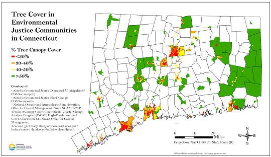
Goal: “Keeping forest as forest” is the overarching goal of Connecticut’s 2020 Forest Action Plan. Public Act 23-206, Section 2 established a goal for environmental justice communities with current tree canopy cover less than 40 percent to increase the tree canopy area by five percent by 2040.
Technical Note: *The vertical axis in the “Forest Inventory” chart above has been shortened, beginning at 1,000 (1,000 acres) or one million acres rather than the customary zero. There is no data for estimated forest acres for 2022. **Estimates of core forest acres were derived from data of the University of Connecticut’s (UConn) Center for Land Use Education and Research (CLEAR), which uses imagery and data derived from the National Land Cover Database (NLCD)- 30-meter resolution, to identify forests that are at least 300 feet from non-forest development, such as roads, buildings and farms.
_________
13United States Department of Agriculture (USDA) Forest Service. Forests of Connecticut, 2024. Resource Update FS-571. October 2025; public.tableau.com/views/FIA_OneClick_V2/Pagetwo?%3Aorigin=viz_share_link&%3AshowVizHome=no#2.
14 DEEP and the United States Department of Agriculture Forest Service, Trends In Connecticut’s Forests: A Half-Century of Change, NE-INF-143-01; www.fs.usda.gov/ne/newtown_square/publications/brochures/pdfs/state_forests/ct_forest.pdf.
15 New York Department of Environmental Conservation, Immerse Yourself in a Forest for Better Health; www.dec.ny.gov/lands/90720.html#:~:text=We%20enjoy%20the%20beauty%20and,green%20spaces%20may%20improve%20health.
16DEEP, GC3 Final Report: Working & Natural Lands Working Group - Rivers Sub-Working Group, p. 5; portal.ct.gov/-/media/DEEP/climatechange/GC3/GC3-working-group-reports/GC3-WNLWG-Rivers-Final-Report-11-20-20.pdf.
17 University of Connecticut (UConn), Center for Land Use Education and Research (CLEAR), CT Forest Fragmentation; clear.uconn.edu/projects/landscape/ct-forestfrag/.
18 UConn, CLEAR, personal communication from Q. Lei-Parent received February 23, 2025.
19 DEEP, 2020 Connect Forest Action Plan; portal.ct.gov/-/media/DEEP/forestry/2020-Approved-CT-Forest-Action-Plan.pdf.
20 DEEP, D. Danica and UConn, I. Zafetti, personal communication 3-12-2024.
21 United State Census Bureau, County-level Urban and Rural information for the 2020 Census, (Updated September 2023) County-level 2020 Census Urban and Rural Information for the U.S., Puerto Rico, and Island Areas sorted by state and county FIPS codes, accessed March 18, 2024; www2.census.gov/geo/docs/reference/ua/2020_UA_COUNTY.xlsx.
22Nowak, David J; Greenfield, Eric J. 2018. US Urban Forest Statistics, Values, and Projections. Journal of Forestry. 116(2): 164-177.; www.fs.usda.gov/nrs/pubs/jrnl/2018/nrs_2018_Nowak_003.pdf.
23 DEEP, General Urban Forestry Information; portal.ct.gov/DEEP/Forestry/Urban-Forestry/General-Urban-Forestry-Information.
24 DEEP, Urban and Community Forestry Grant Accomplishments, 2025; portal.ct.gov/DEEP/Forestry/Urban-Forestry/General-Urban-Forestry-Information.