

Rivers + Reservoirs
Rivers, Streams & Rain Bald Eagles Drinking Water

Rivers and Streams
and Rainfall Trouble

Throughout the state, about 30 percent of assessed river miles are classified as being clean enough for swimming and other water contact sports.
More than 1,300 miles were assessed by DEEP as to their safety for swimming and other recreation. About 397 miles (30 percent) are clean enough to fully support contact recreation. Read more about recreation in Connecticut's streams...
____________
The ecological health of a stream depends very much on a single factor: the percentage of the land in its watershed that is paved.
In nearly all cases, a stream that has less than 
12 percent of its watershed covered
by impervious surfaces will fully support
aquatic life (shown as blue). Impervious
surfaces are largely pavement and rooftops.
If watershed is less than 12% paved
In all cases, streams where more than 12 
percent of the watershed is impervious will
not fully support aquatic life (shown as gray).
If watershed is more than 12% paved
The watershed of a stream is all of the land from which water flows to the stream. For illustration, think of a stream as the drain of a bathtub; the watershed is the entire bathtub.
A survey of 99 stream segments conducted by DEEP found that aquatic life is measurably affected when impervious surfaces -- largely pavement and rooftops -- cover 12 percent or more of the stream's watershed. (See pages 35 and 36 of linked document.) No stream fully supported aquatic life where this 12-percent threshold was exceeded. Read more about aquatic life...
________
Rain: Too Little and Too Much
or, It Never Rains But it Pours
Dry streambeds were a common sight in 2016 as most of Connecticut experienced extreme or severe drought.
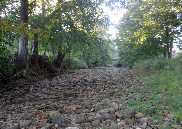
Weekeepeemee River (in Woodbury), 2015
(Photo courtesy of the Pomperaug River Watershed Coalition)
At the same time, Connecticut faces increasing probabilities of intense rains that cause flooding and pollution. At the Connecticut Department of Emergency Services and Public Protection's Division of State Police firearms training facility in Simsbury, for example, floodwaters have reached or exceeded the level shown below at least five times in the last ten years.
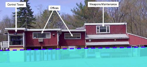
(Photograph courtesy of the Dep't of Administrative Services Construction Services)
Most of the pollution problems observed in small streams, discussed above, can be traced to excessive runoff from land, especially land covered by impervious surfaces such as pavement. Additional information on the growing frequency of heavy rains can be found on the Swimming, Clamming, and Heavy Rain page of this Report.
One solution to both rainfall problems -- dry streams and floods -- is to reduce the area of impervious surfaces. Such reductions allow more rain to reach the groundwater table to keep wells and stream flowing during dry weather.
More about recreation in Connecticut's streams
In most sections of rivers and streams, bacteria levels are higher, at least some of the time, than what is considered safe for a person swimming or playing in the water. Detailed information is contained in the 2016 Integrated Water Quality Report released by DEEP in early 2017. The 2014 edition also estimated the percent of suitable streams to be 30%. The 2011 edition of that report estimated the percentage of fully safe rivers to be about 11, while the 2008 edition of that report estimated the percentage to be 15.
A separate statistical analysis performed by DEEP in 2010 estimated that 47 percent of wadeable streams (which are streams shallow enough to be sampled using methods that involve wading) are suitable for recreation that involves contact with the water. (See page 42 of linked document.)
Apparent fluctuations in year-to-year results are probably due to limitations in data collection and study design and not to widespread changes in water quality. There are estimated to be 5,830 river miles in Connecticut. Not all are sampled with the same frequency. Sampled locations retain their designation until re-sampled, at irregular intervals. The inescapable conclusion of all the analyses is that the water in most Connecticut streams and rivers might not always be safe for swimming and similar activities.
Numerous analyses point to the importance of keeping impervious surfaces to a minimum and reducing the runoff that flows directly from pavement into waterways. The University of Connecticut's NEMO (Nonpoint Education for Municipal Officials) program maintains an atlas of projects and an inventory of municipal regulations designed to reduce the impacts of impervious surfaces. About one in five municipalities have adopted regulations that protect vegetation along streams; such regulations can yield significant beneficial results for streams and rivers, but nearly all of those towns limit the protection to a small number of named streams.
There are hundreds of small streams where the water is very clean, and many of these have been documented by volunteers working with DEEP's Riffle Bioassessment by Volunteers (RBV) program. In 2017-2018, RBV enlisted more than 400 students and adults to sample the aquatic life from 97 unique locations on 81 different waterbodies. Sixty-six (66) of the monitoring sites had four or more types in the ‘Most Wanted’ taxa type, indicating that these stream segments had excellent water quality.
____________
About 80 miles of rivers are polluted by overflows of raw sewage.
In 15 Connecticut cities and towns, sanitary sewers were built in combination with storm sewers. When it rains, these combined systems carry more water than their treatment facilities can handle, and a combination of stormwater and untreated sewage overflows directly into the rivers and Long Island Sound. Regrettably, scientists predict climate change to yield more frequent high-intensity rainfall events in Connecticut. During very heavy rains, the sewage treatment systems of many other municipalities, even those without combined sanitary and storm sewers, are overwhelmed and spill untreated or poorly-treated sewage to rivers and harbors.
Several of the combined sewer systems have been completely or partly separated since 1990, reducing the volume of untreated sewage in rivers. Four cities that still contain multiple combined-sewer overflows -- Bridgeport, Hartford, New Haven and Norwich -- have reduced the number of overflow points, but about a hundred remain. Two other cities, Norwalk and Waterbury, have reduced their overflows to periods of exceptionally wet weather. New Haven is working on several projects that result in storing sewage within the sewer pipes so that the discharge points release less untreated sewage. New Haven estimates a 12.9 million gallon reduction in discharge from the amount in 2014 to what was released in 2016.
DEEP maintains an interactive map showing the exact locations where sewage is known to overflow into waterways. The law that led to the map also required DEEP to publish notices of actual overflow events starting in 2014, but that deadline was not met.
Connecticut's goal is to eliminate the effects of raw sewage discharges from combined sewer systems. Progress is slow because of the extraordinary expense of separating the sewers.
*Links to flow data for many Connecticut streams, as monitored and reported by the U.S Geological Survey, and other useful information about streamflow can be found on the website of the nonprofit organization, Rivers Alliance of Connecticut.