

November 4, 2014
- Stony Brook Water Treatment Plant, Montville
- New! Farmington Water Pollution Control Facility Expansion and Upgrade, Farmington
- Old Lyme
- Simsbury
"Scoping" is for projects in the earliest stages of planning. At the scoping stage, detailed information on a project's design, alternatives, and environmental impacts does not yet exist. Sponsoring agencies are asking for comments from other agencies and from the public as to the scope of alternatives and environmental impacts that should be considered for further study. Send your comments to the contact person listed for the project by the date indicated.
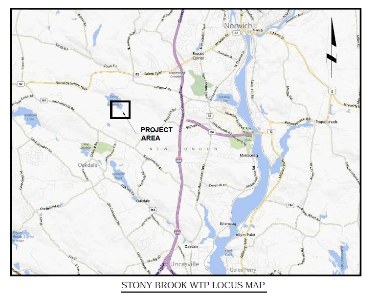
1. Notice of Scoping for the Stony Brook Water Treatment Plant Facility Upgrades
Municipality where proposed project might be located: Montville
Address of Possible Project Location: 260 Cherry Lane
Project Description: Norwich Public Utilities is improving the Stony Brook surface Water Treatment Plant (WTP) by retrofitting the existing non-buoyant filter media contact clarifiers with Dissolved Air Flotation (DAF) clarifier units. The retrofit will be housed in a building addition adjoining the existing water treatment plant. The project also includes modifications to the interior and exterior piping as required to accommodate the proposed retrofit. There will be no change in the production capacity of the WTP.
Project Maps: Click here to view a map of the project area. Click here to view a schematic of the proposed building addition.
Written comments from the public are welcomed and will be accepted until the close of business on: Friday, November 7, 2014.
Any person can ask the sponsoring agency to hold a Public Scoping Meeting by sending such a request to the address below. If a meeting is requested by 25 or more individuals, or by an association that represents 25 or more members, the sponsoring agency shall schedule a Public Scoping Meeting. Such requests must be made by October 17, 2014.
Written comments and/or requests for a Public Scoping Meeting should be sent to:
| Name: | Mr. Eric McPhee |
| Agency: | Department of Public Health |
| Drinking Water Section | |
| Address: | 410 Capitol Avenue, MS #51WAT |
| PO Box 340308 | |
| Hartford, CT 06134-0308 | |
| Fax: | 860-509-7359 |
| E-Mail: | DPH.SourceProtection@ct.gov |
If you have questions about the public meeting, or other questions about the scoping for this project, contact:
| Name: | Patricia Bisacky |
| Agency: | Department of Public Health |
| Drinking Water Section | |
| Address: | 410 Capitol Avenue, MS #51WAT |
| PO Box 340308 | |
| Hartford, CT 06134-0308 | |
| Phone: | 860-509-7333 |
| Fax: | 860-509-7359 |
| E-Mail: | Patricia.Bisacky@ct.gov |
The Following Environmental Impact Evaluation has been submitted for publication in this edition.
1. Notice of EIE for Farmington Water Pollution Control Facility Expansion & Upgrade
Municipality where project is proposed: Farmington
Address of Project Location: 921 Farmington Avenue, Farmington
Project Description: In order to meet current environmental regulations and projected growth, the Farmington Water Pollution Control Facility (WPCF) will require an expansion and upgrade. Overall wastewater flow and pollutant loads to the plant are projected to increase by approximately 35% by 2035. This increase is based on wastewater treatment capacity allotments requested by the Town and its contract communities (Avon, Burlington and Canton), and accounts for the planned connection of the following:
- residential, industrial and commercial flows within the Town of Farmington
- increased flows from the UCONN Health Center
- additional flows from Miss Porter's School
- additional flows from Westfarms Mall
- flows committed to the Towns of Avon, Canton and Burlington by inter-municipal agreement
- additional infiltration and inflow associated with planned sewer extensions as well as continued deterioration of the existing collection system.
As a result of the aging system, stricter environmental regulations that include nutrient removal, and projected increased flows, the town and their Water Pollution Control Authority proactively elected to evaluate and plan for improvements to the WPCF.
Project Maps: Click here to view a map of the project location.
Click here to view the site plan.
Click here to view a map of the sewer service area.
Comments on this EIE will be accepted until the close of business on: December 19, 2014
The public can view a copy of this EIE at:
Farmington Town Clerk
1 Monteith Drive
Farmington, CT 06032
The EIE can also be found online at the DEEP website by clicking here.
Any person can ask the sponsoring agency to hold a Public Hearing on this EIE by sending such a request to the address below by November 14, 2014. If a hearing is requested by 25 or more individuals, or by an association that represents 25 or more members, the Department of Energy & Environmental Protection must schedule a Public Hearing.
Send your comments about this EIE to:
| Name: | Stacy Pappano |
| Agency: | Department of Energy & Environmental Protection |
| Bureau of Water Protection & Land Reuse | |
| Address: | 79 Elm Street |
| Hartford, CT 06106-5127 | |
| Phone: |
860-424-3362 |
| Fax: | 860-424-4067 |
| E-Mail: | stacy.pappano@ct.gov |
If you have questions about a public hearing, or where you can review this EIE, or similar matters, please contact Ms. Pappano, as directed above.
The Connecticut Department of Energy and Environmental Protection is an Affirmative Action/Equal Opportunity Employer that is committed to complying with the requirements of the Americans with Disabilities Act. Any person with a disability who may need a communication aid or service may contact the agency's ADA Coordinator at 860-424-3194 or at deep.hrmed@ct.gov. Any person with limited proficiency in English, who may need information in another language, may contact the agency's Title VI Coordinator at 860-424-3035 or at deep.aaoffice@ct.gov. ADA or Title VI discrimination complaints may be filed with DEEP’s EEO Manager at (860) 424-3035 or at deep.aaoffice@ct.gov.
Connecticut General Statutes Section 4b-47 requires public notice of most proposed sales and transfers of state-owned lands. The public has an opportunity to comment on any such proposed transfer. Each notice includes an address where comments should be sent. Read more about the process.
The Following State Land Transfer Notices have been submitted for publication in this edition.
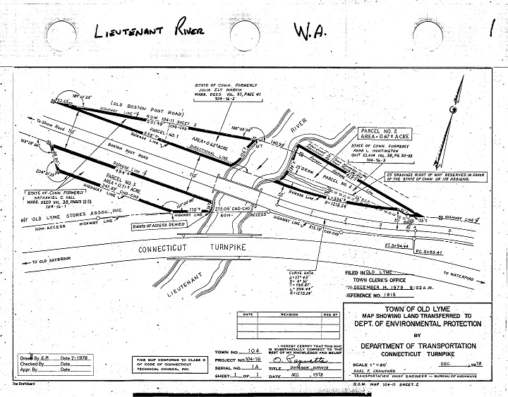
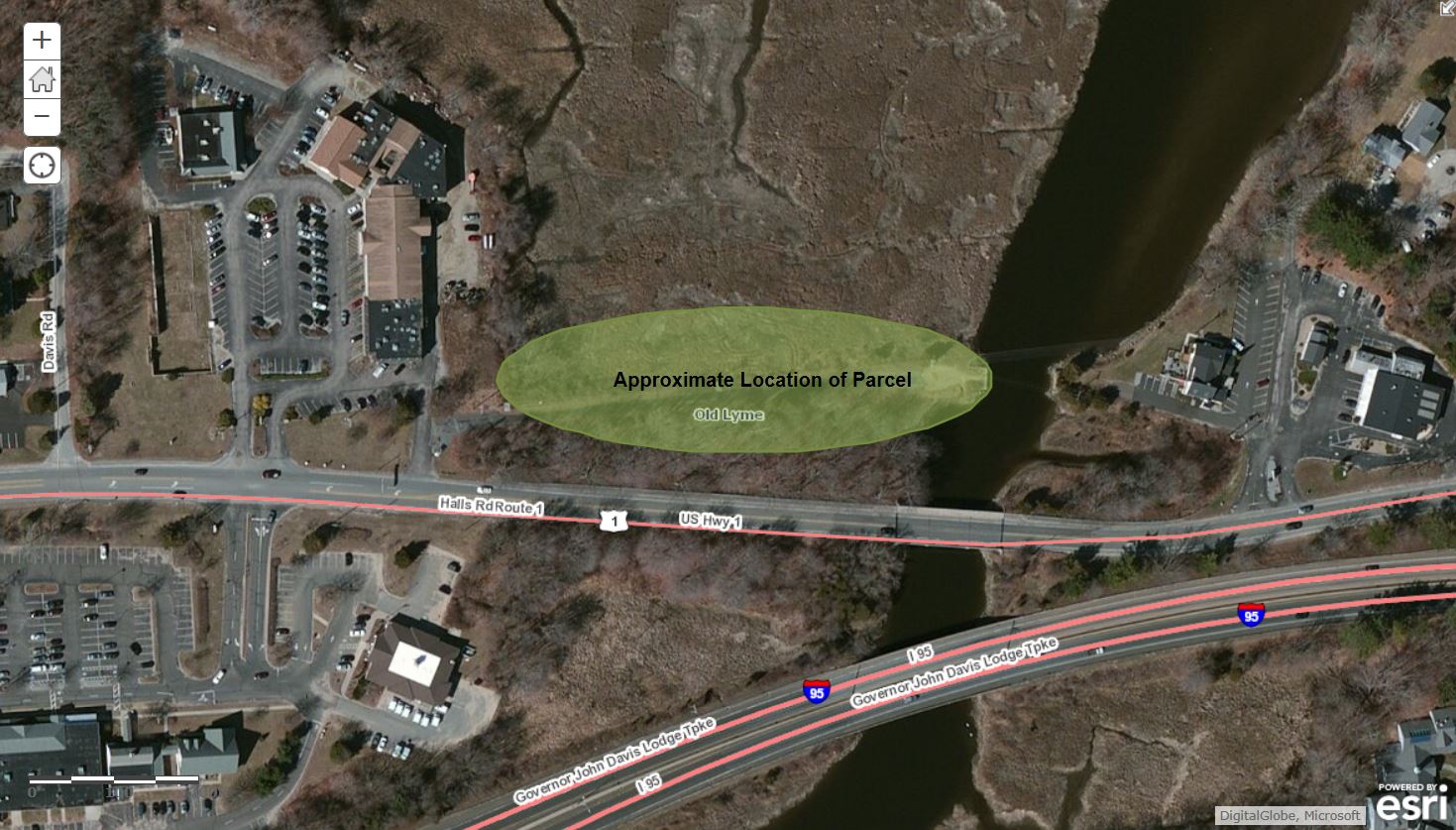
1. Notice of Proposed Land Transfer, Old Lyme
Complete Address of Property: Old Boston Post Road, Old Lyme
Number of acres to be transferred: 0.62 acres
Property Location and Survey: Click for: map, Click for: photo
Description of Property
Brief Description of Historical and Current Uses:
The parcel to be transferred to the Town of Old Lyme was historically under the custody and control of the Department of Transportation, and was associated with Route 1 and the prior Route 1 Bridge over the Lieutenant River. The parcel became surplus when it was no longer needed for highway purposes. In 1979, this parcel was transferred to the Department of Environmental Protection (now the Department of Energy and Environmental Protection or DEEP) for public access to the River. The Town would be able to combine this parcel with town-owned land to expand and enhance recreational opportunities and water access for the general public.
The property to be transferred contains the following:
| Buildings in use | |
| Buildings not in use | |
| Wooded land | |
| x | Nonagricultural fields |
| Active agriculture | |
| Paved areas | |
| Ponds, streams or other water |
| Water Supply: | Public water supply | On-site well | x | Unknown | ||
| Waste Disposal: | Served by sewers | On-site septic system | x | Unknown |
The Connecticut Conservation and Development Policies Plan identifies the property as being in the following category:
| Regional Center | |
| Neighborhood Conservation Area | |
| Growth Area | |
| Rural Community Center | |
| Rural Area | |
| x | Conservation Area |
| Preservation Area | |
| Existing Preserved Open Space |
The property is in the following municipal zone:
| Not zoned | |
| Residential | |
| Industrial | |
| Commercial | |
| Institutional | |
| Other: | |
| x | Not known |
Type of Sale or Transfer:
| x | Sale or transfer of property in fee |
| Sale or transfer of partial interest in the property (such as an easement). Description of interest: |
Proposed recipient, if known: Town of Old Lyme
Proposed use by property recipient, if known: The Town of Old Lyme has proposed to enhance this public water access area. The area will be open to the public, regardless of residency. The Town will fund any needed infrastructure and the maintenance of the property.
The agency is proposing to transfer the property with the following restrictions on future uses: DEEP will convey the land with the following restrictions in the deed: the property must be open to the public, regardless of residency, the Town of Old Lyme must use the property solely for public recreation purposes, and the property will revert to DEEP if either condition is violated.
| If checked, the state is not currently proposing restrictions on future uses. |
Reason the State of Connecticut is proposing to transfer this property: The Town of Old Lyme is best-suited to enhance and maintain this small, standalone property for public use and benefit. If the property is not used for public recreation, it will revert to DEEP.
Comments from the public are welcome and will be accepted until the close of business on: NOVEMBER 20, 2014
Comments may include information that you have about significant natural resources or recreation resources on the property, as well as your recommendations for means to preserve such resources.
Written comments* should be sent to:
|
Name: |
Patrick O’Brien |
|
Title: |
Bureau of Assets Management |
|
Agency: |
Office of Policy and Management |
|
Address: |
450 Capitol Avenue MS#52 ASP |
| Hartford, CT 06106-1379 | |
|
E-Mail: |
Patrick.Obrien@ct.gov |
*E-Mail submissions are preferred.
What Happens Next
When this comment period closes, the proposed land transfer can take one of three tracks:
- If no public comments are received, the sale or transfer can proceed with no further public comment and no further notices in the Environmental Monitor, unless the Department of Energy and Environmental Protection elects to conduct a review of the property (see #3).
- If public comments are received, the Office of Policy and Management will respond to those comments. The comments and responses will be published in the Environmental Monitor. Fifteen days after publication of the comments and responses, the proposed sale or transfer can proceed, unless the Department of Energy and Environmental Protection elects to conduct a review of the property (see #3).
- If the Department of Energy and Environmental Protection (DEEP) elects to conduct a further review of the property, it may submit to the Office of Policy and Management a report with recommendations for preserving all or part of the property. The report and recommendations will be published in the Environmental Monitor, and there will be a 30-day public comment period. The DEEP will publish its responses to any comments received and its final recommendation about the property in the Environmental Monitor. The Office of Policy and Management will then make the final determination as to the ultimate disposition of the property, and will publish that determination in the Environmental Monitor. Fifteen days after publication of that final determination, the sale or transfer can proceed.
To find out if this proposed transfer is the subject of further notices, check future editions of the Environmental Monitor. Sign up for e-alerts to receive a reminder e-mail on publication dates.
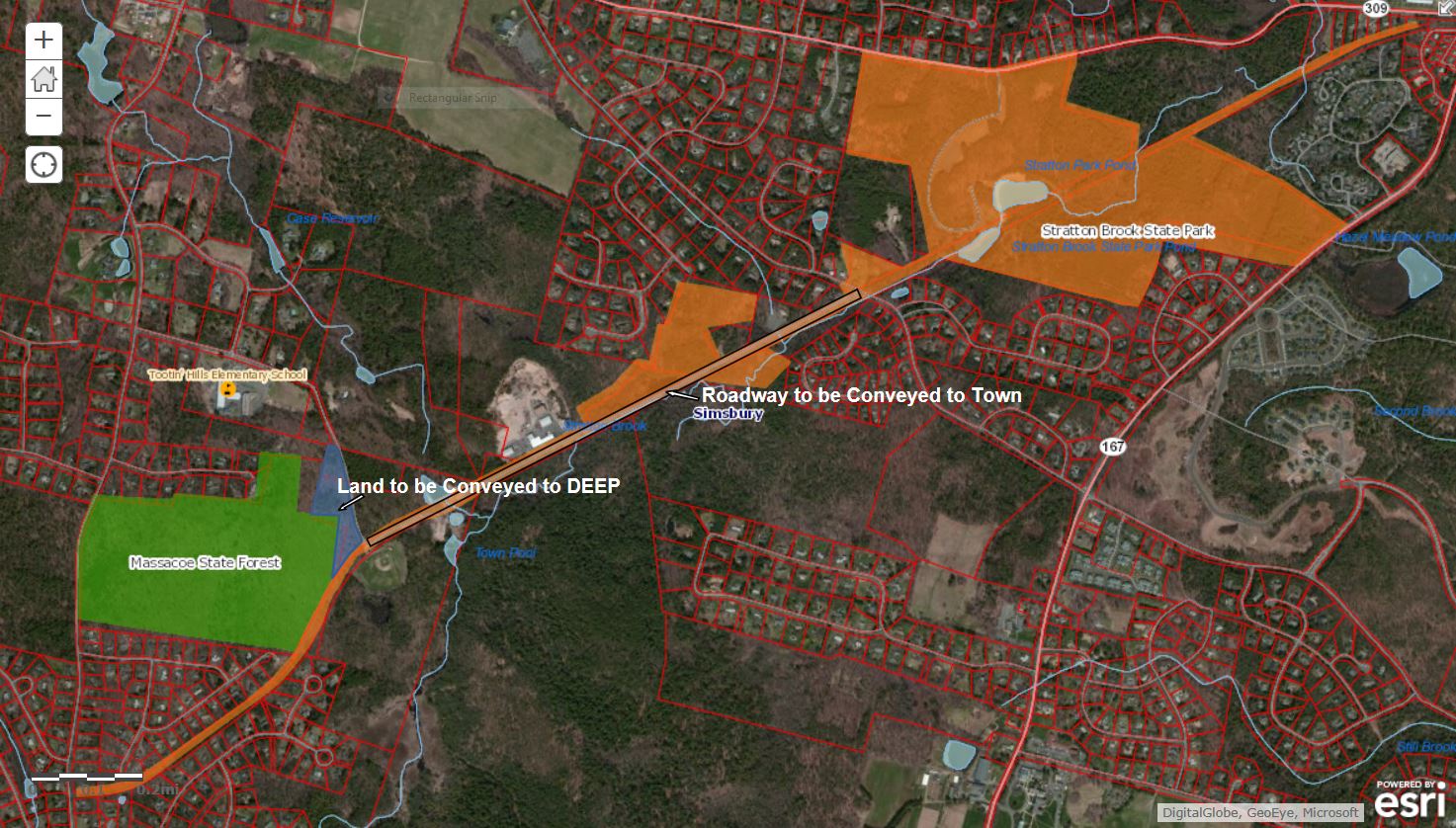
2. NOTICE OF PROPOSED LAND TRANSFER, SIMSBURY
Complete Address of Property: Town Forest Road, Simsbury
Number of acres to be transferred: 10.181 acres
View: map
Description of Property
Brief Description of Historical and Current Uses: The Town of Simsbury has requested control of an existing public road known as Town Forest Road. A portion of this road, between Stratton Brook Road and Nimrod Road, is owned by the Department of Energy and Environmental Protection (DEEP) and is used as a public road with no dedicated use by DEEP for any business or recreational purpose. The road currently terminates at Town Forest Park, land owned by the Town of Simsbury. DEEP acquired this former rail line in 1941, as a part of its acquisitions that now comprise Stratton Brook State Park. The developed Park lands and trails are located on across Stratton Brook Road to the northeast.
The property to be transferred contains the following:
| Buildings in use | |
| Buildings not in use | |
| Wooded land | |
| Nonagricultural fields | |
| Active agriculture | |
| x | Paved areas |
| Ponds, streams or other water |
| Water Supply: | Public water supply | On-site well | x | Unknown | ||
| Waste Disposal: | Served by sewers | On-site septic system | x | Unknown |
The property is in the following municipal zone
| x | Not zoned |
| Residential | |
| Industrial | |
| Commercial | |
| Institutional | |
| Other: | |
| Not known |
Value of property, if known:
| x | If checked, value is not known. |
Type of Sale or Transfer:
| x | Sale or transfer of property in fee |
| Sale or transfer of partial interest in the property (such as an easement). Description of interest: |
Proposed recipient, if known: Town of Simsbury
Proposed use by property recipient, if known: The Town of Simsbury will continue to use this road as it is currently used as a public roadway. As owner of the road, they intend to install public utilities in the road to service town facilities, including Tootin’ Hills Elementary School on Nimrod Road.
The agency is proposing to transfer the property with the following restrictions on future uses: The requirement that the Town will maintain the parcel as a Town road allowing the general public to pass and repass. The Town shall also mark the pavement and provide signage indicating that the road is to be shared with bicyclist and pedestrians.
| If checked, the state is not currently proposing restrictions on future uses. |
Reason the State of Connecticut is proposing to transfer this property: The Town of Simsbury has requested ownership of this public roadway, which has been maintained by the Town for public use. In exchange, the Town is proposing to provide DEEP with 6.672 acres of land that abuts Massacoe State Forest. DEEP accepts this proposal, as access to all DEEP land will continue with the Town’s ownership of Town Forest Road and DEEP will no longer have the responsibility for maintaining a public roadway that has no dedicated use for DEEP business purposes or recreation.
Comments from the public are welcome and will be accepted until the close of business on NOVEMBER 20, 2014
Comments may include information that you have about significant natural resources or recreation resources on the property, as well as your recommendations for means to preserve such resources.
Written comments* should be sent to:
|
Name: |
Patrick O’Brien |
|
Title: |
Bureau of Assets Management |
|
Agency: |
Office of Policy and Management |
|
Address: |
450 Capitol Avenue MS#52 ASP |
|
Hartford, CT 06106-1379 |
|
|
E-Mail: |
Patrick.Obrien@ct.gov |
*E-Mail submissions are preferred.
Additional information, if any: Delete this line if you have no additional information!
What Happens Next
When this comment period closes, the proposed land transfer can take one of three tracks:
- If no public comments are received, the sale or transfer can proceed with no further public comment and no further notices in the Environmental Monitor, unless the Department of Energy and Environmental Protection elects to conduct a review of the property (see #3).
- If public comments are received, the Office of Policy and Management will respond to those comments. The comments and responses will be published in the Environmental Monitor. Fifteen days after publication of the comments and responses, the proposed sale or transfer can proceed, unless the Department of Energy and Environmental Protection elects to conduct a review of the property (see #3).
- If the Department of Energy and Environmental Protection (DEEP) elects to conduct a further review of the property, it may submit to the Office of Policy and Management a report with recommendations for preserving all or part of the property. The report and recommendations will be published in the Environmental Monitor, and there will be a 30-day public comment period. The DEEP will publish its responses to any comments received and its final recommendation about the property in the Environmental Monitor. The Office of Policy and Management will then make the final determination as to the ultimate disposition of the property, and will publish that determination in the Environmental Monitor. Fifteen days after publication of that final determination, the sale or transfer can proceed.
To find out if this proposed transfer is the subject of further notices, check future editions of the Environmental Monitor. Sign up for e-alerts to receive a reminder e-mail on publication dates.
Access.Adobe is a tool that allows blind and visually impaired users to read any documents in Adobe PDF format. For more information, read the product overview at Adobe.com .