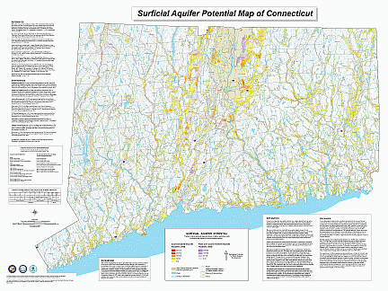
The Surficial Aquifer Potential Map of Connecticut has been prepared by the Connecticut Geological Survey for statewide resource protection, water management, non-point source pollution prevention, and land use planning. The map was compiled from a geospatial analysis of the surficial materials and thickness of glacial sediments digital data layers of the Surficial Materials Map of Connecticut, Stone and others (1992) and Quaternary Geologic Map of Connecticut and The Long Island Sound Basin, Stone and others (1998, 2005).
The map identifies areas with greater potential for ground water supply based upon the texture and thickness of surficial aquifer deposits. The resulting hydrostratigraphic units define areas of coarse grained deposits, coarse overlying fine grained deposits, fine grained deposits, and areas where fine grained deposits overlie coarse grained deposits. Aquifer deposit thickness intervals are 1-50 feet, 50-100 feet, 100-200 feet, 200-300 feet, and 300-400 feet.

The Aquifer Potential Map of Connecticut is suitable for regional and statewide water resource planning at 1:125,000 scale, and may be a useful tool for watershed classification relative to potential ground water availability. The map does not include information on saturated thickness, or depth to ground water.
The CT Surficial Aquifer Potential Map is available for downloading in several formats:
Please note: This map is a large file and may take some time to view. It is recommended that you save the file(s) to your local computer for viewing and printing. Also note that the page size is 48"x36" landscape, printable on Arch E size plotter paper.
This project was supported by the DEP Nonpoint Source Management Program, through the Federal Clean Water Act Section 319 administered by the US EPA. For more information on aquifers, please visit Connecticut’s Aquifers or call (860) 424-3020.
Content Last Updated January 2008

