
EarthCache Sites
EarthCache Sites Developed by the Connecticut Geological Survey (CGS)
| Graphic | EarthCache Sites |
|---|---|
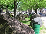 |
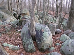
Art is in the Eye of the Beholder! (Hartford) |
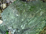
| In 1977 a commissioned stone sculpture consisting of 36 large stones was installed in a small park in the city of Hartford. This art installation provides us an opportunity to make some geologic observations in the middle of a city where bedrock does not outcrop at the surface. |
| Graphic | EarthCache Sites |
|---|---|
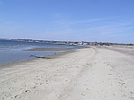 |
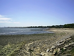
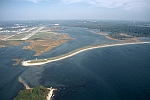
Beach Migration at Hammonasset (Hammonasset Beach State Park, Madison)
Coastal Feature |
| The beach is a dynamic environment. It is constantly changing. The natural forces of change on the beach are waves, wind, and locally, tidal currents. This EarthCache explores the natural changes that continually shape and reshape the beaches. |
| Graphic | EarthCache Sites |
|---|---|
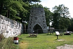 |
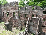
Beckley Blast Furnace (Beckley Furnace Industrial Monument, North Canaan) Mining Site |
|
The Beckley Blast Furnace was one of more than 40 blast furnaces and foundries that took advantage of the key natural resources located in this area to make iron and manufacture products such as railroad wheels and cannons. This EarthCache explores the connection between local geology and industry.
|
| Graphic | EarthCache Sites |
|---|---|
 |
Bolton Notch Caves (Bolton Notch State Park, Bolton) Cave/Karst Feature |
|
Bolton Notch is one of two significant breaks in the Bolton Range, which stretches from the Middletown area northward into Massachusetts. The Notch was eroded by glacial melt-water that flowed eastward through a fault and fracture zone. In the process it exposed a layer of rocks containing relatively soluble carbonate minerals. This EarthCache is about one of the results of soluble rock layers: caves!
|
| Graphic | EarthCache Sites |
|---|---|
 |
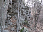
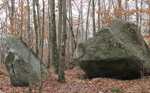
Boulder Hopping at Glacial Park (Ledyard) Geomorphological Feature |
|
A unique concentration of large and small boulders is found draping over the top of a couple of hills and in the intervening ravine at Glacial Park. This boulder field is about 100 yards wide and a little less than a mile in length. A much less concentrated line of discontinuous boulders stretches eastward from Hammonasset Beach State Park to Ledyard and into western Rhode Island. The entire area is part of what geologists refer to as a recessional moraine.
|
| Graphic | EarthCache Sites |
|---|---|
 |
Footprints of the Devil? (Devil's Hopyard State Park, East Haddam) River Feature |
|
The Eightmile River cascades about 60 feet down a series of falls and rapids at Chapman Falls in Devil’s Hopyard State Park in East Haddam, CT. In the process, it has drilled several spectacular potholes. This EarthCache investigates those potholes.
|
| Graphic | EarthCache Sites |
|---|---|
 |
Soft Rock vs Hard Rock (Haystack Mountain State Park, Norfolk) Erosional Feature |
|
Rocks that formed the eastern edge of the ancient North American continent 600 million years ago today underlie the western part of Connecticut. They are composed of schist, marble, and gneiss, including amphibole gneiss. This EarthCache will focus on the general weathering properties of these old rocks by comparing the rate of weathering of marble with that of granite.
|
| Graphic | EarthCache Sites |
|---|---|
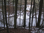 |
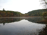
After the Ice Age (Mansfield Hollow State Park, Mansfield) Glacial Feature |
|
This EarthCache will observe post-glacial sediments that were deposited in Mansfield Hollow State Park at the end of the last Ice Age. You will observe the shape they give to the land and explore how and in what sequence the sediments were formed.
|
| Graphic | EarthCache Sites |
|---|---|
 |
Landforms near Mount Riga (Mount Riga State Park, Salisbury) Glacial Feature |
| Mt. Riga State Park is one of Connecticut’s undeveloped state parks. The Undermountain Trail, is the only public trail in the park and is used to access the Appalachian Trail to the west. Boulders in the area pose an interesting glacial geologic puzzle. |
| Graphic | EarthCache Sites |
|---|---|
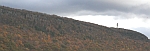 |
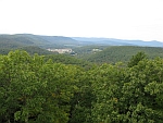
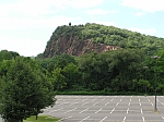
Oh Say, How Far Can You See… (Talcott Mountain State Park, Bloomfield) |
|
Talcott Mountain is one part of the trap-rock ridge system in central Connecticut. The ridge is formed by basalt (an igneous rock) that resisted the grinding erosion of the ice age glaciers and was left standing high above those areas underlain by more easily erodible sedimentary rocks. One result of that erosion is the spectacular views of the Connecticut valley and the trap-rock ridge system.
|
| Graphic | EarthCache Sites |
|---|---|
 |
Old Newgate Mine (East Granby) Mining Site |
|
Copper was first discovered in the Newgate area in 1705. Several attempts were organized to exploit the deposit, but none proved especially profitable. The tunnels that were driven into the rock were used as a prison during the Revolutionary War. This EarthCache will investigate some of the mine workings.
|
| Graphic | EarthCache Sites |
|---|---|
 |
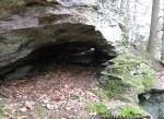
Shelter Caves(Chatfield Hollow State Park, Killingworth) Geomorphological (Landscape) Feature |
|
The rock in Chatfield Hollow State Park is granite gneiss with minor pegmatite and a few quartz veins. The rock has an interesting set of fractures that has led to the formation of shelter-caves through frost wedging and rock fall. The caves are referred to as shelter caves. This EarthCache explores some of the features of these caves.
|
| Graphic | EarthCache Sites |
|---|---|
 |
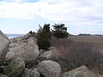
Coastal Geology (Sherwood Island State Park, Westport) Coastal Feature |
|
Sherwood Island State Park is home to some interesting Connecticut State geology. Although there is a lack of actual rock outcrops, coastal geology is an important aspect of the park's distinctiveness. This EarthCache will explore some glacial features along with coastal erosional and depositional features.
|
| Graphic | EarthCache Sites |
|---|---|
 |
Is This A Tombolo? (Silver Sands State Park, Milford) Coastal Feature |
|
A tombolo is a depositional land-form that creates a narrow neck of land connecting an offshore rock or island with the mainland. Sand is deposited in such a fashion because waves refract (bend) around both sides of the island and thus wash sand toward the middle, where it is deposited. Charles Island at Silver Sands State Park is connected to the mainland beach by a gravel bar. Although it is referred to as a tombolo, it appears more that it is left behind from erosion rather than deposited. We will explore that notion in this EarthCache.
|
| Graphic | EarthCache Sites |
|---|---|
 |
Step into the Early Jurassic (Dinosaur State Park, Rocky Hill) Fossil Site |
|
Dinosaur State Park has one of the largest on-site displays of dinosaur tracks in the world. This EarthCache will investigate the unique rock formation that contains these tracks and will examine the concept of time on a geologic scale.
|
| Graphic | EarthCache Sites |
|---|---|
 |
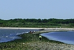
Part I: The Changing Beach (Bluff Point State Park, Groton) Coastal Feature |
|
Beaches are accumulations of granular material (sand and gravel) along the shore of a body of water. Granular material is easily moved as a result of the physical processes of water and wind in the shoreline environment. This EarthCache explores the natural processes that occur on the east end of the Bluff Point State Park beaches and some of the changes that have occurred there. A companion EarthCache explores the changes that have occurred along the west end of the beach. A separate EarthCache explores the geology of Bluff Point.
|
| Graphic | EarthCache Sites |
|---|---|
 |
Part II: Sand on the Move (Bluff Point State Park, Groton) Coastal Feature |
|
This is a companion EarthCache to Bushy Point Part I, which looked at several beach processes and how they change the shape of the beach at Bluff Point State Park. Waves, wind and tidal currents are the main agents of change on a beach. The sum-total of changes on the beach results in migration of the beach. This EarthCache explores historical records to document beach migration at Bushy Point Beach.
|
| Graphic | EarthCache Sites |
|---|---|
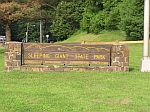 |
The Giant Sleeps Today (Sleeping Giant State Park, Hamden)
Igneous (Volcanic) Feature |
|
Have you ever walked on a Sleeping Giant? Local folklore tells of an ancient Indian Chief who over indulged eating oysters and offended the spirits. A spell was cast upon the Chief while he slept never to awake. Sleeping Giant is one of the state's most recognizable land formations. This EarthCache investigates how Sleeping Giant formed as intrusive sheets of magma cooled.
|
| Graphic | EarthCache Sites |
|---|---|
 |
The Meeting of Two Rivers (Farmington) River Feature |
| This EarthCache takes place where the Pequabuck River drains into the Farmington River. This meeting of two rivers is called a confluence. Every time this occurs, it increases the river’s flow rate and affects its ability to transport nutrients, sediment, and pollutants along the river. These changes can be observed and measured. |
| Graphic | EarthCache Sites |
|---|---|
 |
The Mystic Moraine (Bluff Point State Park, Groton) Coastal Feature |
|
This EarthCache explores the glacial geology and some differences in the types of rocks found at Bluff Point State Park. Two companion EarthCaches explore the beach dynamics at the Bluff Point-Bushy Point Beach.
|
| Graphic | EarthCache Sites |
|---|---|
 |
Cliffs and Glaciers at West Rock (West Rock State Park, New Haven)
Igneous (Plutonic) Feature |
| Rising up to 627 feet above mean sea level, West Rock Ridge is one of the most prominent features of the New Haven region. It is composed of igneous rock that formed when magma intruded into sedimentary rocks and cooled between 220-200 million years ago. This EarthCache investigates this unique feature and the effect of glacial activity during the last Ice Age (about 20,000 years ago). |
| Graphic | EarthCache Sites |
|---|---|
 |
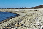
Why Are Boulders at Meigs Point? (Hammonasset Beach State Park, Madison)
Glacial Feature |
|
The landscape and surficial materials (soils etc.) at Hammonasset Beach State Park are all relatively young, geologically speaking. Although there are lots of stones of various sizes, there is no bedrock (ledge) exposed in the park. Instead we mostly find sandy beaches with some gravel and muddy marshes. An abundance of large stones, however, are found at Meigs Point. This EarthCache focuses on the surficial geology at Meigs Point.
|
| Graphic | EarthCache Sites |
|---|---|
 |
Sulfide Caves in Devil's Hopyard: Karst Features? (East Haddam)
Erosional Feature |
|
The Devil’s Hopyard State Park is underlain by schist and gneiss that contain significant amounts of sulfide minerals such as pyrite. When pyrite is exposed to water it weathers according to a chemical reaction, forming rust and sulfuric acid. The rock is rendered weaker. Sulfuric acid then dissolves other constituents of the rock. This EarthCache explores some examples of cave formation associated with sulfide weathering of the Brimfield Formation at the Devil’s Hopyard State Park. Geology of Devil's Hopyard State Park |
| Graphic | EarthCache Sites |
|---|---|
 |
The Glaciers Went Here! (Glastonbury)
Glacial Features |
|
When glaciers traveled across New England in the last Ice Age, they left their mark! This EarthCache explores some of the evidence left behind that tells us where they came from and how they affected the landform in this area. |
| Graphic | EarthCache Sites |
|---|---|
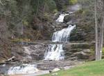 |
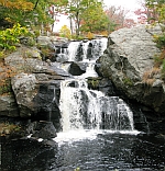
Structure of a Waterfall (Kent)
|
|
Kent Falls is one of the highest waterfalls in Connecticut. Kent Falls Brook cascades about 250 feet over a distance of almost a quarter mile. The highest single drop, however, is only about 40 feet. Nonetheless it is a spectacular natural site in Connecticut. This EarthCache explores the erosional and tectonic forces that created one of the highest waterfalls in Connecticut. Geology of Kent Falls State Park
|