
Letterboxing Clues for Camp Columbia State Forest
Connecticut State Forests - Seedling Letterbox Series - Clues for Camp Columbia State Forest
| Location Map | State Forest Information | Letterbox Stamp |
|---|---|---|
|
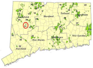
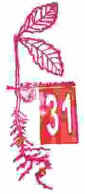
Camp Columbia State Forest – the 31st State Forest |
|
Camp Columbia State Forest and State Historic Park is one of Connecticut DEEP’s most recent land acquisitions. This is the first DEEP letterbox at Camp Columbia. Located by Bantam Lake in Morris and Bethlehem, this “small” 600-acre property was acquired from Columbia University in 2000 and dedicated in 2004.
In 1903, Columbia University purchased farmland to serve as a summer camp for Columbia University’s surveying and engineering students. Ironically for a future “state forest”, there were practically no trees on the property in those days! For 80 years, students used the grounds of Camp Columbia to put their classroom skills to practical use, sometimes even resulting in engineering breakthroughs. A demonstration of a new method of construction using a pre-stressed concrete roof with no interior supports was later tested on a much larger scale with the construction of Madison Square Garden in New York City! The university football team also practiced here, and Dwight D. Eisenhower is one of the dignitaries who reportedly hunted on the property during the 20th Century.
During World War I, the Camp was used for combat training for college students that planned to apply for commissions as officers. Captain Ralph Williams of the Canadian Light Infantry, a decorated veteran of the French and Belgian fronts, was in charge of the program. Students were forced to march, drill, dig trenches, and fight in simulated warfare that included real as well as dummy gunfire and explosives. Even today, subtle remnants of trenches dug in 1917 and 1918 are still evident in various parts of the property. Camp Columbia closed in 1983, and has since remained relatively quiet.
Every new state property must undergo a period of scrutiny to determine the best public use based on location, past use, resources present, access, and other factors. The majority of this parcel was designated "State Forest", because the property has a history of active forest management and hunting. A state forest is managed for such multiple uses as the growth and harvest of forest products, wildlife habitat enhancement, research, hunting and trapping, hiking, etc. A small portion of the acreage that includes the frontage on Bantam Lake and the site of Columbia University's former campus was designated as a "State Historic Park" due to the historic and unique character of those areas.
Description: The letterbox lies in a roadside stone wall off Munger Lane, a town road in Morris. It is a very quick hike, and possibly one of the shortest available. Since the letterbox is in the state forest portion of the property where regulated hunting is permitted, you are advised to wear bright orange during fall hunting season. Parking is limited, and there may be no simple place to park when there is snow on the ground. Ticks are in abundance at Camp Columbia most of the year, but most notably in spring, early summer and mid to late fall. You should wear light-colored clothing sprayed with repellent and check yourself frequently. Remember that the ticks can be very tiny!
CLUES: To find the area by map, you will want to reach the junction of Route 109 and 209. This is west of the center of Morris and just west of the public parking area at the wooden shield sign for Camp Columbia. At 109/209, go another half-mile on 109 past the junction and take a left onto Todd Hill Road.
On Todd Hill, you will pass an old cemetery on the right immediately. Follow Todd Hill Road a total of 4/10-mile and take a left onto Munger Lane (drive slowly, the turn comes up quickly). Follow Munger Lane until the pavement ends. Once Munger turns into a gravel/dirt road, proceed another 2/10-mile and look for the gapway through a stone wall on your right, and a brown sign reading “Selection Cut”, nailed to a hickory tree. (Note that snow plowing may stop at the end of the pavement in winter, and you may have to park there and walk up the road. You are advised to not attempt driving the unmaintained portion of the road in winter, and you should also not block the road when you park your vehicle.)
The letterbox is located in a crevice of large stones, in the stone wall behind and next to this “Selection Cut” sign. To find it, you will have to look on the back side of this wall, not the road side of it. At the hickory with the sign, it would be a bearing of N45W, only 5 feet away.
When done, be sure to thoroughly re-bag it to keep the contents dry and don’t leave completely exposed. It is okay to replace small rocks or debris in front of it.
While here, look around—this area was the site of a timber harvest completed in 2015. The grassy opening near your letterbox was the “landing” or staging area for the entire logging operation. That means all logs and firewood pulled out of the 30 acres were sorted and stacked here for loading on log trucks. But you would probably never know it now! If visiting in summer, this is a dense thicket of new herbaceous vegetation, including native flowers for pollinators.
This forestry work was selection cutting (as the sign explains) to convert an area of forest to “uneven-aged management”. This means the Forestry Division is creating an area with multiple distinct age classes at the same time. To achieve this, varied-size openings are created in the forest canopy, from one tree crown in size up to a half-acre in size. This encourages some new forest growth of tree species that are both tolerant and intolerant of shade. The poorest quality and least healthy trees are removed, to promote a healthier and more productive forest with the best genetic quality of seed left in the woods. Look around—how many different types of trees do you notice? Do you see the different size openings made? How does the vegetation and types of saplings vary in very small, tight openings vs. the much larger ones? No more harvesting will take place in this same area until at least 2035!
Learn More, Earn a Patch: DEEP hopes you enjoyed your visit to Camp Columbia State Forest. If you have the time, visit the public parking area on Route 109 and go for a hike. There are about 3 miles of trails to explore, as well as a stone tower to climb. A trail map is available.
This is one of 32 letterbox hikes in the new second series of boxes, called the “Seedling Series”, sponsored by the Connecticut Department of Energy and Environmental Protection’s Division of Forestry. Take 4 additional sponsored letterbox hikes to earn a commemorative Connecticut Forestry letterbox patch. When you have completed five of these hikes, please contact us and let us know what sites you have visited, what your stamp looks like and how we may send your patch. We will verify your visits and send the patch along to you.
Content last updated September 13, 2021