
Dooley Pond 2004
Dooley Pond, Middletown - 2004
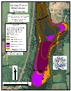
2004 Aquatic Plant Survey Map of Dooley Pond
Located in Middletown, 18.5-acre Dooley Pond has a maximum depth of 16.5 feet near a dam on the pond’s north end, and the mean depth is 7.2 feet. The dam was built to create the pond, which is supplied by springs and water flowing in from Long Hill Brook on the south end. Water in the pond is eutrophic, and algae commonly become abundant during summer months. The state maintains a boat launch on the pond’s north shore.
Only five aquatic plant species were found in Dooley Pond during a June 2004 survey, and two of these, Eurasian watermilfoil (Myriophyllum spicatum)and curlyleaf pondweed (Potamogeton crispus), were invasive species. The other three species were small pondweed (Potamogeton pusillus), western waterweed (Elodea nuttallii), and coontail (Ceratophyllum demersum).
Water less than 3 feet deep around the edge of the pond was dominated by coontail and western waterweed, with small patches or individual occurrences of Eurasian watermilfoil, curlyleaf pondweed, and small pondweed. The south end of the pond was densely vegetated. Eurasian watermilfoil dominated areas with 3 to 9 feet of water. A patch of western waterweed was found in the middle of the pond at a depth of 9 feet. The pond’s north end was sparsely vegetated, and no vegetation at all was found in some areas where the bottom of the pond dropped off steeply to 15 feet.
| Species recorded in our 2004 survey of Dooley Pond. Scientific Names *Invasive Species |
|
| Coontail | Small pondweed |
| Curlyleaf pondweed* | Western waterweed |
| Eurasian watermilfoil* | |
Other Dooley Pond Surveys: 2015