
Ashford Lake 2006
Ashford Lake, Ashford - 2006
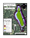
2006 Aquatic Plant Survey Map of Ashford Lake
Transect Data | Water Data
Aquatic vegetation viewable from the surface is minimal and poses minimal negative impacts on recreation. Patches of Bur-Reed (Sparganium species) are common along the shore, while needle spikerush (Eleocharis acicularis), quillwort (Isoetes species), yellow water lily (Nuphar variegata) and watershield (Brasenia schreberi)are sparse. A progression of plant species occur with increasing depth. Slender naiad (Najas flexilis) dominates areas from one to six feet deep; floating bladderwort (Utricularia radiata) occurs in six to nine feet of water, and leafy pondweed (Potamogeton foliosus) is present in water from nine to twelve feet. Residents have referred to the pondweed as a “grassy weed” and reported it as nearly reaching the surface in some years.
|
Species recorded in our 2006 survey of |
|
| Bur-Reed | Quillwort |
| Floating bladderwort | Slender naiad |
| Leafy pondweed | Watershield |
| Needle spikerush | Yellow water lily |
Other Ashford Lake Surveys: 2013 Survey