
Cold Water Stream Habitat Map
Cold Water Stream Habitat Map
Background
The Connecticut DEEP has developed methods to identify cold water stream habitat using both fish species as an environmental indicator and direct water temperature measurements. A study conducted by DEEP biologists and USGS published in the North American Journal of Fisheries Management 1 concluded that summer water temperature was important in defining cold water habitat in Connecticut streams. The study analyzed where fish community and stream water temperature were collected in the same location during the same season.

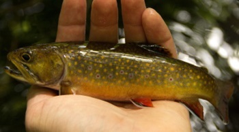
The study concluded that two native fish species, Brook Trout (Salvelinus fontinalis) and Slimy Sculpin (Cottus cognatus), when found in healthy populations, are dependent on cold water to live and therefore are important cold water indicator species in streams. Brook trout have been previously described as sentinel species for small, healthy least disturbed streams in Connecticut 2.
The research defined important water temperature thresholds, providing the ability to identify and classify areas of cold water stream habitat. For example, according to the research, if the average water temperature in a stream is 18.3 degree C (64.9 degrees F) or less from June through August, then it is habitat where cold water fish can survive. Another important finding was that small increases in the average summer water temperature can change a stream from cold water habitat to cool water to warm water habitat. This points out the vulnerability of cold water stream habitat to factors such as climate change. Small increases in the average summer water temperature of about 3 degrees C (6 degrees F) can move a stream from cold water habitat to warm water habitat. That means the stream will have completely different fish community if the average summer temperature increases slightly!
Methods Used to Develop a Comprehensive Map of Cold Water Stream Habitat Map for Connecticut
With the knowledge gained from the compilation of recent Connecticut based studies, identification and subsequent classification of cold water habitat can be made with data from either fish or stream water temperature. To catalog cold water habitat DEEP analyzed all available fish and water temperature data to identify cold water rivers and streams. The analysis to date includes years 1988 – 2023 and identified 1,716 samples and 792 sites indicating cold water habitat from both fish community and temperature logger data. If a site was measured to have cold water habitat with either fish community or water temperature using the June-August metric at any time during our surveys, it was considered cold water stream habitat. To present these data in a readily accessible and usable format, DEEP developed a web-based mapping application. The mapping application is easily updated as new or updated information is collected and analyzed.
Defining a cold water stream using fish community samples - Healthy populations of cold water species are considered samples with cold water fish species (i.e. Brook Trout and/or Slimy Sculpin) counts meeting or exceeding 10 fish/100 meters in this analysis. Stream sampling locations with 10 or more cold water fish/100 meters in a sampling event are included on the map.
Defining a cold water stream using water temperature loggers - A cold water stream is defined as having an average summer (June-August) water temperature of 18.3 degree C (64.9 degrees F) or less in this analysis. All stream sites that met this condition are included on the map.
The Cold Water Stream Habitat Map Application
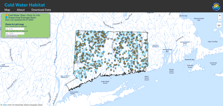
The Cold Water Stream Habitat Web based map application currently displays 792 cold water sites and supporting drainage basin which includes approximately 4,000 stream miles in Connecticut. This is a conservative baseline estimate since we have not sampled the all the streams in the state, so there is likely more cold water stream habitat that we still have not measured. The map will be updated periodically as new data are collected. Data that are used to make the map can be easily downloaded in several data formats directly from the map application for customized use and analysis.
Summary
- Brook Trout and Slimy Sculpin are important cold water stream habitat indicator species in Connecticut.The presence of either in healthy populations indicates cold water stream habitat and these data are included in the map application.
- The average summer (June-August) stream water temperature less than 18.3 degree C (64.9 degrees F) can also be used to classify cold water stream habitat. Rivers and streams where DEEP biologists and volunteers have measured water temperatures that meet this criterion are included in the map application.
- Data used in the Cold Water Stream Habitat Web based map application can be downloaded through the web application.
- Nearly 4,000 stream miles support cold water habitat in Connecticut.
- The information contained in the cold water map is not a model. Rather, the map is based on measurements in the field collected by many dedicated biologists and volunteers over several years.
- Small increases in the average summer water temperature, as few as 3 degrees C (6 degrees F), can move a stream from cold water habitat to warm water habitat. That means the stream will have completely different fish community! This points out the vulnerability of cold water stream habitat to climate change.
Literature Cited
1 Mike Beauchene, Mary Becker, Christopher J. Bellucci, Neal Hagstrom & Yoichiro Kanno. 2014. Summer Thermal Thresholds of Fish Community Transitions in Connecticut Streams, North American Journal of Fisheries Management, 34:1, 119-131, doi:10.1080/02755947.2013.855280.
2 Christopher J. Bellucci, Mary Becker, & Mike Beauchene. 2011. Characteristics of macroinvertebrate and fish communities from 30 least disturbed small streams in Connecticut. Northeastern Naturalist 18:411-444, doi.org/10.1656/045.018.0402.
Program Contact Information
Mary Becker
Water Monitoring and Assessment Program
79 Elm Street, Hartford, CT 06106
(860) 424-3262
mary.becker@ct.gov
Content last updated April 7, 2025