
Letterboxing Clues for Pachaug State Forest
Connecticut State Forests - Seedling Letterbox Series Clues for Pachaug State Forest
|
Pachaug State Forest - |
 |
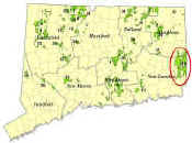
Pachaug State Forest, the largest of Connecticut’s 32 public forests, is over 27,000 acres with parcels located in the towns of Voluntown, Griswold, Plainfield, Sterling, North Stonington and Preston. Most of the land was purchased with federal and state funds during the Great Depression (1930’s) and managed initially by the Civilian Conservation Corps. Today the forest is actively managed for forest products and a wide range of recreational activities that include fishing, hunting, swimming, hiking, camping, dog sled racing and horseback riding. Additional information may be obtained at the forest office headquarters located off the main forest entrance road.
Description: The letterbox lies off the blue trail near the summit of High Ledge Lookout, in North Stonington. The hike is approximately 2 miles round trip, over hilly, rocky terrain that includes one steep stretch of trail. Estimated time for round trip is 1 ½ hours. Caution -sections of trail border steep rock outcrops. Trail may be slippery during wet weather. Wearing bright orange is encouraged during deer hunting season (November through December). As always, be aware of your surroundings. Dead trees in the forest can be a hazard, especially during high winds. A compass is helpful if you decide to continue on for the extra adventure!
This letterbox can be reached off of Wyassup Lake Road in North Stonington.
From the north and west: Take Exit 85 (Voluntown) off of I-395. Go east on Route 138 for approximately 9 miles. In the center of Voluntown, turn right onto Route 49 South. At 4.8 miles, you will cross the town line into North Stonington. Shortly thereafter, at 5.3 miles, take a right turn onto Wyassup Road. Follow Wyassup Road for 2.6 miles. Turn right onto Wyassup Lake Road. It will be 0.7 miles from this point to a green gate on the left side of the road. This will be the second gate that you pass along the way and is just past the Wyassup Lake boat launch, which is on the right side of the road. The green gate marks the start of your hike. Park on the side of the road by the gate. Do not block the gate.
From the south and east: Take Exit 92 (Rte 2, and Rte. 49) off of I-95. Head north on Route 49, either by taking a right off of the exit ramp from I-95 South, or a left at the end of the service road coming from I-95 North. Follow Route 49 North for approximately 6.6 miles. (You will cross Route 184 approximately 0.9 miles into drive, and you will pass the junction of Route 216 at approximately 2.9 miles). At 6.6 miles, turn left onto Wyassup Road. From this point on, follow directions as listed above from Wyassup Road.
Clues: Your journey begins as you walk up the road behind the gate. As you proceed up the woods road, you may note the boulders and ledges through the trees on the left side of the trail. These types of rocky areas are a part of North Stonington’s unique topography. Listen to the numerous bird calls – they are indicative of a lush hardwood forest.
At approximately 1,100 feet, the road takes a sharp left, while the blue trail continues straight and then to the right. Follow the blue trail. Notice the timber harvest on the left side of the trail. This shelterwood harvest is 25 acres in size and was completed in the summer of 2020. A prior harvest in this stand took place in the winter of 2001-2002. This type of harvest is used to encourage regeneration in the understory by allowing light to reach the ground. Residual trees provide partial shade and protection for the new age-class of tree regeneration. That is why it is called a “shelterwood”. You will notice a widely spaced age-class of dominant trees in the overstory. These residual trees were chosen based on species, health, and growth form to ensure future regeneration comes from a high-quality seed source.
As you walk, observe the trailside oaks. Many of the oaks have multiple stems originating from the same base. These trees regenerated as stump sprouts from a harvest which occurred here in the early 1900’s. That harvest was most likely initiated to salvage American chestnut trees that died of the chestnut blight fungus. At 150 feet look for a unique 5-stemmed red oak stump sprout on the left side of the trail. Five-stemmed stump sprouts are rare since the trees share the same root system and directly compete for sunlight in their crowns.
At 300’ there is another split in the trail. Continue following the blue trail to the left. Less than 100’ past this split, there is an American beech tree on the left side of the road. The beech tree has been carved up with initials. Beech has a very thin bark, which makes it a prime candidate for carving initials into. This is bad for the tree. People who carve into trees do not consider that they are creating a wound on the tree, much like a wound on a person’s skin. This wound can be the entrance point for infections, which can damage or possibly kill the tree.
As you walk past the harvest area, take note of the slash on the ground. Slash is the residual tree pieces left after a harvest, usually treetops and branches. It is important for some wood to be left on the forest floor to rot and replenish the soil with nutrients. Slash also provides food and habitat for many insects and small mammals.
Approximately 300’ from where the trail splits, you will cross a small stream. Notice that the harvest operation buffered this area from tree cutting. Maintaining a partially closed-canopy buffer zone adjacent to streams is an effective strategy to maintain cool water temperatures.
In roughly 150’, you will cross an AT&T right-of way. As you continue uphill, there is an old stone wall off to the right of the trail. This wall is a reminder of our unique agricultural history. It was probably built in the 1700’s or 1800’s and used as a field or pasture boundary at a time when most of the landscape was open.
Approximately 600-700’ past the AT&T crossing, you will reach a narrow, high point on the trail. As you ascend to the high point, notice the blown-down tree abutting the left side of the trail. The blow-down has formed a tip-up where the soil under the tree roots is exposed. These tip-up mounds create habitat for both songbirds and mammals looking for nesting or denning locations which are protected from the weather.
From the high point on the trail look down the steep slope to the right. Notice the remnants of an old fire ring. This illegal activity is dangerous to the forest due to the risk of a forest fire. Forest fire historically affected vast areas of Connecticut each year. In 1930, forest fires burned 5,000-acres in Voluntown, and 1,120-acres in North Stonington.
As you descend from this first high point, you can also notice the large amount of dead hemlock in the surrounding area. These trees were killed by an invasive insect known as the hemlock woolly adelgid. You will also encounter more beech trees that have been carved up with initials. Many of these trees are dead, while the others a heavily infected with beech bark disease. This disease is an insect-fungus “complex” that kills or injures American beech. If you look closely you can see small white woolly clumps in the cracks of the bark. This denotes the presence of a scale insect, which creates wounds in the tree when it feeds. Also, look for reddish – purplish - brownish circles on the bark. These patches are signs of the nectria fungus. Nectria infects the bark through wounds created by the feeding of the scale insect and tends to kill the bark in sections. Beech trees are also vulnerable to the newly detected and lesser-known beech leaf disease which is associated with a foliar nematode.
Continue on your journey, and cross two streams within 600’. Please stay left on the blue trail at the split in the trail which occurs between the two streams. At the second stream crossing notice the large rock ledges in front of you. Small caves and crevasses in these ledges provide wonderful habitat for many of Connecticut’s mammals such as black bear, fisher, coyote, bobcat, foxes, porcupine, and many small mammals such as chipmunks and squirrels. Keep your eyes open and maybe you will be lucky enough to spot one of these animals! Remember though, wildlife is wild and should not be approached. These ledges can also house snakes, so please be careful when climbing around them.
Cross another wet spot and begin ascending 800’ up a fairly steep, rocky hill to a point called High Ledge, which has views across Lake Wyassup to Westerly, Rhode Island, and, on a good day in the leaf-off season, to the ocean.
Spend some time exploring this area. It is known as High Ledge, and there are very interesting ledges, trails, and rock outcrops in the immediate area. Notice the illegal campfire ring right off the trail. A fire in this spot could be very dangerous due to the topography, the large number of dead trees and the potential for high winds at this location.
To find the letterbox, stand in the flattest portion of the High Ledge plateau. Look for the sugar maple tree that forms a “Y”. This tree may be a house to some animal, and it protects the boulder beneath it. Your journey ends here, around the base of the rock, at the farthest point from the tree.
If you are feeling adventurous and would like to explore some more, take a side trip to one of the hidden gems of Pachaug State Forest—Legend Woods Adirondack Shelter. As you descend from High Ledge back along the way you came, look for a sign indicating a lean-to and follow along the un-blazed trail.
At 200’ you should find one black oak tree that, at 30+” in diameter, is larger than all the rest. From the tree, follow the trail southwest for approximately 400’, hugging the southeast edge of the ridge, but staying on the high ground. At 400’, you will run into an old woods road. Turn left (south) and proceed approximately 200’ to the Legend Woods Shelter. Please be respectful of those who may be camping. Relax here for a few minutes, while enjoying the scenery and tranquility of this spot. Head back the way you came to rejoin the blue trail. If you would like more information on reserving this backpacking shelter or others in Pachaug State Forest, please call 860-295-9523.
Learn more, earn a patch: Your walk has led you through an area of forest that seems remote, but contains constant reminders of the human presence, both positive and negative. You have witnessed the damage done by carving into beech trees, along with the increased risks of forest fires from illegal campsites. You have also witnessed past sustainable forest management, as well as reminders of previous land uses and responsible recreation projects, such as the bridge and backpack shelter.
This is one of 32 letterbox hikes that are being sponsored by the Connecticut Department of Energy and Environmental Protection’s Division of Forestry. When you have completed 5 of these sponsored letterbox hikes you are eligible to earn a commemorative State Forest Centennial patch. When you have completed five of these hikes, please contact us and let us know what sites you have visited, what your stamp looks like and how we may send you your patch. We will verify your visits and send the patch along to you. Contact DEEP Forestry
Content last updated September 7, 2021