
Regional Haze
Regional Haze
Did you know that if you can see haze on the horizon, then you are probably being exposed to fine particulate pollution? Haze is visible air pollution: a collection of fine particles, smoke, dust, and moisture, suspended in the air. Haze can occur at any time of year, and in most cases, is not a naturally occurring phenomenon - it is the direct result of human activity. Emissions from power plants, factories, cars and trucks all contribute to this pollution, which respects no borders and can travel great distances. Haze affects wide geographical areas, often far away from the original emission point, and is therefore called “regional haze”.
Regional haze is not just unsightly, it is also a public health concern. Fine particles can travel deep into the lungs, and some particles may even enter the bloodstream. This can cause negative health effects, particularly for children, the elderly and people with heart or lung disease, or respiratory problems. See the Air Quality Guide for Particle Pollution for more information on health effects of particle pollution.
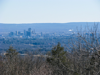
Air pollution becomes visible when fine particles scatter in the atmosphere and absorb light, limiting the distance people can see clearly. When the air is clean, visibility conditions in most of the Eastern United States are approximately 60-80 miles. However, when regional haze is present, visibility is reduced to a range of just 20-40 miles. Under the worst conditions, visibility can be reduced to just a few miles, as illustrated in the photos of Hartford, Connecticut, below.
Examples of a good visibility day (left) and a bad visibility day (right),
in Hartford, CT.
 |
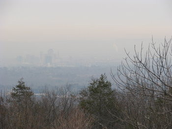 |
| Hartford on a clear day | Hartford on a hazy day |
Live HazeCam Photo of Hartford Connecticut
(from the Talcott Mountain Science Center)
(from the Talcott Mountain Science Center)
For a live view of the Talcott Mountain Science Center webcam, visit the Air Monitoring web page.
Visit www.hazecam.net for other Northeast visibility webcams.
What is Being Done?
The Federal Clean Air Act requires the Environmental Protection Agency (EPA) to address visibility impacted by haze in federal Class I areas (designated national parks and wilderness areas). In 1999, EPA issued the Regional Haze Rule, requiring states and interested tribes to take steps aimed at reducing emissions of haze-causing pollution from numerous sources. Under the rule, all states must identify key sources of haze-causing pollution, develop plans to reduce emissions from these sources, and submit these plans to EPA by December 17, 2007.
To facilitate this, EPA established five regional planning organizations across the nation. Connecticut belongs to the MANE-VU regional planning organization:
Mid-Atlantic/Northeast Region Visibility Union (MANE-VU)
Mid-Atlantic/Northeast Region Visibility Union (MANE-VU)
MANE-VU represents Connecticut, Delaware, the District of Columbia, Maine, Maryland, Massachusetts, New Hampshire, New Jersey, New York, Pennsylvania, the Penobscot tribe, Rhode Island, St. Regis Mohawk tribe and Vermont, as well as federal environment, forest, park and wildlife agencies. MANE-VU also works with Northeast States for Coordinated Air Use Management (NESCAUM) and the Mid-Atlantic Regional Air Management Association (MARAMA).
Seven Class I areas exist in the MANE-VU region. They are Moosehorn Wilderness Area, Roosevelt Campobello International Park, and Acadia National Park in Maine; Great Gulf Wilderness Area and Presidential Range - Dry River Wilderness Area in New Hampshire; Lye Brook Wilderness Area in Vermont; and Brigantine Wilderness Area in New Jersey.
Although the Regional Haze Rule is meant to reduce air pollution and increase visibility in Class I areas, efforts to clean up haze-causing pollution will also improve views of other natural areas and city skylines throughout the region, and will protect public health from the effects of fine particle pollution.
Current Topics
Haze Related Links
NESCAUM Haze information
U.S. Environmental Protection Agency (EPA)
National Park Service
American Lung Association
Regional Haze Planning Organizations:
Central States Regional Air Partnership (CENRAP)
Midwest Regional Planning Organization
Visibility Improvement State and Tribal Association of the Southeast (VISTAS)
Western Regional Air Partnership (WRAP)
Midwest Regional Planning Organization
Visibility Improvement State and Tribal Association of the Southeast (VISTAS)
Western Regional Air Partnership (WRAP)
Content Last Updated May 13, 2019