Directions to DEEP Facilities
Headquarters - 79 Elm Street, Hartford
Bureau of Energy and Technology Policy / Public Utilities Regulatory Authority (PURA) - Ten Franklin Square, New Britain
Marine District Headquarters - 333 Ferry Road, Old Lyme
Eastern District Headquarters - 209 Hebron Road, Marlborough
Western District Headquarters - (New location) 2065 Thomaston Road, Watertown (Black Rock State Park)
State Parks and Forests (Select park/forest for directions)
Educational Facilities
Dinosaur State Park - Rocky Hill
Goodwin Conservation Center - Hampton
Kellogg Environmental Center - Derby
Meigs Point Nature Center - Madison
Sessions Woods Conservation Education Center - Burlington
Fish Hatcheries
Burlington Trout Hatchery - Burlington
Quinebaug Hatchery Ponds - Plainfield
Wildlife Facilities
Franklin Wildlife Management Area - Franklin
Session Woods Wildlife Management Area - Burlington
Osborne Homestead Museum - Derby
Meigs Point Nature Center
The Meigs Point Nature Center is located at Hammonasset Beach State Park in Madison. The Center is open year round from Tuesday- Sunday. From March 1 through October 31, it is open from 10:00 AM - 5:00 PM and from November 1 through February 28 (off season) it is open from 10:00 AM - 4:00 PM.
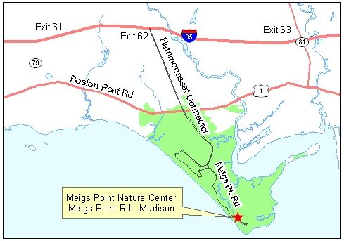
From I-95: Hammonasset Beach - Exit 62 off I-95 (Connecticut Turnpike). Follow the turnpike connector south to the park entrance. From the park entrance station, proceed on the main access road to a traffic circle. Go approximately 2/3 of the way around the circle and then follow directional signs for "Meigs Point" road. The Nature Center is on the left side of the road across from the Meigs Point bathhouse. There is a parking lot next to the building.
Marine District Headquarters
333 Ferry Road, Old Lyme
Boating Division - 860-434-8638
Walk-In Hours: 8:30 AM - 4:30 PM; closed from 12:30 PM-1:00 PM
Phone Hours: Monday through Friday, 7:45 AM - 4:30 PM
Walk-In Hours: 8:30 AM - 4:30 PM; closed from 12:30 PM-1:00 PM
Phone Hours: Monday through Friday, 8:30 AM to 4:30PM
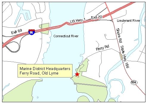
From the east: I-95 to exit 70; at light go straight on Halls Rd; at second light, go left on Route 156; go 1/2 mile and turn right on Ferry Rd to the end.
From the west: I-95 over the Connecticut River; take your first exit (exit 70) and turn right on Route 156; go 1/2 mile and turn right on Ferry Rd to the end.
Burlington Trout Hatchery
34 Belden Road, Burlington Phone: 860-673-2340
Open 7 days per week, 8:00 AM - 3:30 PM
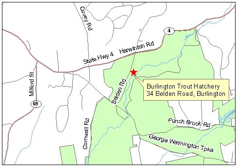
From Route 8 north: Route 44 east to Route 179 south; to Route 4 west, up hill to Belden Rd on left to hatchery.
From I-84 east or west: exit 39 (Route 4); go through Farmington and Unionville staying on Route. 4; drive along river to flashing light; turn left, staying on Route 4; go up hill about 2 miles and turn left on Belden Rd.
Quinebaug Hatchery Ponds
41 Trout Hatchery Road, Central Village (Plainfield) Phone: 860-564-7542
Open 7 days per week, 9:30 AM - 3:30 PM
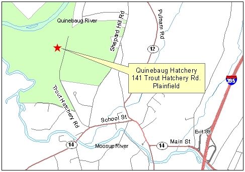
I-395 north or south to exit 89 (Route 14); Go west on Route. 14 through Central Village to a light; turn right and go about 1/2 mile; bear left at fork (stay on Route. 14) and go about 1/2 mile; turn right into Cady Lane to the hatchery
Lost? Call 860-564-7542
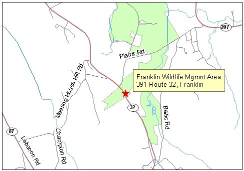
Franklin Wildlife Management Area
391 Route 32, North FranklinHours: Monday through Friday, 8:30 AM - 4:00 PM
Phone: 860-424-3011
From Route 2 Eastbound:
Take exit #27 for Route 32 North. On ramp stay to the right. Take a right for Route 32 North. Travel north on Route 32 for approximately 3.5 miles. Take a right onto Plains Road (just past signs for Franklin WMA) and then take your first right into the driveway (there is a sign for Franklin WMA here).
From Route 2 Westbound:
Take exit #25 for Route 32 North. Travel north on Route 32 for approximately 3.2 miles. Take a right onto Plains Road (just past signs for Franklin WMA) and then take your first right into the driveway (there is a sign for Franklin WMA here).
From I-395 Northbound:
Take exit #81W for Route 2 West. Travel west on Route 2 for approximately 1 mile. Take exit #25 for Route 32 North. Travel north on Route 32 for approximately 3.2 miles. Take a right onto Plains Road (just past signs for Franklin WMA) and then take your first right into the driveway (there is a sign for Franklin WMA here).
From I-395 Southbound:
Take exit #82 for Route 2 West and Route 32 North. Take a right at the end of the ramp and follow signs for Route 32 north. Travel north on Route 32 for approximately 3.5 miles. Take a right onto Plains Road (just past signs for Franklin WMA) and then take your first right into the driveway (there is a sign for Franklin WMA here).
Content last updated in October 2024.

