

Orthophotography and Other Large GIS Databases
Available on External Hard Drive
Statewide orthophoto mosaics and other large statewide GIS databases in ArcGIS File Geodatabase format are available from DEEP upon request. These databases are too large to download from the Internet so you can either obtain these databases from DEEP on your external hard drive or connect your GIS or CAD software to ArcGIS and WMS map services and access this information remotely from CT ECO. If you have ArcGIS Desktop software, select the Open in ArcMap links below to connect to each map service from CT ECO.
| GIS Data Layer Name |
Data
Description |
CT ECO
Map Service New! |
Geo Database
File Size |
|---|---|---|---|
| Elevation and Bathymetry | |||
| Elevation Contours | |||
| Connecticut 2 Feet Contours 5/18/2011 | Data Guide Metadata | Open in ArcMap |
Geo Database
or Shapefile: 2 GB |
| Connecticut 5 Feet Contours 5/18/2011 | Metadata | ||
| Connecticut 10 Feet Contours 5/18/2011 | Metadata | ||
| Connecticut 20 Feet Contours 5/18/2011 | Metadata | ||
| Connecticut 50 Feet Contours 5/18/2011 | Metadata | ||
| Connecticut 100 Feet Contours 5/18/2011 | Metadata | ||
| Terrain Datasets | |||
|
Connecticut Terrain Dataset -
Version 1 NEW! |
User Guide Metadata | 20 GB | |
|
Connecticut Terrain Dataset -
Version 2 NEW! |
Metadata | 17 GB | |
| Map Imagery | |||
| Statewide Topo Map Mosaics | |||
| Connecticut USGS Topographic Quad Maps | Metadata | 0.9 GB | |
| Orthophotography | |||
| Statewide Orthophotography Mosaics | |||
| Connecticut 1990 Orthophoto (leaf off) | Data Guide Metadata | Open in ArcMap | 59 GB |
| Connecticut 2004 Orthophoto (leaf off) | Data Guide Metadata | Open in ArcMap | 51 GB |
| Connecticut 2006 Color NAIP (leaf on) | Data Guide Metadata | Open in ArcMap | 18 GB |
| Connecticut 2008 (4 Band) Color and Infrared NAIP (leaf on) | Data Guide Metadata | Open Color in ArcMap Open Infrared in ArcMap | 21 GB |
| Connecticut 2010 (4 Band) Color and Infrared NAIP (leaf on)NEW! | Data Guide Metadata | Open Color in ArcMap Open Infrared in ArcMap | 25 GB |
| Connecticut 2008 Color Urban Area (leaf off) | Data Guide Metadata | Open in ArcMap | 78 GB |
| CRCOG 2009 Orthophotography (leaf off) NEW! | Data Guide Metadata | Open in ArcMap | 145 GB |
| Coastal CT 2004 Color Orthphoto (leaf on) | Data Guide Metadata | Open in ArcMap | 12 GB |
| Coastal CT 2004 Infrared Orthophoto (leaf on) | Data Guide Metadata | Open in ArcMap | 10 GB |
| Coastal CT 2005 Infrared Orthophoto (leaf on) | Data Guide Metadata | Open in ArcMap | 21 GB |
| Coastal CT 2010 (4 Band) Color and Infrared Orthophoto (leaf on) NEW! | Data Guide Metadata | Open Color in ArcMap Open Infrared in ArcMap | 31 GB |
Instructions for ordering data on external hard drive
Follow these steps to request the data on an external hard drive you provide.
- Mail an external hard drive with a list of the data you want to:
Office of Information Management, GIS Section
Connecticut Department of Energy & Environmental Protection
79 Elm Street
Hartford, CT 06106.
- Return shipping must be pre-paid by the requestor in order for DEEP to mail the external device back to you.
- Be sure there is enough space on the hard drive for the data you want. File sizes are listed in the table above.
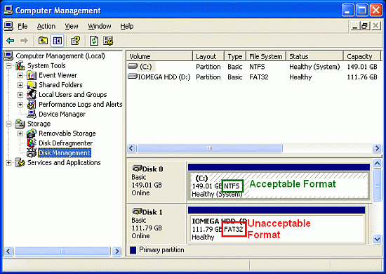
- Be sure to send an "NTFS" and not an "FAT32" formatted hard drive. To determine the format type, connect your hard drive to your PC. In Windows XP, right click on "My Computer" on the desktop and go to "Manage". Click on "Disk Management" to see the format information, as shown below. The NTFS format is acceptable; the FAT32 format is not acceptable.
Map Service Instructions
Go to CT ECO Map Services for more information about connecting ArcMap and CAD software to ArcGIS and WMS map services for this information. CAD software users should refer to the instructions for using WMS map services available in CT ECO Map Service FAQs.
Contact Us
Contact us if you have any questions about obtaining or using this information.
Telephone: 860-424-3540