
Lake Winnemaug 2005
Lake Winnemaug, Watertown
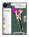
2005 Aquatic Plant Survey Map of Lake Winnemaug
Transect Data | Water Data
Lake Winnemaug is an 112.9-acre body of water that is artificially impounded by a masonry and earthen dam. It is bounded by a road on its eastern shore. The shoreline is heavily settled with mostly summer cottages with the exception of the southern end. The maximum depth is 16.5 feet (5 m) and the mean depth is 7.9 feet (2.5 m).
Our survey of aquatic vegetation in September 2005 found snailseed pondweed (Potamogeton bicupulatus) as the most widespread species. It was found mostly in the southern end of the lake. Most vegetation was restricted to the southwestern cove in depths less than 3 feet. The invasive brittle waternymph (Najas minor) was also found there. Small patches of charaphyte and arrowhead (Sagittaria species) were observed in the northwestern part of the lake, but nowhere else.
| Species recorded in our 2005 survey of Lake *Invasive species |
|
| Arrowhead | Slender naiad |
| Charaphyte |
Small waterwort |
| Eelgrass |
Snailseed Pondweed |
| Minor naiad* |
Spikerush |
/valame_winnemauglake_watertown_09-06-05069.jpg)
/potbic_winnemauglake_watertown_09-06-05909.jpg)
/najmin_winnemauglake_watertown_09-06-05125.jpg)