
Thirsty Lake 2022
Thirsty Lake, Guilford - 2022
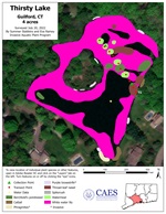
2022 Aquatic Plant Survey Map of Thirsty Lake
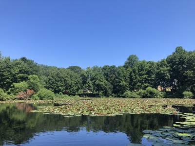
Thirsty Lake is a four-acre, private lake in Guilford, CT. It is in the West River watershed, which drains into Long Island Sound. There is an island in the middle of the lake and several shoreline homes. The lake provides wildlife habitat and recreational opportunities for abutting landowners including swimming, fishing, and kayaking.
The 2022 survey of Thirsty Lake is the first survey conducted by CAES IAPP. There were five aquatic plant species, none of which were invasive (non-native). White water lily covered approximately two thirds of the lake’s surface and could be considered a nuisance. When a lake is covered by water lilies, they restrict light from reaching the bottom and thus create an environment where other plant species cannot survive. The remaining plants were found in sparse abundance. They included Berchtold's pondweed, thread-leaf naiad, spikerush, and watermeal. Cattail, phragmites, and purple loosestrife were also present. These are nonaquatic shoreline plant species that can become a nuisance. Cattail is a native species, while phragmites and purple loosestrife are invasive.
Water data was collected on the day of the survey in the deepest part of the lake (10 feet). Water clarity was measured with a Secchi disk and was about 3 feet. Dissolved oxygen in Thirsty Lake was low at both the surface (1.3 ppm) and at the bottom (0.4 ppm). These are anaerobic conditions where fish and other aquatic organisms will have difficulty surviving. Phosphorous (P) concentrations were 21 ppb at the surface and 83 ppb at the bottom. Lakes with surface P levels from 0 - 10 ppb are considered nutrient-poor or oligotrophic. When P concentrations reach 15 - 25 ppb, lakes are classified as moderately fertile or mesotrophic and when P reaches 30 - 50 ppb they are considered fertile or eutrophic. Lakes with P concentrations >50 ppb are categorized as extremely fertile or hypereutrophic. Bottom P concentrations are often elevated in the summer due to nutrient accumulation from decaying organic matter in a thermally stratified environment. P concentrations in water samples from heavily vegetated waterbodies taken during the growing season can be misleadingly lower than at other times because of the removal of P by plants.
|
Species recorded in the 2022 survey of Thirsty Lake |
|||
| Berchtold's pondweed | Cattail | Phragmites* | Purple loosestrife* |
| Thread-leaf naiad | Spikerush | Watermeal | White water lily |
| Southern naiad | |||