
Talmage Pond 2006
Talmage Pond, Branford
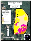
Talmage Pond is a 3-acre waterbody located to the north of Route 142 in Branford. It is bordered to the east by land owned by the Branford Land Conservation Trust. Residential development occurs along the western and southern shores. The western shore also has rock outcrops. No pollution sources were evident. Talmage Pond is very shallow with the deepest section near 3 feet.
Most of the pond is covered with emergent vegetation making navigation even by canoe a challenge. Most of this coverage is watershield (Brasenia schreberi) with significant populations of white water lily (Nymphaea odorata) and yellow water lily (Nuphar variegata). Submersed species covering the bottom were coontail (Ceratophyllum demersum), small pondweed (Potamogeton pusillus), and humped bladderwort (Utricularia gibba). Sparse common duckweed (Lemna minor) was also present. Shoreline residents have complained about the copious vegetation, and discussions are in progress about management options. Hand removal has been is the only known control method used.
| Species recorded in our 2006 survey of Talmage Pond. Scientific Names |
|
| Coontail | Watershield |
| Humped bladderwort | White water lily |
| Small pondweed | Yellow water lily |