
Lower Mills Pond 2005
Lower Mills Pond, Canton
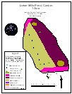
2005 Aquatic Plant Survey Map of Lower Mills Pond
Lower Mills Pond generally 1-3 feet deep, with the exception of 5 feet near the dam in the southeast of the lake. The pond is bordered by a small patch of woods to the north and by mowed lawn to the east and west. East Hill Road runs along the pond’s southern edge.
Lower Mills Pond is not far downstream from the larger Upper Mills Pond, but the plant communities are different. During our July 2005 survey, watermeal (Wolffia species) completely covered the west half of the pond while it only thinly covered the east half. Coontail (Ceratophyllum demersum)occurred abundantly under the watermeal on the west half of the pond and less abundantly on the east half of the pond. Humped bladderwort (Utricularia gibba) grew abundantly throughout the pond while western waterweed (Elodea nuttallii) was scattered. The invasive Eurasian watermilfoil (Myriophyllum spicatum) occurred on the eastern half of the pond. White water lily (Nymphaea odorata) grew in two patches along the ponds northern and southern edges along with two small patches of small pondweed (Potamogeton pusillus).
| Species recorded in our 2005 survey of Lower Mills Pond. Scientific Names *Invasive Species |
|
| Coontail | Southern naiad |
| Eurasian watermilfoil* | Watermeal |
| Humped bladderwort | Western waterweed |
| Small pondweed | White water lily |