
Millers Pond 2005
Millers Pond, Durham
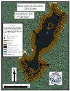
2005 Aquatic Plant Survey Map of Millers Pond
The 33-acre Millers Pond is entirely within the forested Millers Pond State Park, and there is no development in the park. The pond has a maximum depth of 18 feet and a mean of 11 feet. The edges of the pond are rocky in many areas, and the bottom drops steeply, providing little shallow-water area where sediment can accumulate and plants can colonize. There is no boat ramp on the pond, although canoes and kayaks can be carried from a parking area about 600 feet from the shore.
During our August 2005 survey, aquatic plants were not abundant. Golden hedge-hyssop (Gratiola aurea) and needle spikerush (Eleocharis acicularis) occurred in scattered patches on all sides of the pond. Low watermilfoil (Myriophyllum humile) occurred in three areas at the northern and southern ends of the pond. Snailseed pondweed (Potamogeton bicupulatus) was found in several large patches along the southern shore. Quillwort (Isoëtes species) was recorded in one location near the dam in the southwest, and charaphyte (Chara) was recorded in one place on the southeast side of the pond.
| Species recorded in our 2005 survey of Millers Pond. Scientific Names |
|
| Charaphyte | Needle spikerush |
| Golden hedge-hyssop | Quillwort |
| Low watermilfoil | Small pondweed |