
Mamanasco Lake 2005
Mamanasco Lake, Ridgefield - 2005
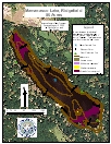
2005 Aquatic Plant Survey Map of Mamanasco Lake
Mamanasco Lake has a surface area of 89.2 acres with a maximum depth of 11 feet and a mean depth of 7.5 feet. The east side of the lake is moderately developed, but most of the houses have shoreline buffer zones. The west side is thickly settled and bounded by a road. The houses on the west side of the lake did not have buffers. The State owns a boat launch on the southern end of the lake. Gas-powered motors are prohibited.
Mamanasco Lake has been treated with herbicides in the past to reduce the population of invasive Eurasian watermilfoil (Myriophyllum spicatum) and algae. Hydro-raking was done about 10 years ago, and two applications of copper sulfate were done in the last 5 years to reduce algae. Eurasian watermilfoil was treated with in June 2005 with fluridone thus effecting our August 2005 survey. To assist in the effectiveness of the treatment, Mamanasco’s water level was lowered. The water level was still lower than normal our survey.
The invasive Eurasian watermilfoil was the dominant species during the survey. It occurred in an almost continuous ring around the lake in depths less than 9 feet. The invasive common water hyacinth (Eichhornia crassipes) was also found during the survey. Only a couple of plants of this species were found on the west side of the lake. Native yellow water lily (Nuphar variegata) was in sparse patches on the west and east side in water less than 3 feet deep. A small amount of common duckweed (Lemna minor) occurred by the boat launch at the southern end of the lake.
| Species recorded in our 2005 survey of Mamanasco Lake. Scientific Names *Invasive Species |
|
| Common duckweed | Eurasian watermilfoil* |
| Common water hyacinth* | Yellow water lily |