
Ivoryton Pond 2006
Ivoryton Pond, Ivoryton
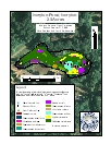
Ivoryton Pond is a small pond formed by the damming of the
Approximately half of the pond was covered with emergent vegetation primarily watershield (Brasenia schreberi) and a smaller amount of yellow water lily (Nuphar variegata). Submersed, invasive fanwort (Cabomba caroliniana) covered about three quarters of the bottom with occasional flowers breaking the surface. Inspection of several upstream ponds and a resident report from a downstream pond indicate fanwort is present throughout the ponds connected to this waterway. Several unobtrusive native pondweeds (Potamogeton) are present as are common bladderwort (Utricularia macrorhiza) and western waterweed (Elodea nuttallii).
| Species recorded in our 2006 survey of Ivoryton Pond. Scientific Names *Invasive Species |
|
| Common bladderwort | Spotted pondweed |
| Fanwort* | Watershield |
| Small pondweed | Western waterweed |
| Snailseed pondweed | Yellow water lily |