
Howells Pond 2005
Howells Pond, Hartland
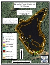
2005 Aquatic Plant Survey Map of Howells Pond
Howells Pond is a 14.3-acre waterbody located in Tunxis State Forest. The maximum depth of Howells Pond is 8.1 feet, and the mean depth is 6.4 feet. There is no residential development, only thickly wooded areas around the water’s edge. There is a boat launch owned by the state on the southeastern shore near the dam. Gas motors are not allowed on the pond. A pipe for filling up fire trucks is found near the boat launch.
Our August 2005 survey found common bladderwort (Utricularia macrorhiza) to be the most widespread plant, absent only from small parts of the northwestern and eastern shorelines. Watershield (Brasenia schreberi) and ribbon-leaf pondweed (Potamogeton epihydrus) also were found on all sides of the pond as small and large patches. Southern naiad (Najas guadalupensis), bur-reed (Sparganium species), pickerelweed (Pontederia cordata), spotted pondweed (Potamogeton pulcher), and low watermilfoil (Myriophyllum humile) were found as several small patches in the southern edge of the lake. Yellow water lily (Nuphar variegata) and snailseed pondweed (Potamogeton bicupulatus) also were found in the southern portion of the lake, as well as the north and west sides.
| Species recorded in our 2005 survey of Howells Pond. Scientific Names |
||
| Bur-Reed | Pickerelweed | Southern naiad |
| Common bladderwort | Ribbon-Leaf pondweed | Watershield |
| Low watermilfoil | Snailseed pondweed | Yellow water lily |