
Dayton Pond 2005
Dayton Pond, Wallingford
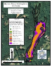
2005 Aquatic Plant Survey Map of Dayton Pond
Dayton Pond was created by damming a stream in eastern Wallingford. It is within the Muddy River/Tyler Mill recreation area that is maintained by the town as open space. The 6.6-acre pond is largely less than 1 foot deep. Bushes and other emergent plants grow in two areas in the northern end of the pond, creating small islands. The land around the pond is wooded, although two houses are visible through the trees on the western side.
During our July 2005 survey, western waterweed (Elodea nuttallii) and coontail (Ceratophyllum demersum) were found in continuous beds across the pond, though somewhat less abundantly in shallow water along the edges. The invasive Eurasian watermilfoil (Myriophyllum spicatum) was observed in one location in the center of the pond, and leafy pondweed (Potamogeton foliosus) was recorded in two small patches. A few plants of clasping-leaf pondweed (Potamogeton perfoliatus) and long-leaf pondweed (Potamogeton nodosus) were found on the eastern shore. Common duckweed (Lemna minor) and great duckweed (Spirodela polyrhiza) occurred along the eastern shore and southern shores.
| Species recorded in our 2005 survey of Dayton Pond. Scientific Names *Invasive Species |
|
| Clasping-Leaf pondweed | Great duckweed |
| Common duckweed | Leafy pondweed |
| Coontail | Long-Leaf pondweed |
| Eurasian watermilfoil* | Western waterweed |