
Tidal Wetlands
GIS Data Guide
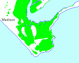
Tidal Wetlands - 1970's and 1990's
| Publisher | Connecticut DEP, Office of Long Island Sound Programs | |
|---|---|---|
| Publication Date | 2002 | |
| Data Collection Scale | 1:24,000 | |
| Data Collection Date | See below | |
| Update Frequency | Not updated DEP GIS Data Downloads | |
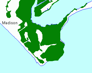
1990's Tidal Wetlands
This coverage shows all mapped tidal wetlands across the state of Connecticut. The mapping has been compiled from two sources; the 1994 Ramsar Tidal Wetlands Mapping and the 1995 OLISP Tidal Wetlands Mapping, both produced by the State of Connecticut, Department of Long Island Sound Programs. The tidal wetland boundaries are not regulatory boundaries but should be interpreted as a guide to the location of tidal wetlands throughout the state.
The Ramsar tidal wetlands mapping extends south from Cromwell Connecticut to the mouth of the Connecticut River. 1990, 1:12,000 scale, color infrared aerial photographs were used to identify the tidal wetland boundaries. These boundaries were mapped and transposed onto a topographic map base and digitized.
The 1995 OLISP Tidal Wetlands Mapping covers all the tidal wetlands in Connecticut that were not mapped as part of the Ramsar project. The mapping was done using 1995, 1:12,000 scale, color infrared aerial photographs and 1990/91 black and white Digital Orthophotographs. Tidal wetlands were identified on the 1995 aerial photographs and then digitized in ArcEdit using the digital orthophoto as the map base. This mapping process has resulted in a very geometrically accurate map but one that does not align perfectly with the older topographic base data such as the RAMSAR mapping and much of the DEP library information such as roads and hydrography. Boundary lines are as precise as the source information permit.
NOTES: With the exception of the Connecticut River data both Ramsar and other mapping, coverage polygons have not been thoroughly verified and are still considered DRAFT quality. The tidal wetland polygons north of the Ramsar Data, on the Connecticut River, were checked by Ken Metzler of the Environmental and Geographic Information Center.
Theme Properties
| Theme Name | Tidal Wetlands 1970's or 1990's |
|---|---|
| Data Source | tidalwetlands1970s [1990s] .shp |
| Recommended Minimum Display Scale | None |
| Recommended Maximum Display Scale | None |
| Recommended Label Field | Av_Legend |
| Legend Classification Field | None (single symbol) |
Theme Attribute Table
| Field | Name | Description | Type | Units | Domain |
|---|---|---|---|---|---|
| Av_Legend | Arcview Legend | Generates a Legend in Arcview | string | "T_Wetlands", null | |
| Class | Classification | Numeric Code to designate existence of wetlands | integer | 111, 0 | |
| Acreage | Acreage | Acreage of All Polygons | number | acres | >0 |
| Source | Source | Tags the Source Coverage of Each Polygon | string | "OLISP1995AIRPHOTOS", "RAMSAR" |
Horizontal Coordinate System
| Coordinate System | State Plane Coordinate System of 1983 |
|---|---|
| State Plane Zone | Connecticut, Zone 3526 |
| Horizontal Datum | North American Datum of 1983 (NAD 83) |
| Map Projection | Lambert Conformal Conic |
| Spheriod | GRS 80 |
| Map Scale | 1:24,000 |
| Map Units | Feet |
Point of Contact
| Organization | State of Connecticut Department of Environmental Protection |
|---|---|
| Mailing Address | 79 Elm Street Hartford, CT 06106-5127 |
| Phone | (860) 424-3540 |
| Fax | (860) 424-4058 |
| deep.helpdesk.footprints@ct.gov |