
General Description and Facts
Within its compact borders, Connecticut has forested hills, new urban skylines, shoreline beaches, white-steeple colonial churches, and historic village greens. There are classic Ivy League schools, modern expressways, great corporate offices, and small farms. Connecticut is a thriving center of business, as well as a vacation land. It is both a New England state, and neighbor to New York City and Boston.
Name of State: Connecticut
Statehood: January 9, 1788 (5th state)
Nickname/Official Designation: "The Constitution State" was adopted by Act of the Legislature, 1959.
Name Origin/Indian: Quinnehtukqut -- Mohegan for "Long River Place" or "Beside the Long Tidal River"
Capitol: Hartford, the sole Capital City since 1875
Governor: Ned Lamont
State Motto: Qui Transtulit Sustinet -- "He Who Transplanted Still Sustains"
Population: The population of Connecticut was 3,574,097 according to the 2010 U.S. Official Census. The most recent population estimate from the Connecticut Department of Public Health is 3,590,886 as of July 1, 2015.
Cities with largest population (2010):
- Bridgeport 144,229
- New Haven 129,779
- Hartford 124,775
- Stamford 122,643
- Waterbury 110,366
Area: 5,018 square miles
Counties: 8
Towns: 169
Cities: 21
Boroughs: 9
Famous For: Inventors (Charles Goodyear, Elias Howe, Eli Whitney, Eli Terry); inventions (watchmaking, typewriters); insurance; submarines; PEZ; steamed cheeseburgers; hot lobster rolls; and the best pizza in the world
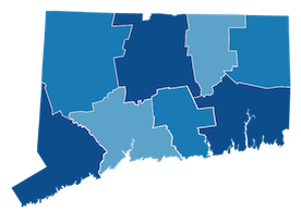
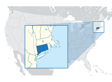
Above is a picture of Connecticut, including its 8 counties. See a list of the cities and towns in the state of Connecticut.